Mostly Dry Labor Day Weekend Ahead
ALABAMA’S WEATHER STAYS QUIET: While our tropical system passes east of the state, Alabama will stay in a rather benign weather pattern through the weekend. We will mention just the risk of a few isolated showers over the eastern counties (mainly east of I-65) this afternoon, but the chance of any one spot getting wet is only 15 percent. On the positive side, heat levels come down today, and most places will stay under 90 degrees with a partly sunny sky.
TOMORROW THROUGH MONDAY: A generally dry pattern continues over the holiday weekend for the northern half of Alabama. While the chance of rain won’t be zero, odds are very small of any one spot seeing shower, and we won’t mention it in the forecast. Moisture will be a bit deeper over South Alabama, so a few widely scattered showers and storms are possible there, but nothing really widespread. We will project a high between 87 and 90 degrees tomorrow and Sunday, and right around 90 Monday.
FOOTBALL WEATHER: Mostly fair weather for the high school games tonight with temperatures falling into the 70s; it won’t be quite as humid as the first two weeks of the season.
Auburn will host Clemson tomorrow evening at Jordan-Hare Stadium (8p CT kickoff); the sky will be mostly clear with temperatures falling from near 77 degrees at kickoff to near 74 at the final whistle.
Alabama opens the season against Southern Cal in Arlington, Texas tomorrow evening (7p CT kickoff)… the game is inside the “Jerry Dome”, but no weather issues for tailgaters. Clear weather is the story with temperatures falling from the low 80s at kickoff into the 70s.
NEXT WEEK: Heat levels creep up again, with low to mid 90s by mid-week and only widely scattered, mostly afternoon and evening showers and thunderstorms. See the Weather Xtreme video for maps, graphics, and more details.
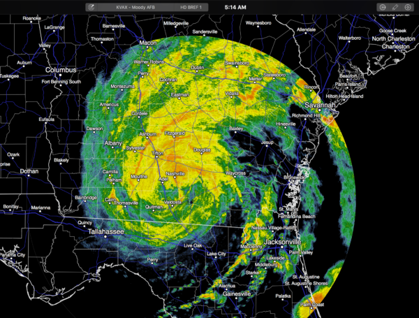
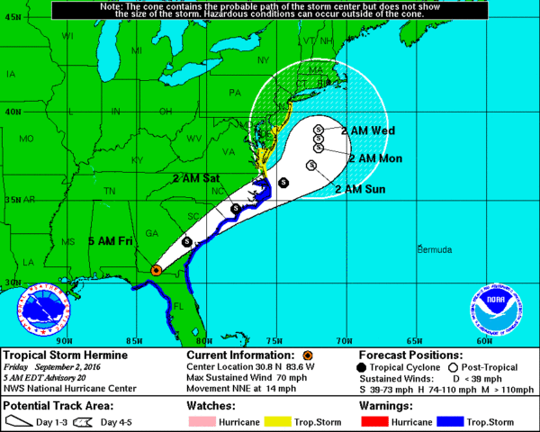
HERMINE OVER GEORGIA: Now a tropical storm, Hermine is moving northeast through southern Georgia this morning. It came ashore last night as a category one hurricane near Alligator Point (south of Tallahassee), and there has been extensive storm surge damage in places like Cedar Key. As we forecast, Panama City Beach and Destin were on the dry side of the system with little rain and no issues.
Hermine will continue to move northeast in coming days, then stalling out and hanging around just off the Delaware and New Jersey coasts next week.
AT THE BEACH: About 7 to 9 hours of sunshine each day through Labor Day from Gulf Shore over to Panama City Beach, with just a few widely scattered showers or storms. Highs in the upper 80s on the immediate coast, with low 90s inland. The Gulf of Mexico will settle down and the rip current danger will subside over the weekend. See a very detailed Gulf Coast forecast here.
TROPICS: A wave is moving along in the Central Atlantic, but it is fighting very dry and, and it remains to be seen if it can survive. And, Gaston is a tropical storm now in the North Atlantic approaching the Azores. Noting threatening the Gulf of Mexico for at least the next seven days.
WEATHER BRAINS: Don’t forget you can listen to our weekly 90 minute netcast anytime on the web, or on iTunes. This is the show all about weather featuring many familiar voices, including our meteorologists here at ABC 33/40.
CONNECT: You can find me on all of the major social networks…
Facebook
Twitter
Google Plus
Instagram
Look for the next Weather Xtreme video here by 4:00 this afternoon… enjoy the day!
Category: Alabama's Weather
About the Author (Author Profile)
James Spann is one of the most recognized and trusted television meteorologists in the industry. He holds the AMS CCM designation and television seals from the AMS and NWA. He is a past winner of the Broadcast Meteorologist of the Year from both professional organizations.Subscribe
If you enjoyed this article, subscribe to receive more just like it.


