

Dry Pattern Holds Into Next Week
PLEASANT MORNING: Temperatures are down in the 60s early this morning across much of North/Central Alabama… our Skywatcher up at Black Creek in Etowah County, Vic Bell, reports 62 degrees just before sunrise for a nice touch of fall.
The air remains very dry across Alabama, and we expect a good supply of sunshine today with a hot afternoon; most places reach the mid 90s today. But, at least the humidity levels won’t be bad with low dew points remaining in place. No chance of rain.
AIR QUALITY ALERT: A “code orange” alert has been issued for Jefferson/Shelby Counties for today due potential for ground level ozone.
TOMORROW THROUGH SATURDAY: No real change. Mostly sunny days with hot afternoons, and clear pleasant nights. Highs in the 92-95 degree range, with lows mostly in the 60s. Humidity levels will remain fairly low with an upper high overhead.
A weak surface front will drift into North Alabama Sunday, and we will mention a slight risk of a shower, but for now it looks like the chance of any one spot getting wet is only about one in ten with little moisture and no upper support. The high Sunday will drop back slightly into the upper 80s.
NEXT WEEK: Sure looks like a continuation of dry weather, at least for the first half of the week. Highs 87-90, with lows in the 60s. Unfortunately we still see no really widespread rain event for the next ten days across Alabama as the dry pattern holds. See the Weather Xtreme video for maps, graphics, and more details.
FOOTBALL WEATHER: High school games played under Friday night lights across Alabama will be rain-free with a clear sky; temperatures will fall from the mid 80s at kickoff into the 70s by the final whistle.
Alabama hosts Western Kentucky Saturday at Bryant-Denny Stadium for the 2016 home opener (2:30p CT kickofF)… the sky will be mostly sunny with 90 degrees at kickoff… dropping back into the mid to upper 80s by the end of the game.
Auburn will host Arkansas State at Jordan Hare Stadium Saturday evening (6:30p CT kickoff)… the sky will be clear with temperatures falling from 86 degrees at kickoff into the upper 70s by the fourth quarter.
AT THE BEACH: Mostly sunny days, fair nights, and only widely scattered storms along the coast from Gulf Shores to Panama City Beach through the weekend. Highs in the upper 80s on the immediate coast, with low 90s inland. See a very detailed Gulf Coast forecast here.
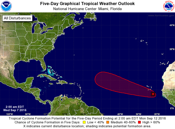
TROPICS: We are down to just one tropical disturbance to watch in the Atlantic basin (for now)… a wave in the eastern Atlantic has a high chance of developing over the next five days, but it remains to be seen if this will recurve over open water, or impact any landmass.
WEATHER BRAINS: Don’t forget you can listen to our weekly 90 minute netcast anytime on the web, or on iTunes. This is the show all about weather featuring many familiar voices, including our meteorologists here at ABC 33/40. Scroll down for the show notes on the new episode we recorded last night.
CONNECT: You can find me on all of the major social networks…
Facebook
Twitter
Google Plus
Instagram
Look for the next Weather Xtreme video here by 4:00 this afternoon… enjoy the day!
Category: Alabama's Weather
About the Author (Author Profile)
James Spann is one of the most recognized and trusted television meteorologists in the industry. He holds the AMS CCM designation and television seals from the AMS and NWA. He is a past winner of the Broadcast Meteorologist of the Year from both professional organizations.Subscribe
If you enjoyed this article, subscribe to receive more just like it.


