Only Isolated Storms Later Today
ON THE MAPS: We have a surface front pretty much bisecting Alabama this morning; north of the front the air is drier, and temperatures have dropped into the upper 50s for a nice taste of fall. Muscle Shoals is down to 57, while Fort Payne reports 59 just before sunrise. South of the front temperatures are in the low 70s.
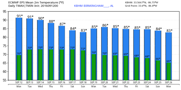
A few showers and storms could form again this afternoon and early tonight along and south of the front, but they should be widely scattered. Best chance of a storm will be over the southern half of the state, and the high this afternoon will be between 87 and 90 degrees for most communities.
MID-WEEK: The front will wash out tomorrow, and we will stick with a standard late summer forecast tomorrow through Thursday. Partly sunny days, and the risk of “widely scattered, mostly afternoon and evening showers and thunderstorms”. Highs 88 to 91; early morning lows around 70.
FRIDAY AND THE WEEKEND: The upper ridge over the region will weaken a bit, and a surface front will approach from the north. This should mean a general increase in the number of scattered showers and storms across Alabama. I still don’t expect the kind of widespread rain we really need, but at least the chance will be there for a few passing showers or thunderstorms. Otherwise, expect a mix of sun and clouds on these three days with highs between 86 and 89 degrees.
FOOTBALL WEATHER: Auburn will host Texas A&M Saturday evening at Jordan-Hare Stadium (6:30p CT kickoff)… a shower or thunderstorm will be possible during the game with a mostly cloudy sky. Temperatures will fall from near 84 degrees at kickoff, into the upper 70s by the final whistle.
Alabama travels to Oxford to play Ole Miss Saturday (2:30p CT kickoff). The sky will be mostly cloudy, and a passing shower or storm is likely during the game. Temperatures will hover in the mid 80s.
NEXT WEEK: Drier air drops southward, so the chance of rain looks fairly small, or will be non existent for the first half of the week over the northern half of Alabama. Highs will be in the 80s.
CLIMATOLOGY: The average high in Birmingham doesn’t fall below 80 degrees until October 3. And, usually the first good Canadian cold front of the season arrives in late September or early October. September is almost always a very warm month… triple digit heat has been recorded in Birmingham as late as September 22 (way back in 1925).
AT THE BEACH: About 7 to 9 hours of sunshine on the Gulf Coast (Panama City Beach over to Gulf Shores) this week with a few scattered storms. Highs in the upper 80s on the immediate coast, with low 90s inland. See a very detailed Gulf Coast forecast here.
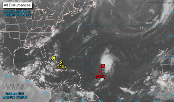
TROPICS: A disturbance in the Atlantic has a good chance of becoming a tropical depression or storm within the next 48 hours, but it will move north and is no threat to land. The rest of the Atlantic basin is pretty quiet, considering the fact this is the peak of the Atlantic hurricane season.
WEATHER BRAINS: Don’t forget you can listen to our weekly 90 minute netcast anytime on the web, or on iTunes. This is the show all about weather featuring many familiar voices, including our meteorologists here at ABC 33/40. We will produce this week’s show tonight at 8:30 CT… you can watch it live here.
CONNECT: You can find me on all of the major social networks…
Facebook
Twitter
Google Plus
Instagram
Look for the next Weather Xtreme video here by 4:00 this afternoon… enjoy the day…
Category: Alabama's Weather
About the Author (Author Profile)
James Spann is one of the most recognized and trusted television meteorologists in the industry. He holds the AMS CCM designation and television seals from the AMS and NWA. He is a past winner of the Broadcast Meteorologist of the Year from both professional organizations.Subscribe
If you enjoyed this article, subscribe to receive more just like it.


