Alabama Dry; Matthew Just Off The Florida Coast
ALABAMA DROUGHT WORSENS: Today is the 19th consecutive day with no measurable rain for Birmingham, and the chance of rain for the next 7 to 10 days is pretty much zero. So, drought conditions will continue to worsen across Alabama. Conserve water, and be extremely careful with any outdoor burning.
A “stage two” drought advisory remains in effect for Birmingham Water Works customers, and the Alabama Forestry Commission continues a Fire Danger Warning for 46 Alabama counties over the north and central part of the state.
Look for sunny days and fair nights through the weekend and next week. Highs stay in the 80s through Saturday, but dropping into the 76-80 degree range Sunday and through much of next week. Many places will see lows down in the upper 40s by Sunday and Monday morning.
FOOTBALL WEATHER: Another delightful night for high school football games tonight… clear with temperatures falling through the 60s.
Auburn will play at Mississippi State tomorrow (11:00a CT kickoff)… the sky will be sunny with temperatures rising from 78 at kickoff, to near 85 degrees by the fourth quarter.
Alabama is also on the road; they play Arkansas at Fayetteville tomorrow evening (6:00p CT kickoff)… a perfect evening for football with temperatures falling from 67 at kickoff into the 50s by the fourth quarter. The sky will be clear.
BARBER VINTAGE MOTORCYCLE FESTIVAL: This event runs through Sunday at the Barber Motorsports Park. Highs in the mid 80s today and tomorrow, cooling slightly into the low 80s Sunday. Sunny days, clear nights. Get ticket information right here.
GULF COAST WEATHER: Sunny days, fair nights on the coast from Gulf Shores to Panama City Beach through next week; highs in the 80s. See a very detailed Gulf Coast forecast here.
NICOLE: A hurricane in the Atlantic between Puerto Rico and Bermuda with sustained winds of 100 mph, this will drift around through the middle of next week and is no threat to land in the short term.
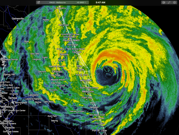
MATTHEW: The eye is just offshore early this morning; the eyewall brushed Cape Canaveral with a peak wind gust of 102 mph before sunrise.
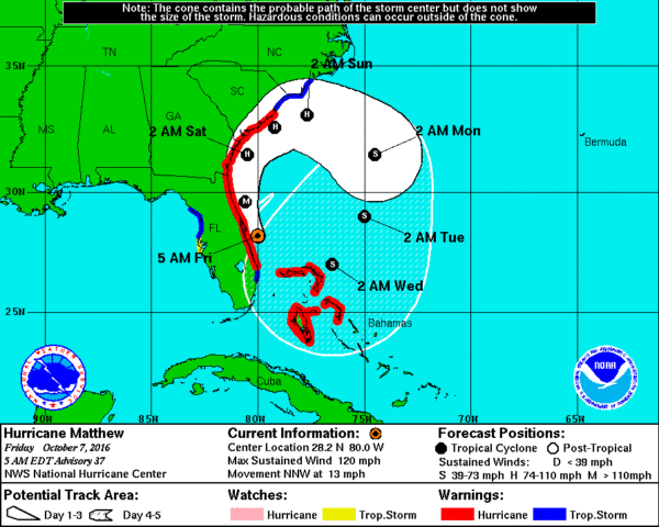
Maximum sustained winds are 120 mph, and it looks like the center will remain just offshore as it moves parallel to the South Atlantic coast of the U.S. through the weekend. If there is no landfall, the long “hurricane drought” continues for the U.S… it has now been 4001 days since a major hurricane made landfall on our shores; that was Hurricane Wilma back on October 24, 2005.
FLORIDA IMPACT: Here is a look at observations at 6a ET…
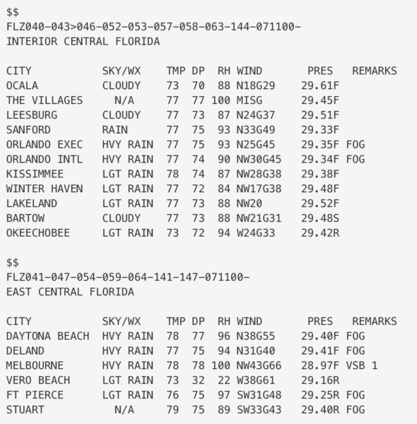
You can see at Orlando, winds are averaging 25-30 mph with gusts to 45. They are on the “good” west side of the circulation, and there won’t be any flooding or damage… which is the reason we advised Disney World guests just to hang tight, and for those planning a vacation there not to cancel. The parks reopen tomorrow, and the weather will be beautiful this weekend.
Winds, of course, are much higher on the immediate coast, where mass evacuations were carried out. But, with the eye remaining offshore that will reduce the amount of damage thankfully. As we have discussed for days, minor deviations in the track of the eye will make a huge difference in the impact.
Matthew will loop off the Southeast Coast of the U.S. early next week; the latest global models now suggest this will come back toward the Bahamas as a much weaker tropical storm, then drifting down toward Cuba without entering the Gulf of Mexico.
WEATHER BRAINS: Don’t forget you can listen to our weekly 90 minute netcast anytime on the web, or on iTunes. This is the show all about weather featuring many familiar voices, including our meteorologists here at ABC 33/40.
CONNECT: You can find me on all of the major social networks…
Facebook
Twitter
Google Plus
Instagram
Look for the next Weather Xtreme video here by 4:00 this afternoon… enjoy the day!
Category: Alabama's Weather
About the Author (Author Profile)
James Spann is one of the most recognized and trusted television meteorologists in the industry. He holds the AMS CCM designation and television seals from the AMS and NWA. He is a past winner of the Broadcast Meteorologist of the Year from both professional organizations.Subscribe
If you enjoyed this article, subscribe to receive more just like it.


