Matthew Nearing Florida; Alabama Stays Dry
STILL DRY: Before we get into the details on Hurricane Matthew, we note that there still isn’t much hope for Alabama in terms of beneficial rain. A very dry pattern for the next 10 days with warm afternoons and pleasant nights. Highs in the 80s through the weekend, then in the 70s early next week. A chance we hit the 40s early Sunday, Monday, and Tuesday morning.
Today is the 18th consecutive day with no measurable rain for Birmingham. Conserve water, and be extremely careful with any outdoor burning.
A “stage two” drought advisory is now in effect for Birmingham Water Works customers, and the Alabama Forestry Commission has issued a Fire Danger Warning for 46 Alabama counties over the north and central part of the state.
FOOTBALL WEATHER: Another delightful night for high school football games tomorrow night… clear with temperatures falling through the 60s.
Auburn will play at Mississippi State Saturday (11:00a CT kickoff)… the sky will be sunny with temperatures rising from 78 at kickoff, to near 83 degrees by the fourth quarter.
Alabama is also on the road; they play Arkansas at Fayetteville Saturday evening (6:00p CT kickoff)… a perfect evening for football with temperatures falling from 67 at kickoff into the 50s by the fourth quarter. The sky will be clear.
BARBER VINTAGE MOTORCYCLE FESTIVAL: This event runs from tomorrow through Sunday at the Barber Motorsports Park. Highs in the mid 80s tomorrow and Saturday, cooling slightly into the low 80s Sunday. Sunny days, clear nights. Get ticket information right here.
GULF COAST WEATHER: Mostly sunny days, fair nights on the Gulf Coast from Gulf Shores to Panama City Beach through early next week with no impact from Hurricane Matthew. Highs in the 80s… See a very detailed Gulf Coast forecast here.
NICOLE BECOMES A HURRICANE: Nicole is now a hurricane with top winds of 80 mph; it will remain far from land, in the broad area from Puerto Rico to Bermuda over the next five days with little movement.
MATTHEW GETTING CLOSE TO FLORIDA: Matthew is an extremely dangerous category four hurricane, packing sustained winds of 140 mph. The center is about 130 miles east of Fort Lauderdale, and the eye shows up nicely on radar now…
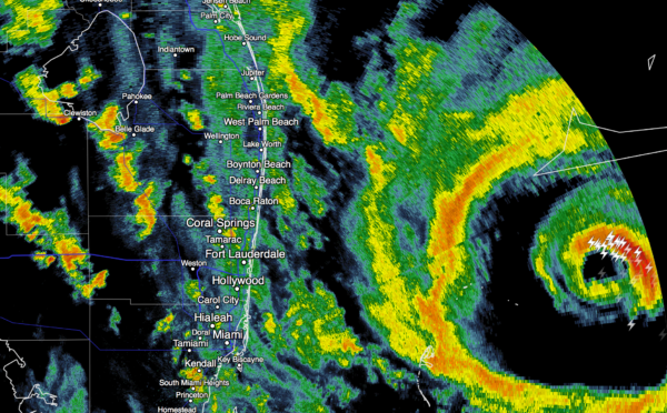
There is little change in thinking. The main concern is the coastal area from roughly West Palm Beach north to Daytona Beach; this is what can be expected there.
STORM SURGE: A surge of 7 to 10 feet is likely, which will bring coastal flooding and beach erosion. This will inundate low lying areas.
WINDS: Winds could gust to 125 mph, with potential to destroy mobile homes, bring structural damage, and widespread power outages which be of long duration, perhaps weeks in some cases. Windows in high rise buildings along the coast (condos, hotels, etc) could shatter due to flying debris.
RAIN: Amounts of 5 to 8 inches are likely along the immediate coast, with flooding likely.
TIMING: Conditions will deteriorate along the coast tonight; the worst of the weather will come from 3 a.m. until 12:00 noon tomorrow. The weekend will be calm with sunny weather Saturday and Sunday.
TO THE WEST: The impact will drop off on the “good” west side of the circulation center as you go farther inland. Orlando will deal with winds of 30-50 mph tomorrow (higher gusts are likely, however), with lots of rain, but probably not enough rain for widespread flooding. Disney World officials advised those at the Fort Wilderness campground to leave by 11 a.m. ET today; needless to say camping is not a good idea in these conditions. Disney World will be closed tomorrow; it reopens Saturday, when the sky should be mostly sunny. Tampa will see generally under 1/2 inch of rain, with winds under 30 mph.
TO THE NORTH: Matthew will impact Jacksonville, Savannah, and Charleston as well… storm surge flooding is likely along with some wind damage, but conditions there won’t be as extreme as the areas to the south.
Forecasting impact with a hurricane moving parallel to the coast is much more challenging that one moving into the coast at a perpendicular angle. A small deviation to the right or left will make a huge difference in impact, but in this case you have to prepare for a worst case scenario. Be sure and follow advice from local officials. Don’t fool around with this storm and take it lightly.
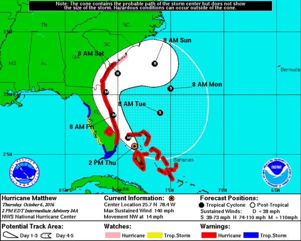
LOOPER: Matthew is expected to make a full loop in the Atlantic, and move back into South Florida early next week as a much weaker tropical storm.
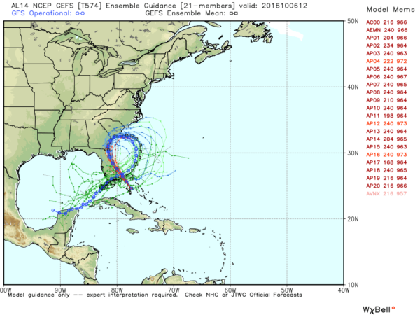
Looks like Matthew, or the “ghost of Matthew”, will wind up in the Southeast Gulf of Mexico by the middle of next week. It remains to be seen if it can strengthen there; long range global models are not especially bullish, but there is little skill in forecasting a tropical cyclone beyond five days.
WEATHER BRAINS: Don’t forget you can listen to our weekly 90 minute netcast anytime on the web, or on iTunes. This is the show all about weather featuring many familiar voices, including our meteorologists here at ABC 33/40.
CONNECT: You can find me on all of the major social networks…
Facebook
Twitter
Google Plus
Instagram
Look for the next Weather Xtreme video here by 7:00 a.m. tomorrow…
Category: Alabama's Weather
About the Author (Author Profile)
James Spann is one of the most recognized and trusted television meteorologists in the industry. He holds the AMS CCM designation and television seals from the AMS and NWA. He is a past winner of the Broadcast Meteorologist of the Year from both professional organizations.Subscribe
If you enjoyed this article, subscribe to receive more just like it.


