Another Big Rain Event Begins Tomorrow
COLD MORNING: Temperatures are below freezing in most places across North/Central Alabama early this morning; we expect another sunny day ahead with a high in the low 60s this afternoon. We stay above freezing tonight as clouds return.
WET, VERY COOL WEEKEND: Models continue to trend faster with the next weather system, and we will need to bring in a chance of rain tomorrow, maybe even starting tomorrow morning over the western counties of the state. The rain will slowly spread eastward during the day, otherwise tomorrow will be cloudy and cool with a high in the 50s.
Widespread rain is likely tomorrow night and Sunday; a warm front will remain over far South Alabama, so we stay in cool air. In fact, many communities north of Birmingham won’t get out of the 40s Sunday with rain falling.
STRONG STORMS EARLY NEXT WEEK? The warm front over South Alabama will lift northward during the day Monday, and there is a chance North Alabama could be in the “warm sector” of the storm by Monday night as a surface low develops and passes just northwest of here. The latest GFS run in house (06Z) shows dew points into the mid 60s as far north as I-20, so we will have potential for strong, maybe severe storms late Monday, Monday night, and very early Tuesday morning.
Rain and storms will end by mid-morning Tuesday as we get into a dry slot; some clearing is possible Tuesday afternoon with a high in the 60s.
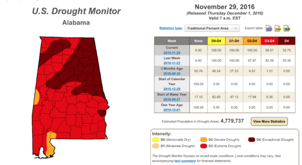
Rain totals from tomorrow through Tuesday morning are expected to be in the 3-4 inch range for much of Alabama; some spots could see even more. And, some flooding issues could crop up by Monday night. No, this won’t end the drought, but it will sure continue to put a dent in it. About a third of the state remains in an “exceptional” drought…
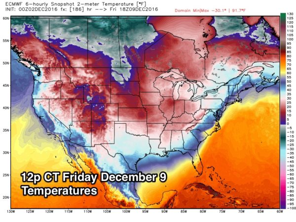
ARCTIC AIR BLAST LATE NEXT WEEK: The “gates to the Yukon” will open up next week, and very cold, Arctic air will flood much of the continental U.S. by Thursday and Friday. Looks like the Arctic front will come through, most likely, in dry fashion Wednesday, and we will go into the deep freeze after its passage.
We won’t get past the low 40s Thursday, and a strong north wind will make it feel much colder. Then, on Friday, the high will only in the upper 30s, and by Saturday morning most places around here have a good chance of dropping into the teens. Birmingham’s record low for December 10 is 13 set in 1995… I don’t think it gets that cold, but we should be within 5 degrees or so.
See the Weather Xtreme video for maps, graphics, and more details.
STORM SURVEYS: NWS Birmingham has identified 11 tornadoes so far from the severe weather event Tuesday night and Wednesday… NWS Huntsville survey teams have reported 6 tornadoes, for a total so far statewide of 17. That number could still go higher.
WEATHER BRAINS: Don’t forget you can listen to our weekly 90 minute netcast anytime on the web, or on iTunes. This is the show all about weather featuring many familiar voices, including our meteorologists here at ABC 33/40.
CONNECT: You can find me on all of the major social networks…
Facebook
Twitter
Google Plus
Instagram
I will be doing a weather program this morning at Oak Grove Elementary in Jefferson County… look for the next Weather Xtreme video here by 4:00 this afternoon. Enjoy the day!
Category: Alabama's Weather
About the Author (Author Profile)
James Spann is one of the most recognized and trusted television meteorologists in the industry. He holds the AMS CCM designation and television seals from the AMS and NWA. He is a past winner of the Broadcast Meteorologist of the Year from both professional organizations.Subscribe
If you enjoyed this article, subscribe to receive more just like it.


