Clouds Here, Rain Expected
.
Alabamians are waking up to a mostly cloudy morning with temperatures a trifle milder than the last several days with readings in the lower 40s for many locations. Temperatures were at or below freezing across the northeastern quadrant of Alabama. Radar continued to show some light rain over western counties and back into Mississippi. Much of that showing up on radar is not reaching the ground due to the deep dry layer in place from the ground to about 20,000 feet. This will be gradually changing as those echoes rain into that dry layer and gradually moisten it up from the top down. Rain is expected to begin affecting the ground especially across West Central Alabama during the early afternoon with rain spreading across the rest of Alabama late this afternoon and this evening.
For beachgoers, clouds return with rain for the beach this evening and these conditions stick around through the middle part of the week. Highs will be in the lower 70s through Monday dropping into the 60s after that. Lows will be in the 60s through Monday dropping into the 50s Tuesday and Wednesday. Please note that there is a high risk for rip currents along the Gulf Coast from Dauphin Island to Panama City through Sunday afternoon. See a very detailed Gulf Coast forecast here.
While the SEC Championship Game is indoors at the Georgia Dome set for a 3:00 pm CST start, conditions getting to and from the game will be dry today with temperatures in the upper 50s. Rain will spread into the Atlanta area shortly after the game ends and Sunday looks to be a cool and wet day there.
The 2016 Atlantic Hurricane Season ended this week. SPC has a marginal risk for severe weather along the Texas Coast today. No severe weather is expected in the US on Day 2, Sunday into early Monday. For Day 3, there is a slight risk of organized severe weather along the Louisiana, Mississippi, Alabama, and Northwest Florida coastal area with a marginal risk extending across the southern half of Alabama.
The upper air pattern featured a deep closed low and associated trough over Northwest Mexico this morning with ridging over the Southeast US. This was setting the stage with lots of Pacific moisture coming across Mexico and into the Southeast US. A second trough coming out of the Northwest US will contribute to a wet pattern for much of the Southeast US for Sunday and Monday. A surface low is forecast to move along the Gulf Coast during this period. The result will be a soaking rain with rainfall amounts of 2 to 4 inches across Mississippi and Alabama. Much of the northern half of Alabama should see amounts in the range of 2 to 3 inches.
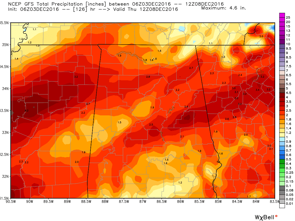
The upper trough/closed low over Northwest Mexico ejects to the northwest on Monday reaching the southern Appalachians by Tuesday. The surface low is forecast to be over East Tennessee by the GFS on Tuesday so the widespread precipitation should be coming to an end by Tuesday afternoon.
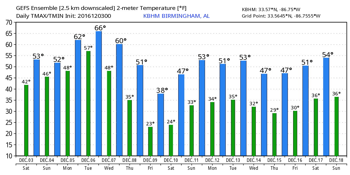
The forecast becomes a little less clear after midweek with substantial differences between the GFS and the ECMWF. The upper air pattern goes nearly zonal on Wednesday, but a strong trough is forecast by the GFS to dig into the mid Mississippi River Valley by Thursday. This sets up a general troughiness over the eastern half of the country for the latter half of the week. This should contribute some colder air to the eastern half of the US. But when it comes to precipitation, the models are quite a bit apart. The ECMWF is considerably more aggressive with precipitation on Thursday while the GFS is pretty dry. I suspect the actual result will be something between these two, so we’ll maintain some low chances for Wednesday and Thursday.
Both models agree on drying it out for the end of the week and into the weekend a cold surge for Friday and Saturday with highs potentially reaching only into the 40s.
Looking out into voodoo country, the GFS maintains a trough pattern across the eastern US all the way out to the 18th of December. And by that time, the GFS has a very deep trough with a distinctly frigid look to it.
Looking forward to emceeing the Helena Christmas Parade this afternoon at 1 pm. The reviewing stand will be in the parking lot of the Helena Baptist Church at the corner of Highway 52 and 261. Be sure to stop by and say hello. After that I will be filling in for Meaghan Thomas on ABC 3340 so you can the latest weather forecast at 6 and 10 pm. I expect to have the next Weather Xtreme Video posted here by 7:30 or so on Sunday morning.
-Brian-
Category: Alabama's Weather
About the Author (Author Profile)
Brian Peters is one of the television meteorologists at ABC3340 in Birmingham and a retired NWS Warning Coordination Meteorologist. He handles the weekend Weather Xtreme Videos and forecast discussion and is the Webmaster for the popular WeatherBrains podcast.Subscribe
If you enjoyed this article, subscribe to receive more just like it.


