Not as Cold, Rain Monday
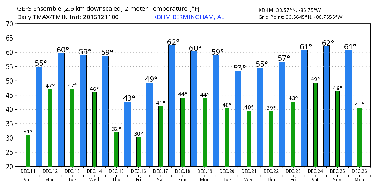
Alabamians once again waking up to clear skies over much of the state with temperatures about 6 to 8 degrees warmer than those of yesterday morning. The observer at Black Creek reported a low of 23 while most airport sites across Central Alabama were between 27 and 32 just before sunrise. The only exception to those clear skies was in the southeast corner of the state where low clouds had invaded the sky and temperatures bottomed out around 40. The sky will gradually fill with clouds later today as the next system and cold front approach Central Alabama. Look for highs in the middle 50s. And tonight temperatures will not fall very far from the highs as southerly flow kicks into high gear along with clouds as rain chances ramp up quickly during the early morning hours.
For beachgoers, you’ll have a partially sunny day today along the beach of Alabama and Northwest Florida with highs a bit warmer in the middle 60s. Temperatures warm up to around 70 for the period from Monday to Wednesday, however, there will be daily chances of rain with mostly cloudy skies. You can find the detailed beach forecast here.
No severe weather is anticipated anywhere across the United States. A peal or two of thunder may be heard as the air mass destabilizes a little along and just ahead of the approaching cold front.
The upper flow goes nearly zonal for the next few days – at least through Wednesday. That keeps our weather somewhat unsettled with the front stalled out in our area. The frontal boundary together with several weak waves along the front will keep rain chances fairly high for Monday and Tuesday but tapering off into Wednesday. Highs will climb back to around 60 which is a few degrees warmer than the 30-year averages for this time of year. Morning lows won’t fall back very far, either, with lows in the vicinity of 50 degrees. Rainfall is still expected to be in the range of one half to about one inch for much of the state, continuing to help reduce the drought conditions for us.
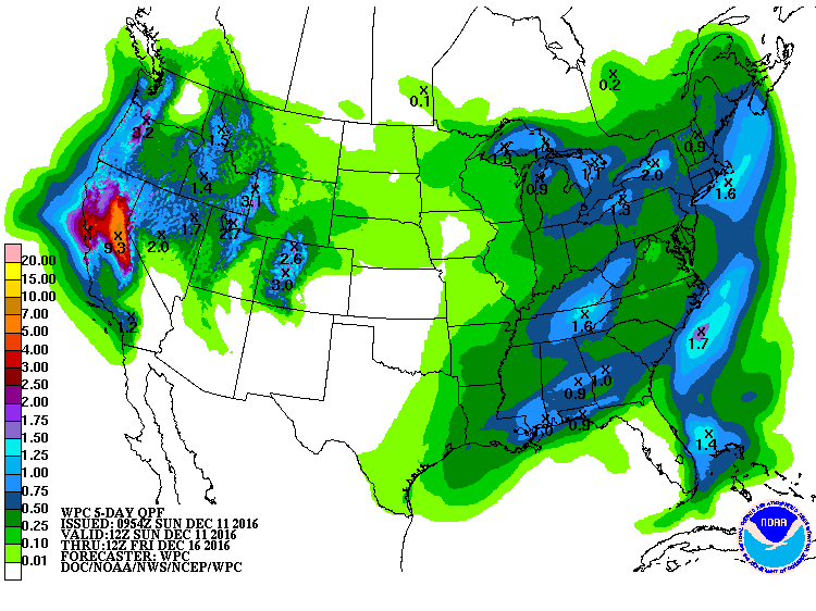
The upper flow takes on a general troughiness over the eastern US with a strong trough moving from the Great Lakes area Wednesday into eastern Great Lakes Thursday. This should be enough to push the front and the rain chances further south allowing us to dry out and chill down again on Thursday. We will be in the lower 40s for highs on Thursday with morning lows the coldest Friday morning as we drop back briefly into the 20s.
We come under ridging Friday and into Saturday with our temperatures warming quickly with lows getting back into the 40s and highs in the lower 60s. But clouds will also be on the increase Saturday as the next system approaches us with promises of rain once again on Sunday. Moisture increases with a good southerly surface flow Saturday into Sunday with moisture aloft coming out of the Pacific. Clouds and rain Sunday will hold temperatures down a bit with highs in the 50s.
Everything points to a rather active period as we look out into voodoo country. The upper flow establishes a ridge over us for the 20th of December with a deep trough/closed low over the Soutwest US. That close low ejects eastward across the Lower Mississippi River Valley on the 21st. This strong trough could produce a round of severe weather for the southern US for the 21st and 22nd. By the 26th of December, the upper air pattern features a trough along the eastern slope of the Rockies keeping the eastern half of the country fairly warm with southwesterly flow aloft. But this pattern would also favor a relatively wet and stormy period, too, potentially providing the Southeast US with a wet Christmas.
James Spann will be back with the next edition of the Weather Xtreme Video first thing on Monday morning. I’m filling in for Meaghan Thomas once again this evening, so you can catch up on the latest forecast on ABC 3340 News at 5 and 10 pm. I’m also looking forward to talking to a group of folks at the Agricultural Extension Service on Monday evening discussing our drought pattern. Have a great day and Godspeed.
-Brian-
Category: Alabama's Weather
About the Author (Author Profile)
Brian Peters is one of the television meteorologists at ABC3340 in Birmingham and a retired NWS Warning Coordination Meteorologist. He handles the weekend Weather Xtreme Videos and forecast discussion and is the Webmaster for the popular WeatherBrains podcast.Subscribe
If you enjoyed this article, subscribe to receive more just like it.


