Rain At Times Today; Much Colder Thursday
FOGGY START: A dense fog advisory is in effect for parts of Alabama early this morning; visibility is down to just a fraction of a mile in spots, especially east of I-65, so take it easy out there heading in to work. The fog is north of a slow moving warm front over Central Alabama.
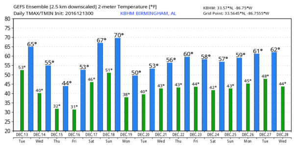
We will continue to forecast a few periods of light rain today with a cloudy sky; temperatures will rise into the mid 60s this afternoon; communities down in South Alabama will go back into the 70s. Rain amounts will be mostly 1/4″ or less for North Alabama, with up to 1/2″ to the south.
TOMORROW: It will be a cool, dry day. The sky becomes partly sunny, and the high will be in the 55-59 degree range.
COLD AIR RETURNS THURSDAY/FRIDAY: We expect sunshine in full supply Thursday and Friday, but temperatures will be sharply lower. We won’t get past the mid 40s Thursday, and by Friday a freeze is likely with most places seeing a low in the 20s. The high Friday afternoon will stay in the chilly 40s.
WEEKEND RAIN: More fast paced weather changes are ahead for the weekend; moisture returns Saturday as a strong southerly flow develops, and showers will begin to form during the day. I don’t think I would call Saturday a “rainy day”, but no doubt showers are certainly possible, especially over the northern counties of the state. The high will be up in the mid 60s.
Rain will increase Saturday night with the approach of a cold front.
Sunday promises to be an interesting weather day. The air will be unstable over the southern half of the state, where strong storms are possible. In fact, a severe storm can’t be totally ruled out. For now it looks like the main window for strong storms over Central and South Alabama will come from about 2:00 a.m. until 12:00 noon Sunday.
And, while that is going on, a cold front will pass through North Alabama bringing falling temperatures. As the rain tapers off and the cold air rushes in, we might even see a few snow flurries over the Tennessee Valley of far North Alabama. We expect NO impact if a snow flake or two falls. At midday Sunday it could very well be in the mid to upper 30s near the Tennessee border, with 70s over far South Alabama.
On the positive side rain amounts of about one inch look likely this weekend.
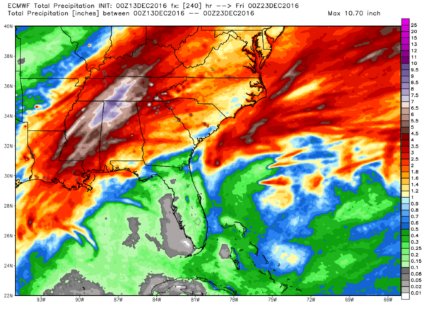
NEXT WEEK AND BEYOND: Monday looks cool and dry, but rain could return to the state as early as Tuesday. And, looking out toward Christmas, it looks like temperatures will be near average for late December (highs in the 50s) with occasional opportunities for rain. The European model is suggesting some beneficial rain for much of the state over the next ten days…
Again, for now no sign of any high impact snow or ice event for Alabama over the next 15 days.
WEATHER BRAINS: Don’t forget you can listen to our weekly 90 minute netcast anytime on the web, or on iTunes. This is the show all about weather featuring many familiar voices, including our meteorologists here at ABC 33/40. Scroll down for the show notes on the new episode we recorded last night.
CONNECT: You can find me on all of the major social networks…
Facebook
Twitter
Google Plus
Instagram
I am speaking at a senior adult event this morning in Oxford, and the annual Toys for Tots marathon continues today; I will be live at the McDonalds on US 31 in Hoover, across from the Galleria, at 4, 5, and 6:00 on ABC 33/40 News this afternoon. Enjoy the day!
Category: Alabama's Weather
About the Author (Author Profile)
James Spann is one of the most recognized and trusted television meteorologists in the industry. He holds the AMS CCM designation and television seals from the AMS and NWA. He is a past winner of the Broadcast Meteorologist of the Year from both professional organizations.Subscribe
If you enjoyed this article, subscribe to receive more just like it.


