A Late Midday Look At Central Alabama’s Weather
A Gloomy Looking Day With Sprinkles And Light Rain At Midday
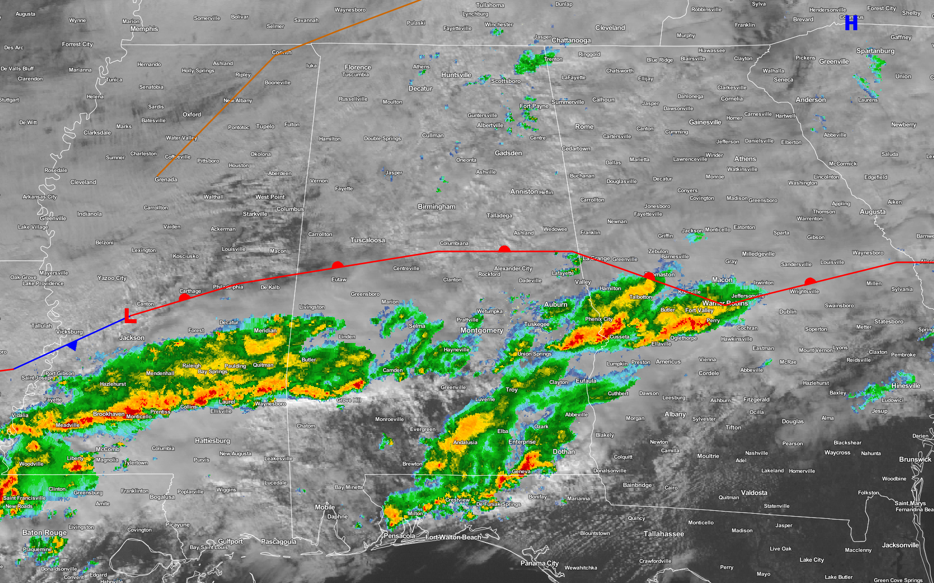
At 1:15PM, a warm front has moved from the extreme southern counties of the state up into Central Alabama. It is currently located over Moundville to Calera to Wadley, and is forecasted to stay near to where it is before being pushed back to the south and east as an approaching cold front will be bringing cooler and drier air behind it. A line of showers and a few thunderstorms are located just ahead of the warm front down in the extreme southern parts of the area along and south of US-80 and I-85. For the rest of the area north of the front, just a few spots with sprinkles or light showers at the moment.
It looks like for the remainder of the day, the line of showers and storms will move eastward while any chance of decent rainfall for the northern 2/3rds of the area have pretty much been cut off. Afternoon highs will be in the upper 50s to mid 60s north of I-20, with mid 60s to near 70 south of that. As the cold front gets closer to the area, colder and drier air will push in to the northwest corner. Rain chances will drop from the northwest to the southeast during the evening and overnight hours. Best chances for decent rainfall will be south of the US-80 and I-85 corridors, with overnight lows dropping into the 30s west of I-59 and I-20/59, with 40s south of that to just north of US-80 and I-85, and 50s south of that.
Current Temperatures Across Central Alabama
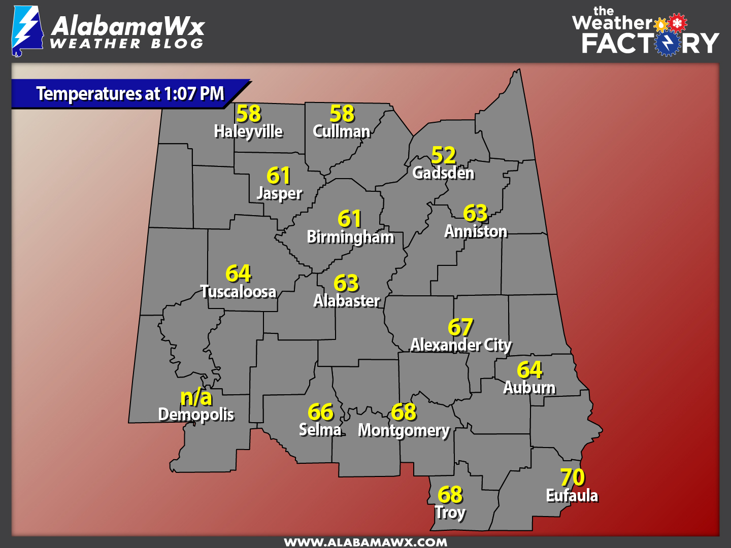
At this time, temperatures are currently ranging from the 50s in the extreme northern parts of the area to the 60s in the southern parts of the area. Warm spot is currently Eufaula at 70 degrees, while Gadsden is currently the cool spot at 52 degrees.
Birmingham’s Climatology And Records
The normal high for December 13th is 56, while the normal low is 36. The record high for today was set back in 1931 at 79 degrees. The record low was set back in 1962 at 1 degrees.
Skies Slowly Clears For Wednesday
The cold front will have pushed through the area, and winds will be out of the north. The good news is that the coldest air will have not arrived, so temperatures will be close to normal for this time of the year. Skies will be mostly cloudy to start off with and will start to clear out a little during the afternoon hours, and becoming mostly clear by the time dinner time arrives. Highs will be in the 50s for most, with a few 60s in the south. The colder air starts to really push in after sunset, and overnight lows will drop down into the 30s for most, with a few 20s possible in the colder spots, and near to just over 40 degrees in the south.
National Extremes
Marathon, Florida recorded the warmest high temperature for Monday at 87 degrees. The coldest low temperature for last night into the early morning hours today was recorded 8 miles south of Ulm, Montana at -21 degrees.
On This Day In Weather History: 1962
A severe Florida freeze occurred. Morning lows reached 35 degrees at Miami, 18 degrees at Tampa, and 12 degrees at Jacksonville. It was the coldest December weather of the 20th century and caused millions of dollars damage to crops and foliage. In Georgia, the morning low of 9 degrees below zero at Blairsville established a state record for the month of December.
Follow The Blog On Social Media
The blog is now on Facebook, so be sure to head over there, click the like and follow buttons to stay up-to-date with the latest info from your favorite meteorologists. Also, be sure to follow the Alabama Wx Weather Blog on Twitter. Just click here to start following our feed.
WeatherBrains
This is the weekly netcast that’s all about weather featuring many familiar voices, including our meteorologists at ABC 33/40. You can listen anytime on the web, or on iTunes. You can find it here.
Forecaster: Scott Martin (Twitter: @scottmartinwx)
Category: Alabama's Weather
About the Author (Author Profile)
Scott Martin is an operational meteorologist, professional graphic artist, musician, husband, and father. Not only is Scott a member of the National Weather Association, but he is also the Central Alabama Chapter of the NWA president. Scott is also the co-founder of Racecast Weather, which provides forecasts for many racing series across the USA. He also supplies forecasts for the BassMaster Elite Series events including the BassMaster Classic.Subscribe
If you enjoyed this article, subscribe to receive more just like it.


