

Arctic Air Arrives Tonight; Warmer, Stormy Weekend
HERE COMES THE COLD: The sky has cleared over the northern half of Alabama this afternoon, with clouds lingering over the southern counties of the state. An Arctic front will pass through this evening in dry fashion, and will put us in the deep freeze for 48 hours. Despite a sunny sky, we won’t get past the low to mid 40s tomorrow afternoon, and temperatures drop into the mid 20s early Friday morning.
A warming trend will begin Friday afternoon with a partly sunny sky; most communities will see a high in the mid 50s.
WILD WEEKEND WEATHER SWINGS: Temperatures will warm into the low 70s Saturday afternoon with a stiff southerly breeze, and with increasing moisture levels look for developing showers during the day.
Then, with the approach of an Arctic front, we have potential for two radically different issues Saturday night and Sunday.
STRONG TO SEVERE STORMS: SPC has defined a severe weather risk for parts of West and Northwest Alabama for late Saturday night and early Sunday morning; it includes places like Muscle Shoals, Hamilton, Jasper, Tuscaloosa, and Demopolis…
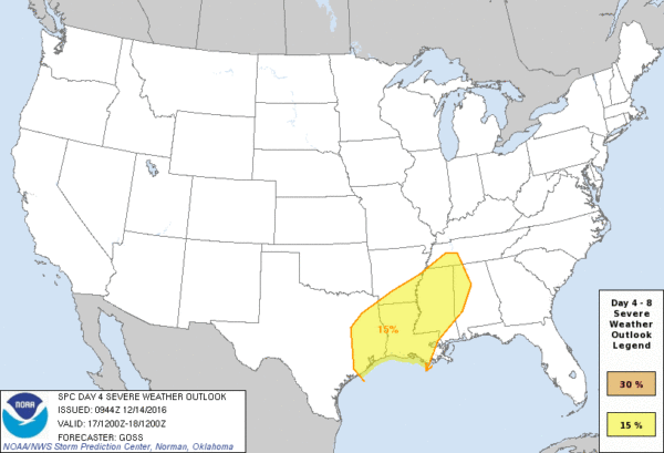
Dewpoints will surge into the 60s Saturday night, making for a rather unstable airmass. Surface based CAPE values rise to levels over 500 j/kg as well, and with a decent amount of shear we will need to be watching for strong to severe storms from about 8:00 p.m. Saturday through 8:00 a.m. Sunday. Core risk of severe storms will be west of I-65.
Storms during this 12 hour window will be capable of producing hail, strong gusty winds, and even some risk of an isolated tornado or two. We will be able to fine tune this risk as the weekend gets closer.
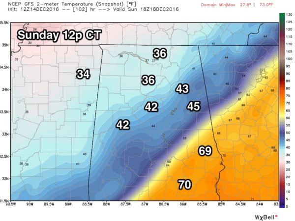
WINTRY MIX? Sunday will be a day with temperatures going the wrong way. If you are in a place like Birmingham, Tuscaloosa, Anniston, or Gadsden, you might wake up early in the day with temperatures not far from 70 degrees, high dewpoints, and a “balmy” feel to the air. But, temperatures will fall sharply during the day in the wake of the Arctic front, reaching the 30s by Sunday afternoon with a brisk north wind.
There is some chance rain could change to a light mix of sleet and freezing rain over the northern quarter of Alabama Sunday before it all ends. But, as discussed here in recent days, we expect no impact if this happens…
*The new run of the GFS model (12Z) is coming in line with the European model, suggesting little if any wintry precipitation as the rain ends Sunday over North Alabama.
*If any sleet or freezing rain happens to form, it won’t last long at all.
*The infrastructure will be warm from Saturday’s southerly flow.
We will keep a close watch on conditions as we get close to the weekend.
NEXT WEEK: For now the weather looks cold and dry Monday and Tuesday, then rain returns toward the end of the week with a warming trend. No evidence of any extreme cold, snow, or ice issues around the Christmas weekend. See the Weather Xtreme video for maps, graphics, and more details.
WEATHER BRAINS: Don’t forget you can listen to our weekly 90 minute netcast anytime on the web, or on iTunes. This is the show all about weather featuring many familiar voices, including our meteorologists here at ABC 33/40.
CONNECT: You can find me on all of the major social networks…
Facebook
Twitter
Google Plus
Instagram
Look for the next Weather Xtreme video here by 7:00 a.m. tomorrow…
Category: Alabama's Weather
About the Author (Author Profile)
James Spann is one of the most recognized and trusted television meteorologists in the industry. He holds the AMS CCM designation and television seals from the AMS and NWA. He is a past winner of the Broadcast Meteorologist of the Year from both professional organizations.Subscribe
If you enjoyed this article, subscribe to receive more just like it.


