Complex Forecast for First of 2017
Strap on your seat belts! The forecast for the start of 2017 looks complicated and is likely to feature something for everyone ranging from sunshine to thunderstorms to wintery precipitation.
Clouds increased across the Southeast US overnight as good Pacific moisture began to be pumped into the area as the upper flow began to take on a more southwesterly character. The surface flow was also beginning to go southerly picking up low level moisture from the Gulf of Mexico. Temperatures were all over the board this morning ranging from 32 at Fort Payne to 48 at Mobile. Flash flood watches were issued for portions of Southeast Louisiana, southern Mississippi, Southwest Alabama, and extreme western sections of the Florida Panhandle in anticipation of the multi-day rain event that we’ve been forecasting.
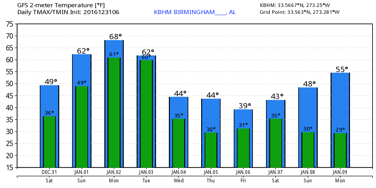
While temperatures near the ground are warm, the temperature/moisture profile of the lower portion of the atmosphere still supports the potential for precipitation to begin as light sleet. Radar showed numerous patches of light rain in Alabama with almost no observation sites reporting rain at the ground. The dry layer near the ground will allow some evaporative cooling thus the potential for some light sleet as the column moistens up. But by this afternoon the temperature/moisture profile will have moderated with all precipitation coming in the form of rain. It will be chilly today with highs climbing only into the lower 50s.
Weather will not affect either the Alabama or the Auburn games since both are being played inside domed stadiums. But you may need some rain gear going and coming from the games. Alabama faces the Washington Huskies in the Georgia Dome this afternoon at 2:00 pm. The day looks cloudy with rain expected to move into northern Georgia during the evening hours. High will be near 50 in Downtown Atlanta. Auburn goes against the Oklahoma Sooners in New Orleans in the Super Dome on Monday evening at 7:30 pm. Weather looks rather warm, wet, and unsettled with showers and thunderstorms likely and temperatures in the middle 70s.
If your plans include the beach, cloudy skies are forecast together with multiple chances of rain for the weekend and into the beginning of next week. High temperatures will be in the upper 60s today climbing into the lower 70s Sunday and into the first several days of next week. See the complete Gulf Coast 7-Day Planner here.
The upper flow becomes decidedly southwesterly Sunday as a deep trough and a closed low did into Northwest Mexico south of the Four Corners area. This just keeps the flow of Pacific moisture coming into the Southeast US, so Sunday will be a wet day with rain off and on. Some peals of thunder are possible Sunday as well with the best chances for severe weather across the eastern two-thirds of Texas.
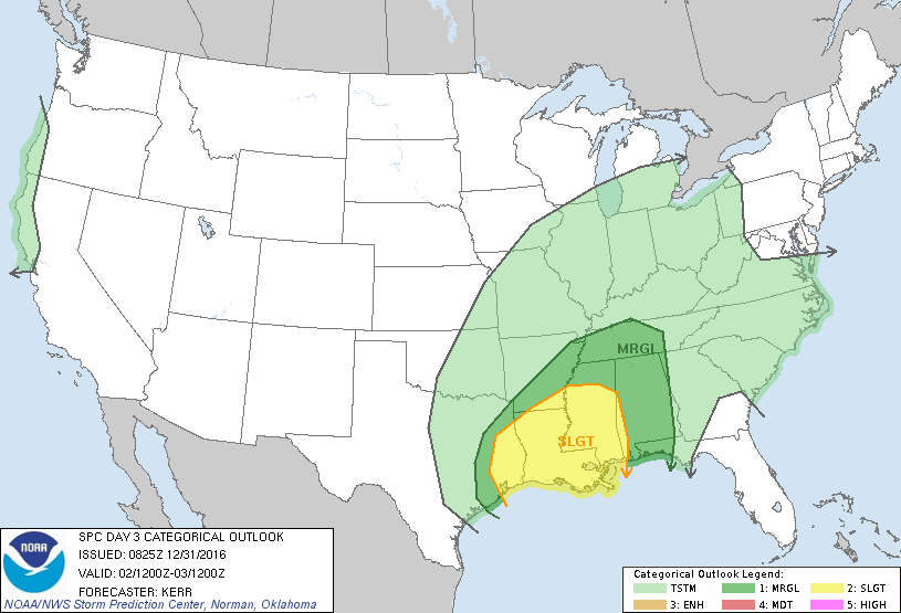
The upper flow stays southwesterly into Monday as the closed low comes out across East Texas as an open trough. The surface low will be in Northwest Kansas with a front pushing across the Lower Mississippi River Valley. SPC has the standard slight risk area across a large portion of Mississippi, most of Louisiana, East Texas, and a small sliver of Alabama from the West Central counties to Mobile. CAPE values are forecast to near 2000 j/kg over the slight risk area along with helicity values in the 200-300 range. SPC may adjust this area in future updates, so we’ll have to watch carefully to see if there will be any impact on North and Central Alabama.
Tuesday the upper trough zips well northeast of us and the surface front moves into Georgia, so Tuesday will be a transition day as we dry out with precipitation ending from the west. Monday and Tuesday should be fairly warm days with a strong southerly flow so highs will be well into the 60s. GFS MOS guidance suggests we could reach the 70s on Monday, but I’m not as optimistic as MOS is since we’ll have showers and thick clouds around.
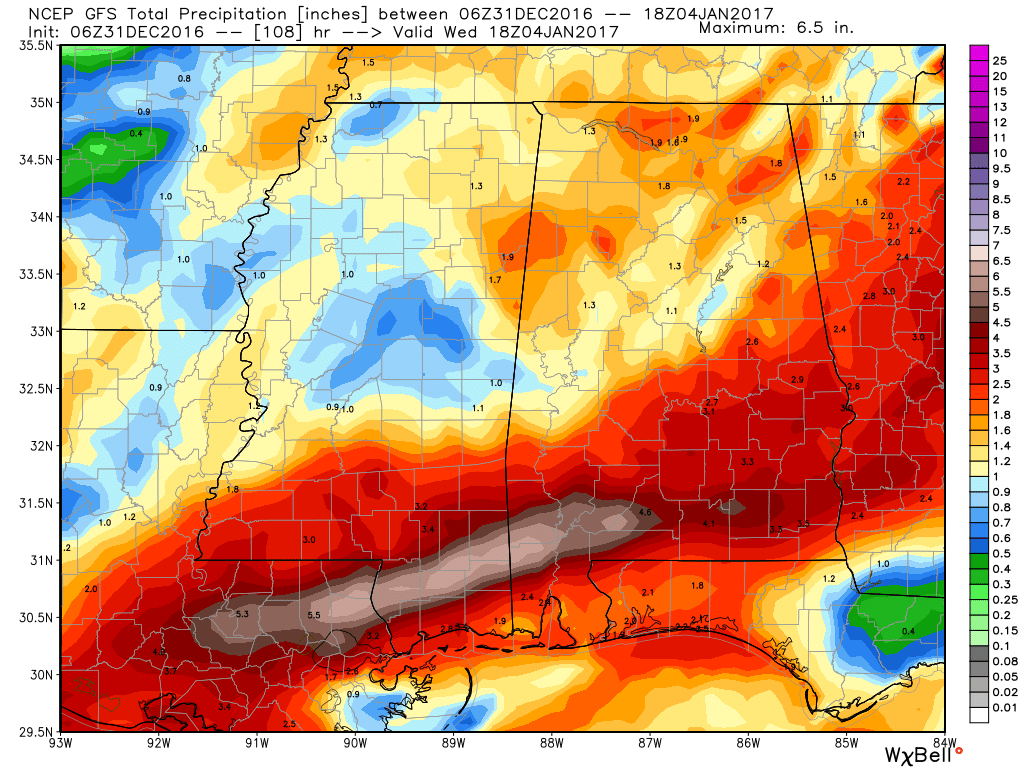
Rainfall during the five-day period ending Thursday morning will be in the 2 to 4 inch range across North and Central Alabama with amounts of 4 to 7 inches possible from Dothan westward across Mobile and into the southern half of Louisiana.
Wednesday and Thursday will be somewhat nondescript days with partly cloudy skies and temperatures kept on the chilly side with a surface high off to our northwest. Highs will be a bit cooler than typical for early January with highs in the 40s and lows in the 30s.
Friday is shaping up to be a challenging day for forecasters. The ECMWF and the GFS are completely our of phase with each other, so confidence on the forecast for the end of the week and into the weekend is not terribly high. Unfortunately, the normally stable ECMWF has been flipping dramatically between runs while the GFS has maintained at least some continuity, so for now I’m going with the GFS. A short wave moves across the Central US on Friday and into Saturday. This is forecast to set up a broad low in the Gulf as colder air to the north sinks southward. As the GFS did yesterday, it is suggesting a band of sleet and light snow across northern portions of the Southeast US on Friday. The best chances for any snow will be across the Tennessee River Valley and northern third of Mississippi. It is much too early to be able to say whether or not this could create any travel issues particularly because our ground temperatures are so warm. But as we all know all too well, those exposed elevated roadways and bridges will respond differently. So this situation definitely falls in the category of careful watching.
By Saturday the upper trough moves eastward sweeping the clouds and precipitation with it but leaving us somewhat chilly with highs in the 40s.
Looking out into voodoo country, the GFS has gone quite bullish on the return of the upper ridge over the Gulf and Bahamas. This would definitely suggest some milder weather for the Southeast US.
I’ll be helping to handle the weather duties on ABC 3340 this weekend, so you can watch at 6 and 10 pm today for the latest forecast information. I hope you have a great day. Godspeed.
-Brian-
Category: Alabama's Weather
About the Author (Author Profile)
Brian Peters is one of the television meteorologists at ABC3340 in Birmingham and a retired NWS Warning Coordination Meteorologist. He handles the weekend Weather Xtreme Videos and forecast discussion and is the Webmaster for the popular WeatherBrains podcast.Subscribe
If you enjoyed this article, subscribe to receive more just like it.


