Three Weather Issues Ahead
Here is a quick look at the three issues facing Alabama over the next week…
WEEKEND RAIN: A good rain event will unfold this weekend with rising moisture levels, isentropic lift, and an approaching wave aloft.
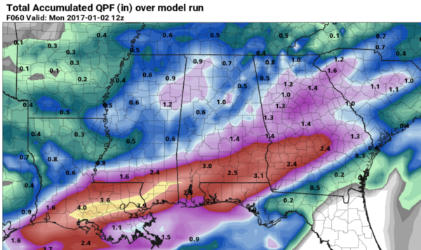
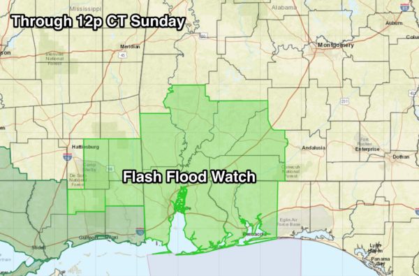
As you can see, the heaviest rain should fall over South Alabama, where the NWS Mobile has issued a flash flood watch for seven Alabama counties, and Escambia County in Florida (including Pensacola)…
There will be breaks in the rain, but this looks like a very wet New Years weekend for most of Alabama.
SEVERE STORM POTENTIAL MONDAY INTO EARLY TUESDAY: Warm, unstable air will move northward during the day Monday ahead of another wave to the west, and by Monday afternoon dewpoints will be in the 60s well into North Alabama. This will make the air unstable, and set the stage for the chance of strong to severe storms. SPC has most of the state in a “marginal” severe weather risk, with a more significant “slight” risk over far West and Southwest Alabama.
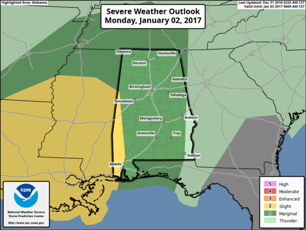
Just too early to resolve the mesoscale details that will determine the severity of the threat for now, but these cold season systems can be very tricky to deal with. Looks like a classic “low CAPE, high shear” event we see this time of the year. Limited instability, but good veering of the wind with altitude. Looks like strong to severe storms could be possible from Monday afternoon well into Monday night and early Tuesday morning.
WINTER MISCHIEF LATE IN THE WEEK? Much colder, Arctic air will settle into Alabama Thursday and Friday, and with a broad southwest flow aloft with potential for embedded waves, that sets the stage for some potential for wintry precipitation somewhere across the southern U.S.
As usual, there is complete model madness for now. Best way to deal with this is to use the ensemble approach; this is model output using multiple runs (or members), with each using a slightly different set of initialization conditions. The collection of different runs from the series of initialization “tweaks” is called an ensemble.
Output from the GEFS (global ensemble forecast system with 21 members) still suggests some potential for wintry precipitation (snow, sleet, or freezing rain) across the southern U.S. in the January 5-7 time frame…
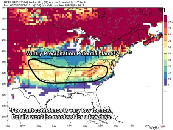
There is absolutely no way to resolve the details on this; some in this zone could very well see some sleet, freezing rain, or snow, but others will see just a cold rain, and some will get nothing.
Why share the idea at all? Because we are within 7 days of the event, where there is some forecast skill. And, it is our job to give you the range of possibilities out to seven days. We really need to get past the severe weather threat Monday night before we can have a good grasp on this; just something to watch for now.
As always, keep an eye on the blog for details on these three events…
Category: Alabama's Weather
About the Author (Author Profile)
James Spann is one of the most recognized and trusted television meteorologists in the industry. He holds the AMS CCM designation and television seals from the AMS and NWA. He is a past winner of the Broadcast Meteorologist of the Year from both professional organizations.Subscribe
If you enjoyed this article, subscribe to receive more just like it.


