Winter Weather Ahead For Alabama Tomorrow
**No afternoon Weather Xtreme video today due to extremely heavy radio/TV/social media duties; the blog discussion will explain it all nicely**
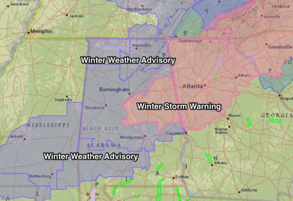
WINTER STORM AHEAD: NWS offices in Alabama have issued winter storm warnings and winter weather advisories this afternoon that will be in effect tomorrow, tomorrow night, and early Saturday morning for much of the state…
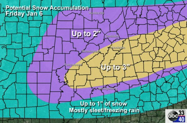
AMOUNTS: Understand the “accumulation potential” map below is just a guideline, and “up to 3 inches” means a range of zero to 3. Not everybody will get accumulating snow in these colored bands; we prepare these maps simply as a guideline. Some will get 2-3″ of snow, others will get nothing.
TIMING: Light snow and sleet could begin across the northern half of Alabama as early as 6:00 tomorrow morning along and west of I-65.. Initially the precipitation will be light, but temperatures will be below freezing, and bridge icing is very possible. This will move into East Alabama tomorrow afternoon. Understand the snow/sleet during the day tomorrow should be relatively light, but many communities will remain below freezing much of the day, and icing will remain possible on bridges and overpasses.
Rain is likely over South Alabama during the day tomorrow.
Tomorrow night, after 5:00 p.m., precipitation rates will increase, with heavier snow/sleet for Central Alabama. This is when driving conditions will begin to deteriorate significantly as temperatures drop into the 20s after dark. Rain will change over to sleet and snow over South Central Alabama later tomorrow night, especially after midnight.
Precipitation will end early Saturday morning.
POWER: Widespread power outages are not expected since in most places the snow will be light, and winds won’t be especially high.
TRAVEL ISSUES: The main issue involves travel. As stated above, icy bridges are possible during the day tomorrow, but all roads could become icy, especially in the winter storm area, tomorrow night as temperatures drop into the 20s and precipitation gets heavier. Travel where heavier snow falls will become difficult, if not impossible, late tomorrow and tomorrow night. We could see icy travel even south of U.S. 80 after midnight tomorrow night and early Saturday morning.
While the snow will end early Saturday, icy roads could linger through at least mid-day with very cold air lingering over Alabama. Conditions begin to improve Saturday afternoon.
BIRMINGHAM-SHUTTLESWORTH AIRPORT: Snow could mean potential for flight delays or reduced operation, mainly tomorrow afternoon and tomorrow night into early Saturday morning.
ATLANTA: Operations at Hartsfield Airport in Atlanta could be seriously disputed Saturday; Atlanta is under a winter storm warning where snow amounts could exceed two inches easily. Expect flight delays, maybe even some cancellations. Driving in Atlanta is NOT advised Saturday.
REST OF THE SOUTHEAST: Snow will move into Georgia and the Carolinas Saturday, heavy in spots, making for very difficult driving conditions.
FRIGID WEEKEND: Very cold air will linger across Alabama over the weekend; the high Saturday will be only in the mid 30s, followed by upper 30s Sunday. We drop into the 15-20 degree range early Sunday and Monday morning. The sky becomes partly sunny Saturday, and Sunday will feature sunshine in full supply.
NEXT WEEK: The weather will be warmer with a chance of rain by Tuesday night and Wednesday.
WEATHER BRAINS: Don’t forget you can listen to our weekly 90 minute netcast anytime on the web, or on iTunes. This is the show all about weather featuring many familiar voices, including our meteorologists here at ABC 33/40.
CONNECT: You can find me on all of the major social networks…
Facebook
Twitter
Google Plus
Instagram
Keep checking the blog for updates tonight and through the event tomorrow…
Category: Alabama's Weather
About the Author (Author Profile)
James Spann is one of the most recognized and trusted television meteorologists in the industry. He holds the AMS CCM designation and television seals from the AMS and NWA. He is a past winner of the Broadcast Meteorologist of the Year from both professional organizations.Subscribe
If you enjoyed this article, subscribe to receive more just like it.


