Winter Storm Warning & Winter Weather Advisory Now Up For Central Alabama
The National Weather Service has just issued the upgrades to the Winter Storm Watch.
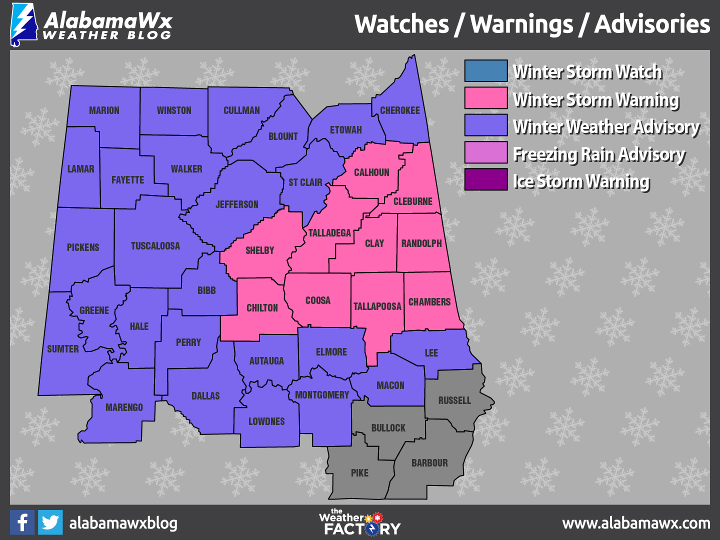
Here are the details:
…Winter Storm Warning for Calhoun, Chambers, Chilton, Clay, Cleburne, Coosa, Randolph, Shelby, Talladega and Tallapoosa Counties.
…Winter Weather Advisory for Bibb, Blount, Cherokee, Etowah, Jefferson, Pickens, St. Clair, Tuscaloosa and Walker Counties. .
…Winter Weather Advisory for Autauga, Dallas, Elmore, Greene, Hale, Marengo, Perry and Sumter Counties.
…Winter Weather Advisory for Fayette, Lamar, Marion and Winston Counties.
…Winter Weather Advisory for Lee, Lowndes, Macon and Montgomery Counties.
TIMING
The Advisory begins officially at 6 a.m. CST tomorrow morning (Friday) and continues until 9 a.m. Saturday morning. Precipitation will begin over South Alabama early tomorrow morning and rapidly increase after noon tomorrow across much of Central Alabama.
IMPACTS STILL UNCERTAIN
There are still significant differences in the two main models that we use as far as the amount of moisture and strength of this system. The two solutions are very different, with the GFS showing a swath of light snow across North Alabama, with a wintry mix of snow, sleet and freezing rain depending on your location basically between I-20 and I-65/85.
Here is the current thinking behind the Advisory, with a lean to the GFS, but an eye on the European and the uncertainty it brings to the table.
RAIN
It will fall as all rain over South Alabama, generally south of a line from Citronelle to Evergreen to Troy to Phenix City. No problems expected here.
MIX OF FREEZING RAIN AND SLEET
North of that line, to a line from Livingston to Verbena to Roanoke, there may be a significant accumulation of sleet and freezing rain. We aren’t talking about an ice storm on the order of 1982, but there will be ice accumulations, including 0.1 to 0.2 inches of freezing rain and 0.25 to 0.5 inches of sleet. This can cause significant travel problems and some power outages. I don’t think we are paying enough attention to the icing threat across the Central part of Alabama. It doesn’t take much freezing rain and sleet to cause real problems.
SNOW
A decent accumulating snow may affect a swath generally along and south of I-59 back down to a line from Butler to Selma to Wetumpka to Auburn and Valley. Accumulations in this area could be in the 1-3 inch range with some places picking up 3-6 inches. There will be some disappointed people who are on the low end, which there will be some surprises on the high side too. The best chance for the higher accumulations will be over parts of Clay, Randolph, Coosa, Tallapoosa and Elmore Counties. Over North Alabama, a general dusting to 1 inch will occur. A few counties like Pickens, Fayette and Walker could get left out though.
PRECIPITATION TIMING
…First light rain will reach Southwest Alabama between 9 pm-midnight tonight.
…The arctic front should reach I-59 by Sunrise
…Light snow should move into Northwest Alabama during the morning hours.
…Precipitation will begin to increase over Southwest Alabama by noon.
…Precipitation will be heaviest between 2 p.m. and 9 p.m., tapering after that from the west
…The best chances for precipitation will continue until the pre-dawn hours Saturday
…Most of the precipitation will be gone by 6 a.m. Saturday.
SCHOOL, WORK TOMORROW?
If confidence in this forecast scenario continues to increase, I would expect many school systems across the area to cancel tomorrow. Those decisions might not come until early Friday morning however for many. Jefferson County schools have already announced that they will be closed tomorrow.
TIMING OF TRAVEL PROBLEMS
…Freezing rain could begin over West Central Alabama’s Sumter, Choctaw, Marengo Counties by mid-morning, increasing into the noon hour.
…Light snow will begin falling during the afternoon, perhaps as early as 1-2 p.m. just south of the I-20 Corridor with sleet across the northern part of the advisory area through the afternoon.
…Snow will increase south of the I-20 Corridor through the evening with sleet and freezing rain spreading south across the Advisory area through the evening.
STILL A CHANGING FLUID SITUATION
As is often the case, we won’t know what is really going to happen until we see the whites of this system’s eyes, and that will come early tomorrow morning mostly likely. Stay tuned here for the very latest updates throughout the afternoon, overnight and the event itself. James will have his thoughts just after 3 p.m.
Category: Winter Weather
About the Author (Author Profile)
Scott Martin is an operational meteorologist, professional graphic artist, musician, husband, and father. Not only is Scott a member of the National Weather Association, but he is also the Central Alabama Chapter of the NWA president. Scott is also the co-founder of Racecast Weather, which provides forecasts for many racing series across the USA. He also supplies forecasts for the BassMaster Elite Series events including the BassMaster Classic.Subscribe
If you enjoyed this article, subscribe to receive more just like it.


