Severe Thunderstorm Warning Canceled For Parts Of Lowndes County
…THE SEVERE THUNDERSTORM WARNING FOR EASTERN LOWNDES COUNTY IS CANCELLED…
The storm which prompted the warning has weakened below severe
limits, and no longer pose an immediate threat to life or property.
Therefore the warning has been cancelled.
A tornado watch remains in effect until 300 AM CST for south central
Alabama.
Severe Thunderstorm Warning Continues For Parts Of Lowndes County Until 1130 PM CS
Jan 21st @ 9:01 am
At 1101 PM CST, a severe thunderstorm was located over Beechwood, or
near Hayneville, moving northeast at 60 mph.
HAZARD…Quarter size hail.
SOURCE…Radar indicated.
IMPACT…Damage to vehicles is expected.
Locations impacted include…
Mosses, Hayneville, Gordonville, Beechwood, Mount Willing and
Letohatchee.
Severe Thunderstorm Warning Issued For Parts Of Lowndes County
Jan 21st @ 9:01 am
The National Weather Service in Birmingham has issued a
* Severe Thunderstorm Warning for…
Central Lowndes County in south central Alabama…
* Until 1130 PM CST
* At 1054 PM CST, a severe thunderstorm was located near Beechwood,
or 7 miles southwest of Mosses, moving northeast at 60 mph.
HAZARD…Ping pong ball size hail.
SOURCE…Radar indicated.
IMPACT…People and animals outdoors will be injured. Expect
damage to roofs, siding, windows, and vehicles.
* Locations impacted include…
Mosses, Hayneville, Gordonville, Beechwood, Letohatchee, Mount
Willing, Fostoria and Clover Hill.
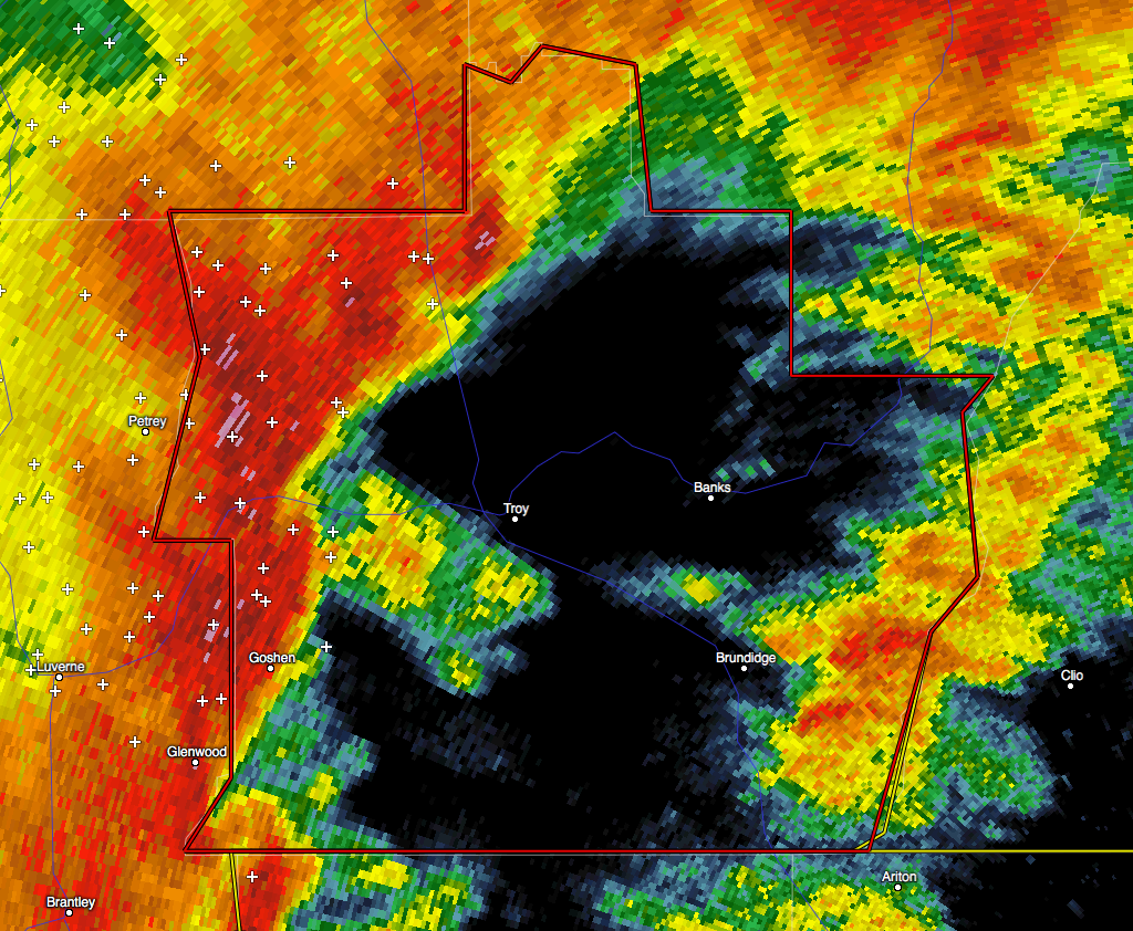
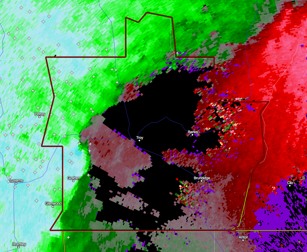
Tornado Warning Continues For Parts Of Pike County Until 945 AM CST FOR
Jan 21st @ 9:01 am
At 930 AM CST, a severe squall line capable of producing both
tornadoes and extensive straight line wind damage was located along a
line extending from near Boot Hill to near Ariton, moving east at 50
mph.
HAZARD…Tornado.
SOURCE…Radar indicated rotation.
IMPACT…Flying debris will be dangerous to those caught without
shelter. Mobile homes will be damaged or destroyed. Damage
to roofs, windows, and vehicles will occur. Tree damage is
likely.
Locations impacted include…
Tennille and Josie.
Tornado Warning Continues For Parts Of Pike County Until 945 AM CST FOR EASTERN
Jan 21st @ 9:01 am
At 921 AM CST, tornado producing storms were located along a line
extending from near Beans Crossroads to 7 miles south of Brundidge,
moving east at 60 mph.
HAZARD…Damaging tornado.
SOURCE…Radar confirmed tornado.
IMPACT…Flying debris will be dangerous to those caught without
shelter. Mobile homes will be damaged or destroyed. Damage
to roofs, windows, and vehicles will occur. Tree damage is
likely.
Locations impacted include…
Troy, Brundidge, Banks, Linwood, Antioch, Brundidge Municipal
Airport, Josie, Sandfield, Tennille, Tarentum, Monticello and
Hamilton Crossroads.
Tornado Warning Continues For Parts Of Pike County Until 945 AM CST FOR EASTERN
Jan 21st @ 9:01 am
At 919 AM CST, a severe squall line capable of producing both
tornadoes and extensive straight line wind damage was located along a
line extending from near Beans Crossroads to 7 miles south of
Brundidge, moving east at 60 mph.
HAZARD…Tornado.
SOURCE…Radar indicated rotation.
IMPACT…Flying debris will be dangerous to those caught without
shelter. Mobile homes will be damaged or destroyed. Damage
to roofs, windows, and vehicles will occur. Tree damage is
likely.
Locations impacted include…
Troy, Brundidge, Banks, Linwood, Antioch, Brundidge Municipal
Airport, Josie, Sandfield, Tennille, Tarentum, Monticello and
Hamilton Crossroads.
Tornado Warning Continues For Parts Of Pike County Until 945 AM CST FOR PIKE
Jan 21st @ 9:01 am
At 909 AM CST, a severe squall line capable of producing both
tornadoes and extensive straight line wind damage was located along a
line extending from near Linwood to 9 miles southeast of Goshen,
moving east at 55 mph.
HAZARD…Tornado.
SOURCE…Radar indicated rotation.
IMPACT…Flying debris will be dangerous to those caught without
shelter. Mobile homes will be damaged or destroyed. Damage
to roofs, windows, and vehicles will occur. Tree damage is
likely.
Locations impacted include…
Troy, Brundidge, Banks, Troy University, Linwood, Antioch, Troy
Municipal Airport, Brundidge Municipal Airport, Mossy Grove, Josie,
Tennille, China Grove, Tarentum, Monticello, Sandfield and Hamilton
Crossroads.
Tornado Warning Issued For Parts Of Pike County
Jan 21st @ 9:01 am
The National Weather Service in Birmingham has issued a
* Tornado Warning for…
Pike County in southeastern Alabama…
* Until 945 AM CST
* At 858 AM CST, severe thunderstorms capable of producing both
tornadoes and extensive straight line wind damage were located
along a line extending from 6 miles northeast of Ansley to near
Glenwood, moving east at 60 mph.
HAZARD…Tornado.
SOURCE…Radar indicated rotation.
IMPACT…Flying debris will be dangerous to those caught without
shelter. Mobile homes will be damaged or destroyed.
Damage to roofs, windows, and vehicles will occur. Tree
damage is likely.
* Locations impacted include…
Troy, Brundidge, Goshen, Banks, Ansley, Troy Municipal Airport,
Troy University, Linwood, Antioch, Brundidge Municipal Airport,
Mossy Grove, Josie, Tennille, China Grove, Henderson, Tarentum,
Monticello, Sandfield, Orion and Hamilton Crossroads.
Category: Current Warnings
About the Author (Author Profile)
Subscribe
If you enjoyed this article, subscribe to receive more just like it.


