Morning Weather Xtreme for 1/27: Tranquil Weather Pattern For Alabama
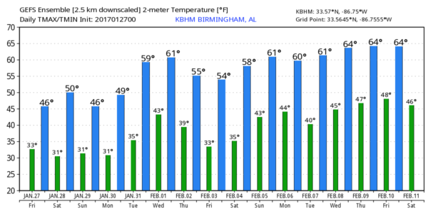
COLD MORNING: Birmingham dropped to 32 degrees at 6:00 this morning; first time we have been at the freezing mark since January 9. A number of communities to the north are in the upper 20s, and the sky is mostly fair. Today will be another cool, dry day with ample sunshine and a high in the 47-50 degree range this afternoon, about 5 degrees below average for late January.
THE ALABAMA WEEKEND: Tomorrow will be another mostly sunny, cool day. We start the day near 30 degrees, then rising into the low 50s by afternoon. We will see an increase in clouds Sunday, but it looks like the weather stays dry with only a small risk of a few sprinkles over the northeast corner of the state. Sunday’s high will be in the 47-51 degree range for most communities.
NEXT WEEK: The cool, dry pattern continues. Partly sunny days, mostly fair nights. Monday’s high will be in the 50s… then we creep into the low 60s Tuesday and Wednesday, before cooling back into the 50s Thursday and Friday. We could see a touch of light rain late in the week, but for now it doesn’t look like anything really significant.
The bottom line is that we see no real “high impact” events here for the next 10-15 days. No bitterly cold Arctic air, no winter storms, no severe thunderstorms, no flooding, no tornadoes. See the Weather Xtreme video for maps, graphics, and more details.
THREE YEARS AGO TODAY: A winter storm warning was issued for the southern half of Alabama for the following day, January 28, 2014, with a “winter weather advisory” up to places like Greensboro, Brent, Alabaster, and Sylacauga. Only a “dusting” was expected along I-20, including Tuscaloosa, Birmingham, Anniston. On the blog I wrote “Remember, we don’t have much experience in forecasting winter weather events in Alabama, so expect a few surprises along the way. Some will be delighted with the snow amounts they get, others severely disappointed.”
Most of you well know the “dusting” turned out to be 1-2″ along the I-20 corridor, which in the overall scheme of things is not much of a forecast error, but what we missed was the impact on roads. And we missed it badly. This turned into “snowmageddon”… more tomorrow.
As always, watch me for the full weather story on ABC 33/40 News this evening at 4, 5, 6, and 10:00!
WEATHER BRAINS: Don’t forget you can listen to our weekly 90 minute netcast anytime on the web, or on iTunes. This is the show all about weather featuring many familiar voices, including our meteorologists here at ABC 33/40.
CONNECT: You can find me on all of the major social networks…
Facebook
Twitter
Google Plus
Instagram
Pinterest
Snapchat: spannwx
I will be speaking to Jubilee Academy, a home school group, in Irondale this morning… look for the next Weather Xtreme video here by 4:00 this afternoon. Enjoy the day!
Category: Alabama's Weather
About the Author (Author Profile)
James Spann is one of the most recognized and trusted television meteorologists in the industry. He holds the AMS CCM designation and television seals from the AMS and NWA. He is a past winner of the Broadcast Meteorologist of the Year from both professional organizations.Subscribe
If you enjoyed this article, subscribe to receive more just like it.


