Some Rain At Times Today
RADAR CHECK: Rain is falling over parts of the Tennessee Valley of North Alabama early this morning; and more showers were pushing into the western counties of the state…
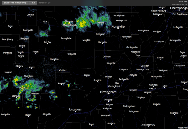
We will forecast a few periods of rain today thanks to a slow moving cold front drifting down into North Alabama. Rain amounts should be 1/4″ or less for most places, and I don’t expect any thunder. Otherwise, the day will be cloudy and cooler with a high in the mid 50s, back to where we should be for early February based on averages.
TOMORROW AND THE WEEKEND: The front should push down toward U.S. 80 early tomorrow morning, meaning the best chance of light rain should be over the southern half of the state. For the most part, North/Central Alabama looks dry and colder tomorrow with a high in the 48-51 degree range; the sky will stay mostly cloudy although the sun could break through during the afternoon hours.
Saturday will be a cool, dry day with a good supply of sunshine. We start the day below freezing, but rise into the mid 50s by afternoon. And, models continue to trend drier Sunday. The NAM model suggests some chance of light rain very early Sunday morning, perhaps in the pre-dawn hours, followed by mostly dry conditions during the daylight hours. The sky Sunday will feature more clouds than sun, and the high will be between 57 and 60 degrees. Any rain early Sunday looks light and spotty.
NEXT WEEK: A new storm will form west of Alabama, and for now it looks like the best chance of rain from that feature will come Tuesday and Tuesday night. A few thunderstorms could be involved, but with the best dynamic support well to the north, it doesn’t look like severe weather will be an issue; rain amounts should be in the 1/2 inch range. Colder air returns later in the week with a high Thursday between 45 and 50 degrees; a freeze is likely by Friday morning (February 10).
Still no sign of any really high impact (severe storms, snow, ice, extreme cold) events around here for the next 10-15 days. See the Weather Xtreme video for maps, graphics, and more details.
As always, watch me for the full weather story on ABC 33/40 News this evening at 4, 5, 6, and 10:00!
WEATHER BRAINS: Don’t forget you can listen to our weekly 90 minute netcast anytime on the web, or on iTunes. This is the show all about weather featuring many familiar voices, including our meteorologists here at ABC 33/40.
CONNECT: You can find me on all of the major social networks…
Facebook
Twitter
Google Plus
Instagram
Pinterest
Snapchat: spannwx
I have a weather program this morning at Aliceville Elementary School in Pickens County… look for the next Weather Xtreme video here by 4:00 this afternoon. Enjoy the day!
Category: Alabama's Weather
About the Author (Author Profile)
James Spann is one of the most recognized and trusted television meteorologists in the industry. He holds the AMS CCM designation and television seals from the AMS and NWA. He is a past winner of the Broadcast Meteorologist of the Year from both professional organizations.Subscribe
If you enjoyed this article, subscribe to receive more just like it.


