Much Cooler By The Weekend
WARM LATE WINTER DAY: Temperatures are in the 70s across most of Alabama this afternoon with a partly sunny sky. No rain on radar, and we stay warm and dry tomorrow. Some places will be flirting with 80 degrees tomorrow afternoon, and there is a good chance we will see a number of new record highs across the Deep South.
ACTION TO THE NORTH: A blizzard is getting underway this evening over parts of South Dakota, Iowa, Nebraska, and Minnesota, in the cold air sector of a strong surface low moving through the Great Plains. Severe storms are likely in the warm sector tomorrow south and east of the surface low; an “enhanced” severe weather risk has been defined for parts of Indiana, Michigan, Ohio, and Kentucky…
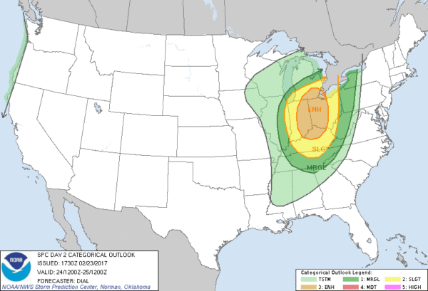
The “marginal” risk clips the northeast corner of Alabama tomorrow night; showers and storms will pass through our state with the trailing cold front then, but the best dynamic support for storms is far to the north, and moisture levels will be limited. Bottom line is that the overall threat for severe weather across North Alabama tomorrow night looks very low for now.
COOL CHANGE: Much cooler air blows into Alabama over the weekend, coming across the fresh snow pack up north. Saturday and Sunday will be sunny; the high Saturday will be in the upper 50s, followed by low 60s Sunday. A freeze is likely for most communities early Sunday morning with a low between 28 and 32 degrees.
NEXT WEEK: The first half of the week will be wet and unsettled. Rain and storms arrive Monday with the first short wave; the surface front will stall out around I-20, meaning showers are still possible Tuesday. Then, the next wave arrives Wednesday with another round of rain and storms. Strong storms will be possible Wednesday, but it remains to be seen if they will reach severe limits. Then, Thursday and Friday look dry and sharply cooler. Another freeze seems very possible by Friday morning March 3. See the Weather Xtreme video for maps, graphics, and more details.
Click here to see the Beach Forecast Center page. Save Up To 25% on Spring Break Beach Vacations on the Alabama Gulf Coast with Brett/Robinson! The Beach Forecast is partially underwritten by the support of Brett/Robinson Vacation Rentals in Gulf Shores and Orange Beach. Click here to see Brett/Robinson’s best beach offers now!.
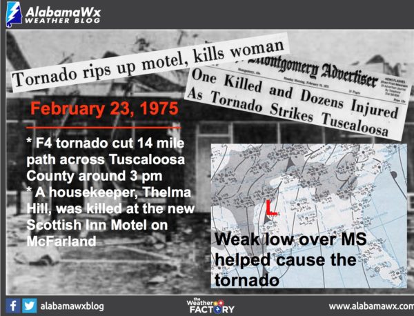
ON THIS DATE IN 1975: An EF-4 tornado moved through the southern and east parts of the city of Tuscaloosa… it first touched down in the Taylorville community and then skipped northeastward before hitting the Skyland Park area and moving on to the McFarland Blvd. exit area of I-59/20. It went on to affect parts of the Alberta City-Leland Park area and then on to Holt.
The official path length was 14.4 miles. Along it, 289 homes were destroyed or heavily damaged, along with 20 businesses and 21 mobile homes. The tornado nearly destroyed the new Scottish Inn motel on I-59 at McFarland. The fatality was a 23 year old housekeeper named Thelma Hill, killed when most of the second floor of the motel was sheared away by the tornado causing a wall to fall on her.
WEATHER BRAINS: Don’t forget you can listen to our weekly 90 minute netcast anytime on the web, or on iTunes. This is the show all about weather featuring many familiar voices, including our meteorologists here at ABC 33/40.
CONNECT: You can find me on all of the major social networks…
Facebook
Twitter
Google Plus
Instagram
Pinterest
Snapchat: spannwx
I enjoyed seeing the students from Knollwood Christian School in Sylacauga, and their home school co-op today… be looking for them on the Pepsi KIDCAM today at 5:00 on ABC 33/40 News! The next Weather Xtreme video will be posted here by 7:00 a.m. tomorrow…
Category: Alabama's Weather
About the Author (Author Profile)
James Spann is one of the most recognized and trusted television meteorologists in the industry. He holds the AMS CCM designation and television seals from the AMS and NWA. He is a past winner of the Broadcast Meteorologist of the Year from both professional organizations.Subscribe
If you enjoyed this article, subscribe to receive more just like it.


