

Line Of Thunderstorms Pushing Through Northern Parts Of Central Alabama At Midday
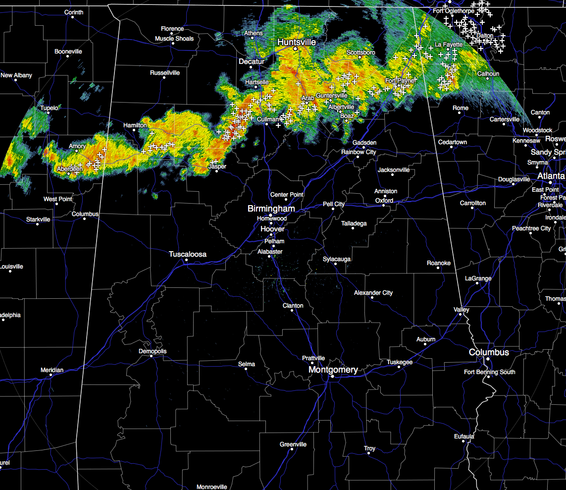

HOW’S THE WEATHER ACROSS CENTRAL ALABAMA AT MIDDAY
A line of showers and thunderstorms are moving east-northeastwardly across the northern parts of Central Alabama, mainly north of a warm front that is currently draped over the northwestern through the central parts of the area. A few heavy thunderstorms are occurring over Arley and Addison, and will soon affect Cullman, Good Hope, and Dodge City. Nothing is severe at this juncture, and should stay that way throughout the day. A few could get strong though, especially in the northwest corner of the area. These storms do have plenty of lightning, so please use common sense.
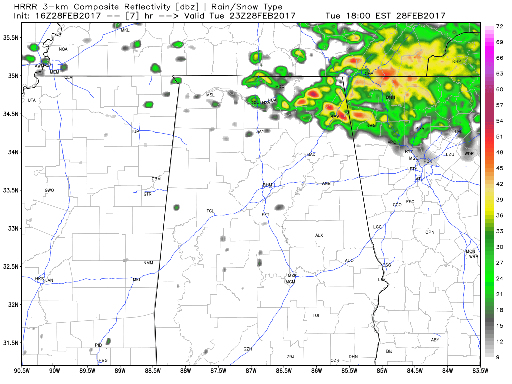
HRRR Simulated Radar at 5PM Today
For the remainder of the day today, the warm front will continue its progression across the area and will be draped across the northeastern parts of the area by tonight. Storms will continue to move across the northern portions of the area, but should be out of here by 5-7PM this evening. Skies will stay generally cloudy for the remainder of the day, and afternoon highs will be in the 70s to the lower 80s across the area from north to south. There could be a few scattered light showers across the northwestern parts of the area for tonight, but most of us will remain dry. Lows tonight will be in the lower to mid 60s.
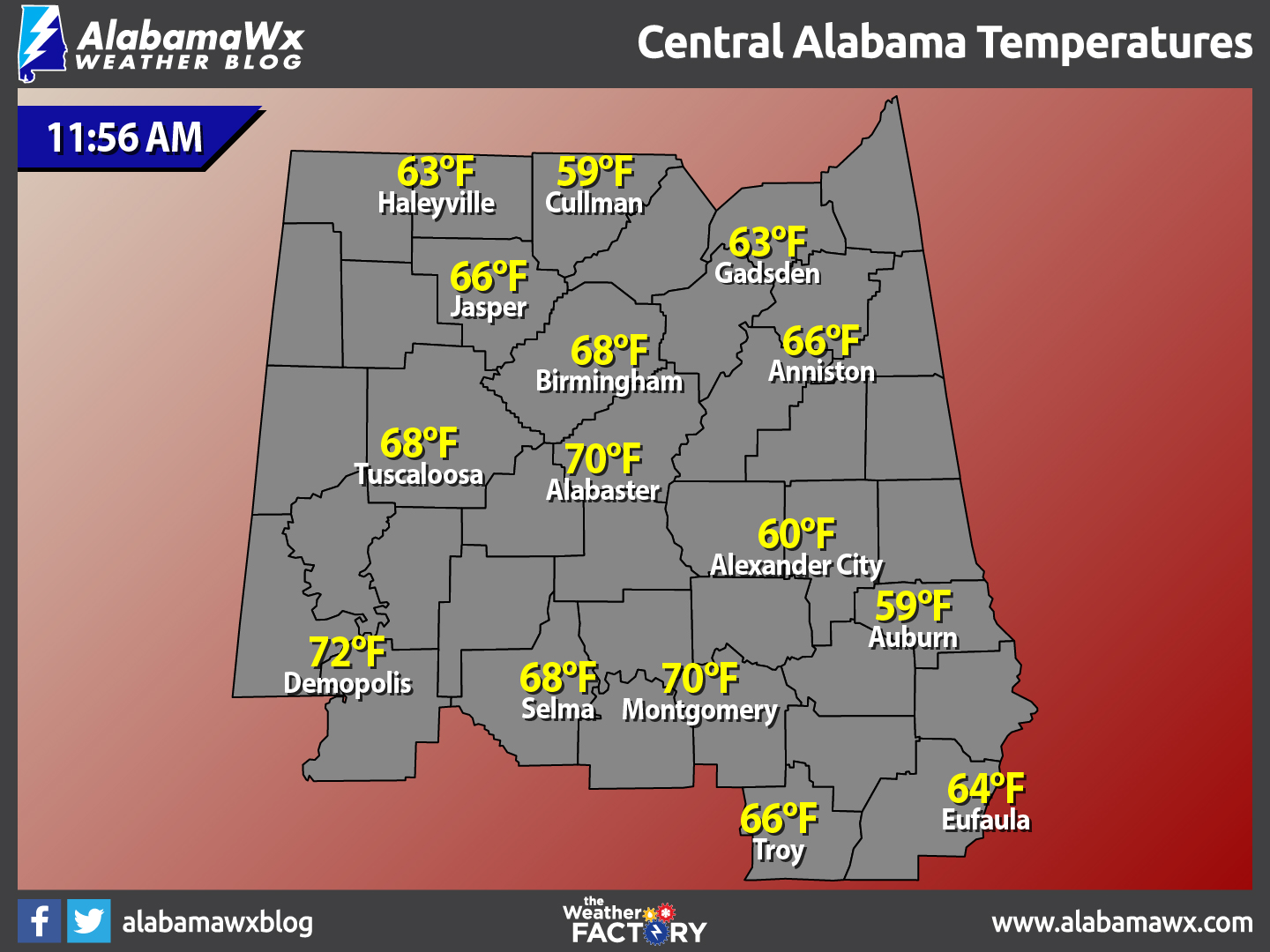
TEMPERATURES ACROSS CENTRAL ALABAMA
At 11:56 AM, temperatures are ranging from the upper 50s in the northern parts of Central Alabama, to the lower 70s to the south. The warm spot is currently Demopolis at 72ºF, with the cool spots are currently Auburn and Cullman at 59ºF.

ENHANCED RISK FOR SEVERE STORMS ON WEDNESDAY
The latest update to the Day 2 Severe Weather Outlook from the SPC continues to have much of the northern half of Central Alabama and the northern part of the state in an “Enhanced Risk” for severe storms, with the rest of the area in the “Slight Risk.” South of that, a “Marginal Risk” stretches from Greenville and Troy south to the Gulf Coast.
The latest run of the global models are in pretty close agreement with each other, and have the surface low located around the northwestern parts of Indiana to the southwestern parts of Michigan. It will strengthen as it moves off to the east-northeast through the day on Wednesday. With the low that far away from us, it will keep the best dynamic support well to the north.
We will have sufficient instability, along with helicity and shear values, to support severe thunderstorms. Dewpoints will be in the 62º to 67º range, and with temperatures forecasted to be in the mid 70s to the mid 80s across the area, the atmosphere will be ripe for development. Good news is that with the surface low being so far to the north, there is not a threat of large damaging tornadoes, but with the low level helicity values in the 100-175 m2s2 range, a few smaller tornadoes could be possible.
Our main threat will come from damaging straight-line winds associated with thunderstorms in a squall line that will move in with the cold front during the early afternoon through the evening hours. A few storms could develop out ahead of the front during the late morning to early afternoon that could take on a supercellular structure and start to rotate. If these do occur, they will happen in the northwestern parts of the state (Florence, Muscle Shoals, Russellville, Hamilton, and Double Springs), and this is where the isolated tornado threat would be the greatest as of now.

NAM-4k Simulated Radar at 4PM Wednesday
Timing will have the line of storms ahead of the front moving into far northwest Alabama around noon, then moving southeast during the afternoon and evening hours. For places like Birmingham, Tuscaloosa, Anniston, and Gadsden, the core threat will come between 2PM and 6PM.
Bottom line is to be prepared for severe weather. Have your trusty source of getting severe weather alerts charged and close by. Be ready to go into your safety plan if a warning polygon is issued for your location. Here is our on checking your severe weather plan.
WHAT TO EXPECT AT THE BEACH
For a detailed look at the weather from Fort Morgan over to Panama City Beach, click here to see a on our Beach Forecast Center page. Save Up To 25% on Spring Break Beach Vacations on the Alabama Gulf Coast with Brett/Robinson! The Beach Forecast is partially underwritten by the support of Brett/Robinson Vacation Rentals in Gulf Shores and Orange Beach. Click here to see Brett/Robinson’s best beach offers now!.
CLIMATOLOGY AND RECORDS FOR BIRMINGHAM
The normal high for February 28th is 62ºF, while the normal low is 39ºF. The record high for today was set back in 1981 at 80ºF. The record low was set back in 2002 at 17ºF.
TODAY IN WEATHER HISTORY
February 28, 2012: The first confirmed February tornado in Nebraska state history struck Lincoln and Logan Counties shortly after 4PM. The EF-0 tornado was on the ground intermittently for up to six minutes and traveled 3 miles before dissipating in southwest Logan County. The path of the tornado was over open rangeland and cropland where limited damage occurred. Patches of snow were still on the ground at the time.
WEATHERBRAINS
On last night’s show, the panel took on an important issue: should private weather forecasting firms be able to issue specialized warnings that enhance or in some cases conflict with official National Weather Service warnings. You can catch this week’s show on these outlets:
WeatherBrains website
Subscribe to the podcast on iTunes
THE BLOG IS ON SOCIAL MEDIA
@AlabamaWxBlog on Facebook
@AlabamaWxBlog on Twitter
WANT TO ADVERTISE ON THE ALABAMAWX WEATHER BLOG
Deliver your message to a highly engaged audience by advertising on the newly reformatted AlabamaWX.com website. The site enjoyed 10.2 MILLION page views in the past 12 months. Don’t miss out! We can customize a creative, flexible and affordable package that will suit your organization’s needs. Contact Bill Murray, at (205) 687-0782.
Category: Alabama's Weather
About the Author (Author Profile)
Scott Martin is an operational meteorologist, professional graphic artist, musician, husband, and father. Not only is Scott a member of the National Weather Association, but he is also the Central Alabama Chapter of the NWA president. Scott is also the co-founder of Racecast Weather, which provides forecasts for many racing series across the USA. He also supplies forecasts for the BassMaster Elite Series events including the BassMaster Classic.Subscribe
If you enjoyed this article, subscribe to receive more just like it.


