Severe Threat Has Ramped Up for Tonight; Talk about Cold and Snow Possibilities
Lots of water cooler chatter this morning about snow and severe weather.
Nice day in progress across Central Alabama with sunshine pushing readings to above 70F already at most locations heading for highs in the lower and middle 70s.
A buckling of the northern branch of the jet stream will push a colder airmass into Alabama on Friday. Showers and storms will impact the state starting tonight as a mesoscale convective system (fancy word for a big, organized cluster of storms) comes our way from the northwest. Those storms have formed over Kansas this morning and are poised to head southeast.
They will arrive in Northwest Alabama around 10-11 p.m., reaching Jasper and Cullman between 1-2 a.m. and Birmingham around 2:30.
The SPC has markedly upgraded the severe weather risk for tonight through the early morning hours.
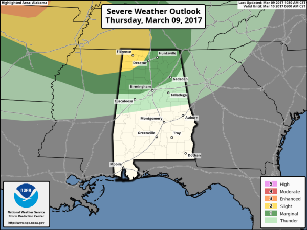
Damaging wind will be the primary threat with a small tornado risk for the Northwest Corner of the state around Muscle Shoals.
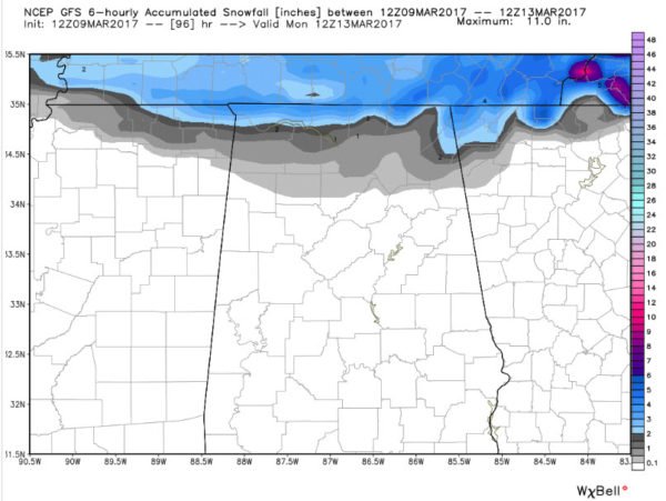
The new GFS model run is in. It still shows another system diving into Alabama Saturday night from the northwest. A cold rain will affect much of North and Central Alabama, possibly changing to snow late Saturday evening in places like the Quad Cities of Northwest Alabama (Muscle Shoals, Tuscumbia, Florence and Sheffield) with accumulating snows possible for the areas right along the Tennessee border.
Here is the GFS accumulated snow graphic for early Sunday morning:
Another weak system dives through Monday night and Tuesday bringing light snow chances to the Tennessee Valley. Accumulations would be light.
The final system of the week would arrive Thursday night and Friday as a low pressure center tracks right across Central Alabama from the Northwest. That system looks warm enough to be rain except at the highest elevations of Northeast Alabama.
In any case, it is going to turn colder. Here are the GFS temperatures for Birmingham for the next 10 days.
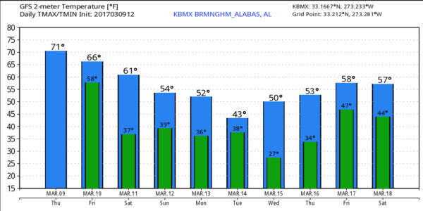
Looks like a widespread damaging freeze for the area next Wednesday morning.
Category: Alabama's Weather, ALL POSTS
About the Author (Author Profile)
Bill Murray is the President of The Weather Factory. He is the site's official weather historian and a weekend forecaster. He also anchors the site's severe weather coverage. Bill Murray is the proud holder of National Weather Association Digital Seal #0001 @wxhistorianSubscribe
If you enjoyed this article, subscribe to receive more just like it.


