(Expired)
…THE SEVERE THUNDERSTORM WARNING FOR NORTHEASTERN MARION COUNTY IS
CANCELLED…
The storm which prompted the warning has weakened below severe
limits, and no longer pose an immediate threat to life or property.
Therefore the warning has been cancelled.
A severe thunderstorm watch remains in effect until 400 AM CST for
northwestern Alabama.
Severe Thunderstorm Warning Continues For Parts Of Marion County Until 1:00AM
Mar 10th @ 12:08 am

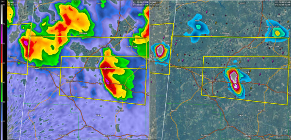
…A SEVERE THUNDERSTORM WARNING REMAINS IN EFFECT UNTIL 100 AM CST FOR NORTHERN MARION COUNTY… At 1221 AM CST, a severe thunderstorm was located 8 miles north of Weston, or 9 miles north of Hamilton, moving east at 45 mph.
HAZARD…60 mph wind gusts and half dollar size hail.
SOURCE…Radar indicated.
IMPACT…Hail damage to vehicles is expected. Expect wind damage to roofs, siding, and trees. Locations impacted include… Haleyville, Hackleburg, Bear Creek, Pigeye, Tessner and Upper Bear Creek Reservoir.
Severe Thunderstorm Warning Issued For Parts Of Marion County Until 1:00AM
Mar 10th @ 12:08 am
Intense thunderstorm north of Tremont MS will move east into Marion County AL affecting Shottsville, Pigeye and Hackleburg. It will also move toward Bear Creek and Haleyville.
Hail and damaging winds are possible.
This warning is in addition to the other severe thunderstorm that is in effect for Marion County.

The National Weather Service in Birmingham has issued a
* Severe Thunderstorm Warning for…
Northern Marion County in northwestern Alabama…
* Until 100 AM CST
* At 1207 AM CST, a severe thunderstorm was located near Tremont, or 11 miles south of Red Bay, moving east at 45 mph.
HAZARD…60 mph wind gusts and half dollar size hail.
SOURCE…Radar indicated.
IMPACT…Hail damage to vehicles is expected. Expect wind damage to roofs, siding, and trees.
* Locations impacted include…
Haleyville, Hackleburg, Bear Creek, Tessner, Pigeye, Shottsville and Upper Bear Creek Reservoir.
Category: ALL POSTS, Archived Warnings
About the Author (Author Profile)
Subscribe
If you enjoyed this article, subscribe to receive more just like it.


