

Severe Thunderstorm Warning Expired For Parts Of Marshall County
…THE SEVERE THUNDERSTORM WARNING FOR NORTHEASTERN MARSHALL COUNTY
WILL EXPIRE AT 315 PM CDT…
The storm which prompted the warning has weakened below severe
limits, and has exited the warned area. Therefore, the warning will
be allowed to expire.
A severe thunderstorm watch remains in effect until 900 PM CDT for
north central and northeastern Alabama.
Severe Thunderstorm Warning Continues For Parts Of Marshall County Until 3:15PM
Mar 27th @ 2:31 pm


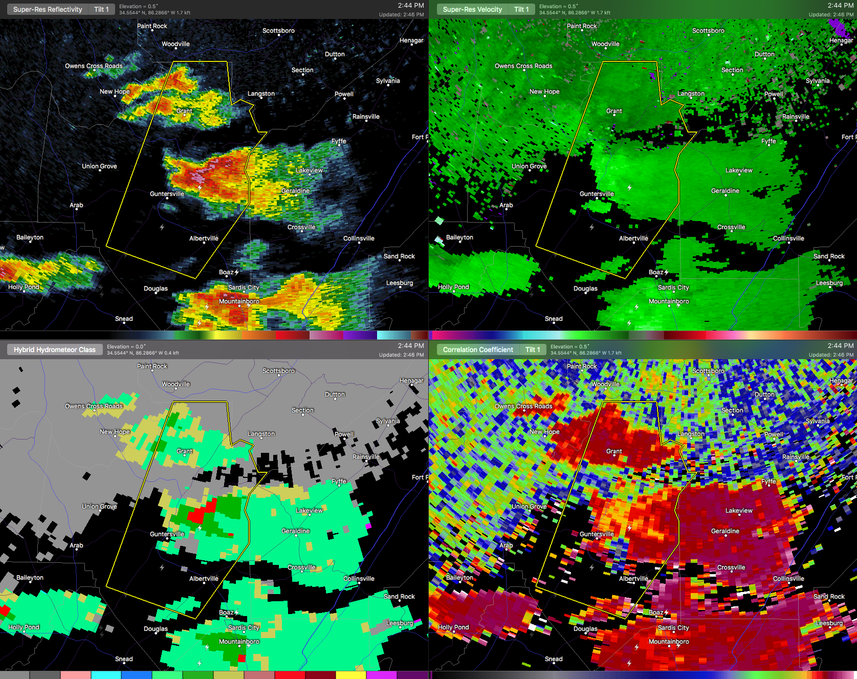
…A SEVERE THUNDERSTORM WARNING REMAINS IN EFFECT UNTIL 315 PM CDT FOR NORTHEASTERN MARSHALL COUNTY… At 245 PM CDT, a severe thunderstorm was located near Guntersville, moving northeast at 35 mph.
HAZARD…Golf ball size hail and 60 mph wind gusts.
SOURCE…Public. Golf ball sized hail was reported in Guntersville.
IMPACT…People and animals outdoors will be injured. Expect hail damage to roofs, siding, windows, and vehicles. Expect wind damage to roofs, siding, and trees. Locations impacted include… Albertville, Guntersville, Grant, Hustleville, Columbus City and Lake Guntersville St Park.
Severe Thunderstorm Warning Issued For Parts Of Marshall County Until 3:15PM
Mar 27th @ 2:31 pm

The National Weather Service in Huntsville Alabama has issued a
* Severe Thunderstorm Warning for…
Eastern Marshall County in northeastern Alabama…
* Until 315 PM CDT
* At 230 PM CDT, a severe thunderstorm was located near Guntersville, moving northeast at 35 mph.
HAZARD…60 mph wind gusts and quarter size hail.
SOURCE…Radar indicated.
IMPACT…Hail damage to vehicles is expected. Expect wind damage to roofs, siding, and trees.
* Locations impacted include…
Albertville, Guntersville, Grant, High Point, Columbus City, Lake
Guntersville St Park, Hustleville, Rabbit Town, Mountain View and
Hyatt.
Category: ALL POSTS, Archived Warnings
About the Author (Author Profile)
Subscribe
If you enjoyed this article, subscribe to receive more just like it.


