The Morning of April 3, 1974 Told Through the Eyes of J.B. Elliott
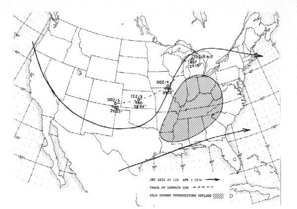
Graphic showing the Severe Weather Outlook issued on the morning of April 3, 1974 by the Severe Local Storms Forecast Center.
By Bill Murray
The midpoint of his overnight shift at the National Weather Service Forecast Office on West Oxmoor Road in Birmingham had just passed when Met Tech J.B. Elliott left his desk and walked into the teletype room. It was Elliott’s week to do dreaded midnight shifts. He had come on duty at twelve o’clock and would be there until 8 a.m.
Shifts were, and still are, an unavoidable part of working for the National Weather Service. After nearly two decades, he was used to it. He would mark his seventeenth anniversary with the Weather Service in just five days. He had worked at the Birmingham office for his entire career, a rarity in the NWS. Most weather people moved around frequently, especially early in their careers.
When he had started, it had been called the U.S. Weather Bureau and the Birmingham office had been in the terminal building at the Airport. The stately old building looked like it would be more in place on the grounds of a southern Country Club than an airport, with graceful columns adorning the front of the building. There were even rocking chairs on the front porch.
His first day on the job had started off with a bang, and today was going to be active like that day in 1957. J.B. had no formal training in weather, no degree in meteorology. But he had loved since his youngest days growing up in Hale County, in Alabama’s Black Belt south of Tuscaloosa. In fact, he had been born less than a month after the worst tornado outbreak in Alabama history had killed over 300 people. The first tornado of that dreadful day had touched down twenty five miles south of his hometown of Havana Junction. His mom always said that his fascination with the weather stemmed from the fact that heard thunder in the womb on that day, March 21, 1932.
J.B. loved listening to the old timers talk about the weather as they played checkers in the town square at Havana Junction. His father was killed in an industrial accident when he was just nine, and it was just his mom and sister after that. This meant getting up early to milk the cows and other chores.
His mother took a job in Tuscaloosa. One day she brought him a special present. A dime store thermometer. He meticulously recorded weather observations each day. He even got up an hour early so that he could tune into radio stations across the country to jot down their weather reports. He would carefully record these on a map of the United States, producing his own personal weather forecasts.
After graduating from Hale County High School in Akron, J.B. moved to Bessemer, near Birmingham, after getting a job with a wholesale grocery company. But he stayed close to the weather by volunteering as a U.S. Weather Bureau Cooperative Observer. In this role, he supplied daily weather reports of temperature and precipitation.
He frequently made the fifteen mile trip to the Birmingham Airport on Saturdays to hang out with the meteorologists there. He applied for a job as a Meteorological Technician, but there was a rule that if there were any veterans on the Federal Register looking for a job, they had priority over a civilian, a policy that J.B. patriotically supported.
Mr. Charles Bradley, the Chief of the Birmingham Weather Bureau Office kept an eye out for an opportunity to get the young man on his staff. He recognized J.B.’s keen interest in the weather, realizing that what he lacked in formal training, he made up for in enthusiasm and dedication.
Then in late March 1957, Mr. Bradley called J.B.’s mother. He had an opening available that J.B. could fill. There was only one problem. J.B. was driving out west with a cousin to visit National Parks. They were making one last stop in Denver before heading into New Mexico, where they would be out of contact for the next two weeks. The once in a lifetime chance at the job of his dreams would evaporate.
Mrs. Elliott called their relatives. The men had not left yet. J.B. was able to see a government-approved doctor for his physical and the job was his. On his way home, newspaper headlines were dominated by a week of active weather, including a major tornado that had hit the city of Dallas on April 2nd.
After returning to Alabama, he reported for work on April 8, 1957 to fill out paperwork on his first day on the job. But there was no time for that. As soon as he walked in the door at the Weather Office that morning, he was pressed into service. Tornadoes were skipping across North Alabama and one was on the ground in the Red Mills community. Two people would be killed in Morgan County. At least four significant tornado struck North Alabama that day, including two tornadoes that modern research would estimate caused F3 damage. Of course, the F-Scale, which estimates tornado wind speeds from damage indicators was less than a year old in 1974, and it was actually the FPP scale, named for its founders, Theodore Fujita and Allen Pearson.
So, J.B. almost didn’t get paid for his first day answering the phones and helping the other weathermen that day. But he didn’t mind. He had been pitching in during his visits to the office for awhile. He didn’t tell his new boss Mr. Bradley, but he probably would have done the job for me. But now he had a career in weather.
Nearly seventeen years later, J.B. was on the precipice of the career-defining day in that weather career that would last until 1989. He stepped into the cacophony of the teletype room at the NWS office in the modern suburban office building on West Oxmoor Road around 4:15 a.m. that April 3rd. The building technically was in Homewood, a fact not lost on a certain caller to the office that threatened to have J.B.’s job if he didn’t stop answering the phone with the scripted response “National Weather Service Birmingham”.
J.B. and the other staff on duty early that morning had been waiting on the severe weather outlook from SELS. SELS was the Severe Local Storms Unit at the National Severe Storms Forecast Center in Kansas City. Surprisingly, SELS had only been in existence for twenty five years, not much longer than J.B. had been in the Weather Service.
The teletype room at West Oxmoor Road wasn’t much different than the teletype room that was in the weather office at the old Birmingham Airport terminal on J.B.’s first day. It was a small room, three of its walls lined with hulking, black metal teletype terminals that constantly clacked out from all over the country on rolls of yellow paper.
Two of them, the Service A and Service C teletypes, spit out row after row of SAs, or surface aviation observations. The coded reports told meteorologists a story about the weather at hundreds of airport weather stations around the country, including the cloud heights, visibilities, current weather, temperatures, dewpoints, wind direction and speed, barometric pressure and precipitation. They were Greek to the layman, but to a meteorologist, they were chock full of important information.
One machine tied the office directly to SELS, network radar sites and other NWS offices. The RAWARC (Radar Report and Warning Coordination) line was a 100 word per minute circuit that transmitted critical watch and warning data as well as coded radar reports from the powerful network radar stations. Forecasters at SELS sent weather watches and other information over this circuit to the local weather offices.
Watches were issued for a wide geographic area, generally several thousand square miles at a time, usually for four to six hours. Watches delineated the area that SELS forecasters believed would be affected by tornadoes or severe thunderstorms. They had already issued a tornado watch the evening before. At 4 a.m. on April 3rd, they were busy issuing two watches for parts of states from Texas to Kentucky. This really was going to be a potent weather system.
The issuance of the watches delayed their daily severe weather forecast for the country, the Severe Weather Outlook. This product was anxiously awaited by forecasters around the National Weather Service and it was displayed each morning on the Today Show. J.B. typed a quick message into the Request/Reply machine. This teletype circuit was connected to a computer in Kansas City which generated a reply with the requested product. Forecasters used it to ask for products like watched to be retransmitted. The Severe Weather Outlook had still not been issued.
The Public Forecaster had already sent the State Weather Forecast for Alabama. He had composed the forecast and had given it to J.B. to be composed on the teletype. Hunt and peck, but on steroids, was J.B.’s typing technique and the rapid fire method worked amazingly well. There was no backspace on a teletype machine. As you typed, it punched a thin ½ ribbon of paper tape. The nine pins actually punched little holes in the tape that another teletype machine could read. This allowed messages from one machine to be resent on another machine without retyping them. It was a critical component in the communications process that would be considered antiquated in the computer age.
But still, it took time to compose a message, and the state forecast product was due out by 4:45 a.m. J.B. went back to his desk to compose the message for the forecaster on duty. The forecast didn’t include any mention of severe thunderstorms. He had already composed the message when one of the forecasters walked in with a copy of the Severe Weather Outlook, hot off the wire from Kansas City.
ZCZC
ACU6 KMKC
ALSYM A KKCC
ZCZC
MKC AC 030900
VALID 031200Z-041200Z
SEE WW NRS 90 AND 91…
SCTD SVR TSTMS EXPCTD TODAY AND TONIGHT FM NE TEX ACRS ARK SE MO ILL IND OHIO W VA KY TENN WRN VA WRN NC EXTRM NW S C NRN AND CNTRL ALA NRN AND CENTRL MISS WRN HALF LA AND NW GA.
STG LOW PRESSR AREA EXPCTD INTO NE MO BY 00Z WITH CLD FNT SWD THRI ERN ARK AND LA. STG SLY WNDS WITH COOLING ALF EXPCTD TO GIVE SVR TSTMS… WITH ACTVTY SPRDG EWD DURG PD.
GEN TSTMS TO RT OF LN VCT FTW OKC TOP GRI MSP SAW..CONT… MSS UWM …CONT… SSI CTY.
Translated, the message said this:
SCATTERED SEVERE THUNDERSTORMS EPECTED TODAY AND TONIGHT FROM NORTHEAST TEXAS ACROSS ARKANSAS, SOUTHEAST MISSOURI, ILLINOIS, INDIANA, OHIO, WEST VIRGINIA, KENTUCKY, TENNESSEE, WESTERN VIRGINIA, WESTERN NORTH CAROLINA, EXTREME NORTHWEST SOUTH CAROLINA, NORTHERN AND CENTRAL ALABAMA, NORTHERN AND CENTRAL MISSISSIPPI, NORTHERN HALF LOUISIANA AND NORTHWEST GEORGIA.
STRONG LOW PRESSURE AREA EXPECTED INTO NORTHEAST MISSOURI BY 0000Z WITH COLD FRONT SOUTHWARD THROUGH EASTERN ARKANSAS AND LOUISIANA. STRONG SOUTHERLY WINDS WITH COOLING ALOFT EXPECTED TO GIVE SEVERE THUNDERSTORMS…WITH ACTIVITY SPREADING EASTWARD DURING THE PERIOD.
It was one of the biggest, if not the biggest, convective outlook they had ever seen. This confirmed what the forecasters at the National Weather Service in Birmingham already thought. It was going to be a really bad day.
First, there was work to be done. J.B. set down at his tape punch and hammered out the zone forecasts. The forecasts for the northern and western sections of Alabama mentioned the possibility of locally severe thunderstorms by evening.
Then J.B. started working on his favorite product, the Alabama Weather Summary, a narrative that allowed him a little creative license. He had even been selected to attend a special writing training course in Kansas City. He penned the following message:
ALABAMA READY FOR ANOTHER BOUT WITH THUNDERSTORMS…
THUNDERSTORMS WILL OVERSPREAD ALABAMA FROM THE WEST THIS AFTERNOON AND TONIGHT AND SOME OF THEM COULD BECOME SEVERE. THE SITUATION WILL BE WATCHED CLOSELY TODAY AS THUNDERSTORMS ENTER NORTHWEST ALABAMA THIS AFTERNOON AND SPREAD EAST AND SOUTHEAST OVER THE STATE THIS AFTERNOON AND TONIGHT. THEY WILL BE LOCALLY HEAVY OVER MOST OF THE STATE WITH THE HEAVIEST ONES LIKELY OVER THE NORTH AND CENTRAL COUNTIES.
THE LATEST DEVELOPMENTS ARE BLAMED ON THE STRONGEST STORM SYSTEM OF THE SPRING SO FAR. THE DEEP LOW IS CENTERED OVER KANSAS THIS MORNING MOVING NORTHEAST.
J.B. also served as the unofficial weather historian for the state of Alabama, with an uncanny ability to recall dates on significant events. He frequently wrote special statements that recalled historic events, and that morning was no different. He transmitted a special release stating that April 3rd was the anniversary of killer tornadoes, which hit Saugatuck, Michigan and Wichita Falls, Texas in 1964.
A couple of hours later, J.B. took the elevator from the fourth floor and headed into the parking lot. He made the twenty minute drive to his home in the Huffman neighborhood of northeastern Birmingham. He stopped at the Food World grocery store near his house and went in for a few items. The cashier made small talk about the weather. “They say it’s going to get bad today,” she said. J.B. agreed, not elaborating, ready to get home to grab a few winks since he would most likely get called in early before his shift that started at midnight again. “Have a great day, “ she called as he headed back out into the unseasonable heat and humidity. “Lady, you’re too late,” he thought to himself.
By the morning of April 4th, the tornado count would be in the hundreds and the death toll would as well. The 147 tornadoes that occurred in twenty-hour hours was a record. A total of 310 Americans would be killed that fateful afternoon and evening. The record was one that many never thought would be broken. For many it was in the unbreakable category with records like Cal Ripken’s 2,632 games played streak.
But on the afternoon of April 27, 2011, an amazing 198 tornadoes occurred and 313 people died across the nation. Two hundred and fifty two died in Alabama. The events were similar in some ways. In fact, by 4 p.m., J.B. would realize that the event was looking a lot like 1974 all over again as he did continuous severe weather coverage on several Birmingham radio stations, providing a reassuring voice in the storm.
By the next morning, he would know that the event was way worse than the Superoutbreak, and like the unthinkable March 21, 1932 outbreak that claimed over three hundred lives in Alabama alone as ten violent tornadoes ripped across the state in two waves.
We’ve definitely come a long way in the warning process, built on the shoulders of men like J.B. Elliott. But April 27th and May 22nd in Joplin reminded us that we’re not there yet.
Category: ALL POSTS, Met 101/Weather History
About the Author (Author Profile)
Bill Murray is the President of The Weather Factory. He is the site's official weather historian and a weekend forecaster. He also anchors the site's severe weather coverage. Bill Murray is the proud holder of National Weather Association Digital Seal #0001 @wxhistorianSubscribe
If you enjoyed this article, subscribe to receive more just like it.


Comments (35)
Trackback URL | Comments RSS Feed
Sites That Link to this Post