Strong, But Not Severe Storms Moving Through Tuscaloosa, Toward Birmingham
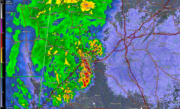
Strong thunderstorms have moved into West Alabama’s Tuscaloosa and Hale Counties early this morning.
Lots of lightning and loud thunder, but they are elevated in nature, not surface based, so severe weather is not likely.
It appears that the enhanced storms are associated with a small area of low pressure or an upper level disturbance.
This is evidenced by the fact that the dewpoint at Meridian rose to 70F before falling back to 63F behind the feature.
Another surface wave or upper disturbance is over western Mississippi. Storms southwest of Jackson are severe and warnings are in effect.
A very tropical airmass covers Southern Louisiana and Mississippi into coastal Alabama and Northwest Florida early this morning. It is south of a warm front that snakes across southern Mississippi and West Central Alabama. Our main surface low is near Texarkana.
The severe storms over Central Mississippi will push northeastward overnight and will impact Central and South Alabama during the morning hours later today.
Category: Alabama's Weather, ALL POSTS
About the Author (Author Profile)
Bill Murray is the President of The Weather Factory. He is the site's official weather historian and a weekend forecaster. He also anchors the site's severe weather coverage. Bill Murray is the proud holder of National Weather Association Digital Seal #0001 @wxhistorianSubscribe
If you enjoyed this article, subscribe to receive more just like it.


