

Severe Thunderstorm Warning Continues For Parts Of Pike County Until 9:45AM


…A SEVERE THUNDERSTORM WARNING REMAINS IN EFFECT UNTIL 945 AM CDT FOR PIKE COUNTY… At 933 AM CDT, severe thunderstorms were located along a line extending from near Beans Crossroads to near Brundidge, moving east at 40 mph.
HAZARD…70 mph wind gusts.
SOURCE…Radar indicated.
IMPACT…Expect considerable tree damage. Damage is likely to mobile homes, roofs, and outbuildings. Locations impacted include… Troy, Brundidge, Banks, Antioch, Linwood, Troy University, Tennille, Monticello, Hamilton Crossroads, Josie, China Grove, Sandfield, Tarentum, Brundidge Municipal Airport and Mossy Grove.
Severe Thunderstorm Warning Canceled For Parts Of Montgomery County
Apr 3rd @ 8:58 am
…THE SEVERE THUNDERSTORM WARNING FOR SOUTHEASTERN MONTGOMERY COUNTY IS CANCELLED… The storms which prompted the warning have moved out of the warned area. Therefore, the warning has been cancelled. A severe thunderstorm watch remains in effect until 1100 AM CDT for south central and southeastern Alabama.
Severe Thunderstorm Warning Continues For Parts Of Montgomery And Pike Counties Until 9:45AM
Apr 3rd @ 8:58 am


…A SEVERE THUNDERSTORM WARNING REMAINS IN EFFECT UNTIL 945 AM CDT FOR PIKE AND SOUTHEASTERN MONTGOMERY COUNTIES… At 920 AM CDT, severe thunderstorms were located along a line extending from Pine Level to near Troy Municipal Airport to 9 miles southeast of Goshen, moving northeast at 45 mph.
HAZARD…70 mph wind gusts.
SOURCE…Radar indicated.
IMPACT…Expect considerable tree damage. Damage is likely to mobile homes, roofs, and outbuildings. Locations impacted include… Troy, Brundidge, Goshen, Banks, Pine Level, Antioch, Linwood, Ansley, Troy Municipal Airport, Troy University, Tennille, Monticello, Hamilton Crossroads, Orion, Josie, China Grove, Sandfield, Tarentum, Brundidge Municipal Airport and Currys.
Severe Thunderstorm Warning Issued For Parts Of Montgomery And Pike Counties Until 9:45AM
Apr 3rd @ 8:58 am
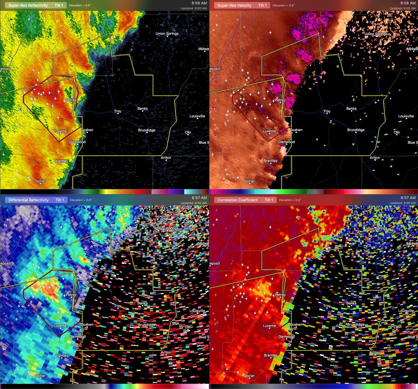

The National Weather Service in Birmingham has issued a
* Severe Thunderstorm Warning for…
Pike County in southeastern Alabama…
Southeastern Montgomery County in south central Alabama…
* Until 945 AM CDT
* At 858 AM CDT, severe thunderstorms were located along a line extending from near Lapine to near Petrey to Glenwood, moving northeast at 45 mph.
HAZARD…70 mph wind gusts and penny size hail.
SOURCE…Radar indicated.
IMPACT…Expect considerable tree damage. Damage is likely to mobile homes, roofs, and outbuildings.
* Locations impacted include…
Troy, Brundidge, Goshen, Meadville, Banks, Pine Level, Dublin, Linwood, Grady, Ramer, Strata, Naftel, Antioch, Ansley, Troy
Municipal Airport, Troy University, Tennille, Josie, Currys and
Monticello.
Category: ALL POSTS, Archived Warnings
About the Author (Author Profile)
Subscribe
If you enjoyed this article, subscribe to receive more just like it.


