

Filling in the Blanks
Matt Grantham, one of the brilliant young forecasters at the National Weather Service in Birmingham has been on top of this event since the weekend. He penned an outstanding and foreboding forecast discussion a few minutes ago. He does a great job describing how the event should unfold today.
The important thing to note is that as the activity over South Alabama lifts northeast, it could produce a tornado or two as we said earlier.
It also may leave a boundary over East Alabama. If you want an example of where a boundary affected a situation, go back to April 8, 1998, when a temperature boundary caused by differential heating from cloudy/clear areas helped to spin up the Oak Grove Tornado.
Matt has filled in the blanks for some of the pieces of uncertainty in this situation. Let’s all be ready!
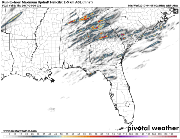
Here is a look at the accumulated updraft helicity maxima across the Southeast through this evening. Now this isn’t exactly where possible tornado tracks might be, but it does give an idea of what we might be up against with severe weather erupting here in Alabama late this afternoon and plowing into Georgia. We want our friends in West Georgia (and we have quite a few reading the blog) to be ready too.
Here’s Matt’s discussion:
A warm front is accelerating northward in far South Alabama this
morning, which has caused elevated supercell development. This
activity will spread northward through the pre-dawn hours. Hi-res
model guidance does not have a good handle on the current
convective situation, so it is difficult to know how this will
evolve through the rest of the morning. Complicating matters is
the presence of a subtle upper-level subtropical disturbance which
seems likely to cause early day warm sector contamination and the
development of a low-level jet impulse. The overall consensus is
for additional development through the late morning generally
along and east of a line from Demopolis to Gadsden and especially
across our southeast counties. The primary threat will probably be
large hail through 8 AM, though a tornado or two cannot be ruled
out. The warm sector should be established across most of the area
shortly after 8 AM when additional thunderstorm development is
likely in the areas previously mentioned. This is also when the
tornado threat will increase as a 40kt southwesterly low-level jet
becomes established, leading to 0-1 km SRH of 150-200 m2/s2. This
is normally not high enough for tornadoes in Alabama, but MLCAPE
values approaching 3000 J/kg should help offset the lackluster
low-level directional shear. This batch of storms will probably
exit into Georgia around Noon or 1 PM, leaving being somewhat
cooler air across East AL and West GA which may play a crucial
role in tornado potential later in the afternoon.
Another round of severe storms should initiate around 3-4 PM
along the cold front from Northwest AL southward to around
Demopolis. These storms should become severe with large hail as a
powerful 500 mb jet streak closes in on the area with 65-80 kt
flow across the warm sector. Initially the tornado threat with
these storms may be tempered by less than ideal low-level
directional shear, but this could change especially east of
Interstate 65. If the morning thunderstorm activity leaves behind
a substantial temperature gradient, significant backing of low-
level flow would be present, causing hodographs to become
enlarged. This type of mesoscale enhancement is difficult to
predict, but if it occurs, the threat for destructive, long-track
tornadoes will increase substantially as storms approach the AL/GA
state line around 6-8 PM.
Category: Alabama's Weather, ALL POSTS
About the Author (Author Profile)
Bill Murray is the President of The Weather Factory. He is the site's official weather historian and a weekend forecaster. He also anchors the site's severe weather coverage. Bill Murray is the proud holder of National Weather Association Digital Seal #0001 @wxhistorianSubscribe
If you enjoyed this article, subscribe to receive more just like it.


