Potentially Dangerous Severe Weather Set-Up Today
**No Weather Xtreme video due to ongoing weather issues**
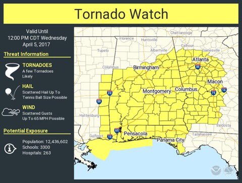
THIS MORNING: A tornado watch is in effect for much of Central and South Alabama until 12:00 noon.
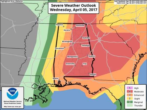
Weather parameters continue to come together for the potential for a significant severe thunderstorm/tornado event across the state later today, and SPC maintains a “moderate” risk (4 out of 5) for much of Central and East Alabama, with an “enhanced” risk (3 out of 5) for the western counties. There isn’t much change in the outlook from yesterday.
This is a rather complex setup today with multiple waves of storms likely. The air over the state becomes very unstable, with surface based CAPE values in excess of 3,000 j/kg in places, with a dynamic upper trough approaching with strong wind fields.
THREATS/PLACEMENT: All modes of severe weather are possible today, including large hail, damaging straight line winds, and hail. A few strong/violent, long track tornadoes are possible this afternoon, mainly over the eastern half of the state in the “moderate” risk. Please understand that doesn’t mean that there isn’t a chance of severe storms over the western counties. In fact, all 67 Alabama counties will have some threat of severe storms today.
TIMING: Storms are possible anytime from now through the evening hours. The severe weather threat should end in Tuscaloosa by 2:00 p.m… it should end in Birmingham by 5:00 p.m… and in Anniston/Gadsden by 7:00 p.m. as the storms move into Georgia.
IMPORTANT NOTES…
*The storms today will not be linear, but random, discrete, and cellular. This means there will be some places that won’t even see any rain. Other places will see strong to severe storms; some dangerous.
*With this type of setup, it is impossible to give specific start/stop times, and placement of storms for any one given community. You will simply need to be vigilant through the day and pay attention to warnings.
*Many ask about “is it safe to drive” from one place to another today. I really can’t answer that question since different people have a different tolerance level for driving in rain and storms. If you do drive, be sure you have a good warning app on your phone, and if a tornado warning is issued and you are in the polygon, pull off ASAP and get into some kind of building. A car is a death trap during a tornado.
*Will today be like April 27, 2011? The answer, of course, is no, April 27, 2011 was a generational tornado event that tends to happen once every 40 years or so. But I don’t like the question; if there is only one tornado in the state that happens to come down your street, then that is your “April 27”.
*As I wrote multiple times yesterday, this is April in Alabama, and severe weather threats are routine and to be expected. I think part of the problem is that we are coming off a relatively “quiet” five years; we simply aren’t used to an active season. No need to be overly anxious or worried today; just have a way of hearing warnings, have a good plan of action, and we will get through today just fine.
*There is always “bust potential” with every event like this; meaning a day when severe storms are not as widespread or intense as expected. When it comes to severe local convective storms, we still have much to learn. But we have to prepare for a potentially dangerous day.
CALL TO ACTION: Be sure you have a way of getting warnings; a NOAA Weather Radio is the baseline, and a good smart phone app is the other tier. Identify the safe place in your home, and be sure everyone knows where it is. And, in that safe place have helmets for everyone, along with hard sole shoes and preferably a portable airhorn in case you need help.
Be sure you have the ABC 33/40 app on your phone so you can watch our live severe weather coverage, if needed:
LATE SEASON COLD SNAP AHEAD: The storms exit Alabama this evening, and we turn much cooler tonight and tomorrow. Clouds linger tomorrow morning, and some patchy light rain is possible over the northern third of the state. Then, expect gradual clearing during he afternoon with temperatures not getting out of the 50s in many places. Then, we drop into the 38-41 degree range early Friday.
Friday will be a sunny, cool day with a high in the low 60s.
FROST POTENTIAL: With a clear sky and light wind, we project a low between 34 and 38 degrees early Saturday with high potential for frost; colder spots have very good chance of seeing a late season freeze. Growers beware.
THE WEEKEND: Look for a delightful weekend, with sunshine in full force Saturday and Sunday with a warming trend. We reach the upper 60s Saturday, and upper 70s Sunday.
Next chance of rain/storms should be around the middle of next week, Tuesday night or Wednesday.
STORM SPOTTER TRAINING AT THE BJCC SATURDAY: Our biggest storm spotter training event of the season will be Saturday at the BJCC from 9:00 until 2:00… we will have both the basic and the advanced class. I will be speaking as well; I hope to see many of you there.

Click here to see the Beach Forecast Center page. Save Up To 25% on Spring Break Beach Vacations on the Alabama Gulf Coast with Brett/Robinson! The Beach Forecast is partially underwritten by the support of Brett/Robinson Vacation Rentals in Gulf Shores and Orange Beach. Click here to see Brett/Robinson’s best beach offers now!.
CONNECT: You can find me on all of the major social networks…
Facebook
Twitter
Google Plus
Instagram
Pinterest
Snapchat: spannwx
Check the blog often today for updates!
Category: Alabama's Weather, ALL POSTS
About the Author (Author Profile)
James Spann is one of the most recognized and trusted television meteorologists in the industry. He holds the AMS CCM designation and television seals from the AMS and NWA. He is a past winner of the Broadcast Meteorologist of the Year from both professional organizations.Subscribe
If you enjoyed this article, subscribe to receive more just like it.


