Summer-like Easter Sunday for Central Alabama
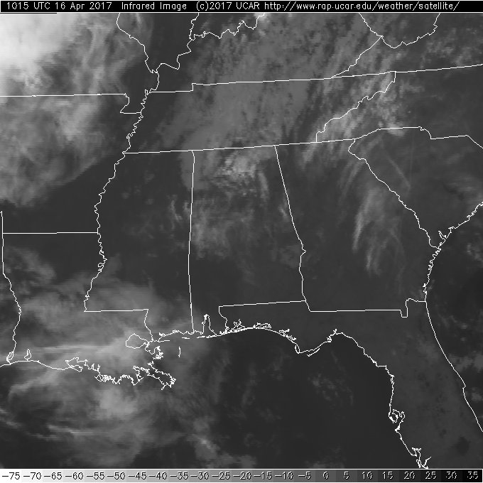
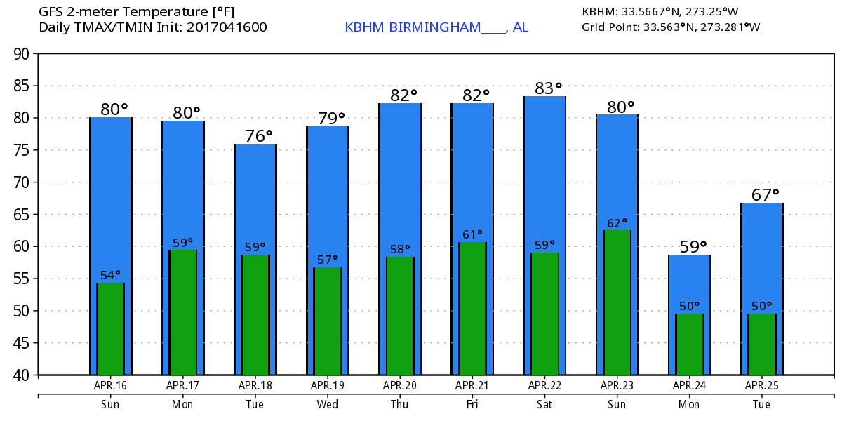
The morning satellite image this Easter Sunday morning looks a lot like the one we saw yesterday morning at this time with mid and high clouds floating through the Alabama sky. The surface high pressure system continued to move eastward in the Atlantic, and as it does, the flow across Alabama becomes increasingly out of the south. Moisture will be increasing today as precipitable water values climb. The best lift today is going to come with afternoon heating, however, I think most of Central Alabama will remain dry with perhaps an isolated shower or two possible along the western sections of the state. Look for the afternoon highs to climb again into the lower 80s.
Severe weather today will be confined to a narrow band from about Lubbock, TX, northeastward across Oklahoma into Southwest Missouri. It is that front that will sag into Tennessee River Valley on Monday as rain chances go up appreciably due to the continued influx of moisture. The upper air pattern will remain one of weak ridging with the main storm track well north of Alabama. The front will have little chance of making it very far south as it becomes parallel to the upper flow. But with the frontal boundary sticking around on Tuesday, we’ll see rain chances remain fairly high. Highs Monday and Tuesday will be in the range of 76 to 80.
The upper ridge builds stronger on Wednesday, but the GFS is keeping rain chances fairly high for North and Central Alabama. MOS guidance is around 50 percent. Moisture values stay fairly high into Wednesday, so it is probably prudent to keep the mention of isolated showers in the forecast. Highs Wednesday should be around the 80-degree mark.
A strong upper storm system moves across the Great Lakes on Thursday and Friday. This impacts us a little as that system beats down the upper ridge over the eastern US. Complicating the picture is the presence of a digging trough that drops into the Texas Panhandle on Friday. The two primary models, the GFS and the European, diverge on their respective solutions for the end of the week. The GFS drops a front into the Southeast US Friday while the European keeps it north of our state. The GFS does indicate a weakening surface boundary, so the forecast is remaining dry for now with highs in the lower 80s.
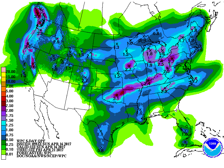
It still looks likely that the rainfall gradient will run from almost no rain across South Alabama to near one inch across the Tennessee River Valley counties. Drought conditions are worsening a bit since we’ve had no rain in Alabama for about a week.
Saturday, the upper closed low over the Texas Panhandle moves into Southwest Missouri with a surface low forecast to develop over northern Louisiana. The GFS and the Euro are much closer in their solutions on this run, but they still differ substantially on Saturday and Sunday. The Euro is drier than the GFS on Saturday and projects a surface low moving through the Ohio River Valley while the GFS brings a surface low across northern Alabama. With such big differences, confidence in the longer range forecast is not high, so we’ll stick with the ongoing forecast of rain chances going up on Saturday and fairly high for Sunday. Highs for next weekend are likely to be in the range of 79 to 84.
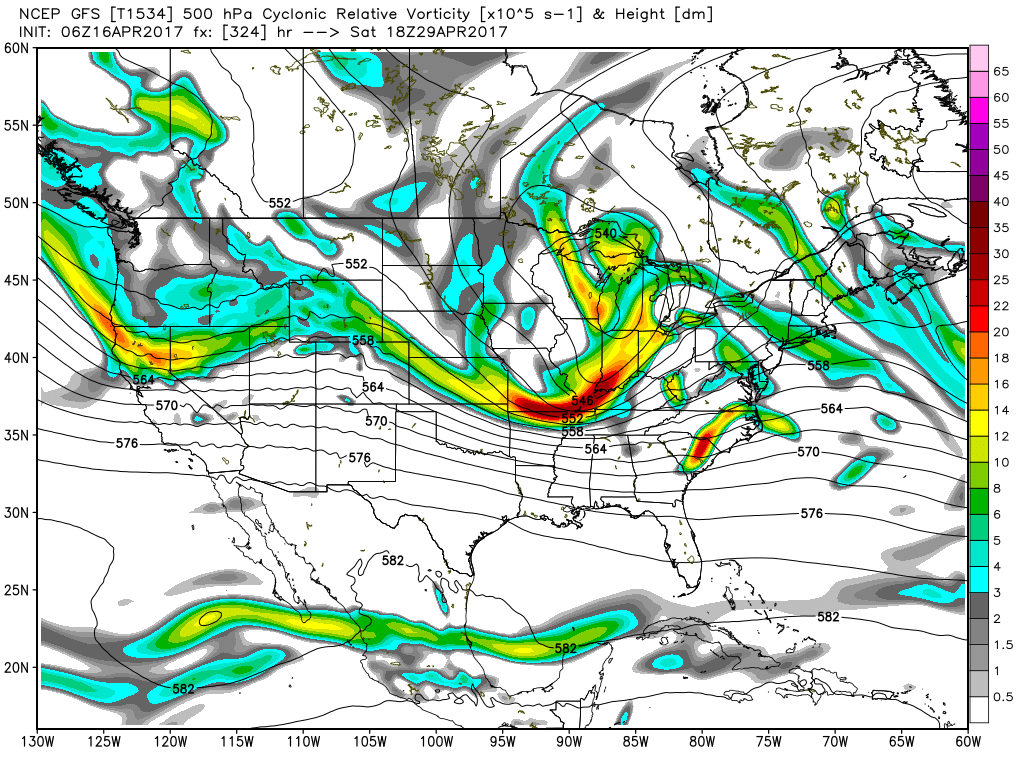
The GFS still maintains troughiness over the eastern US but the pattern does not look as chilly on this run as it did yesterday. The GFS is now suggesting a rather fast moving pattern with rapid changes. By the 27th of April, there is a short term ridge over the Southeast, but by the 29th a strong, digging short wave is forecast to move through the Middle Mississippi River Valley with a look that suggests a potential for severe weather. But as we enter May, the GFS projects a high amplitude ridge over the Mississippi River Valley with a big digging trough over southern California. But then this is voodoo country.
Weather looks pretty good at the beach. An isolated shower is possible today, otherwise the week ahead should be mostly dry. Lows will be in the 60s and highs in the upper half of the 70s. Click here to see the Beach Forecast Center page. Save Up To 25% on Spring Break Beach Vacations on the Alabama Gulf Coast with Brett/Robinson! The Beach Forecast is partially underwritten by the support of Brett/Robinson Vacation Rentals in Gulf Shores and Orange Beach. Click here to see Brett/Robinson’s best beach offers now!.
IT’S THAT TIME AGAIN! The Honda Indy Grand Prix will be April 21-23 at the beautiful Barber Motorsports Park! Make plans for the event that has been voted “Best Annual Event” and “Best Sporting Event” in Birmingham. Kids 15 & under are admitted free with a ticketed adult, and three-day general admission tickets are $69. Single day tickets are $15. Pack a picnic/cooler and bring the family out for a weekend full of activities and racing! Get tickets and more information here. The weather looks good for the first day of racing with some potential for showers and thunderstorms into the weekend. Get the detailed race cast here.
I had a great time at the Mutt Strut on Saturday. It’s always good to see the dogs get out with their owners for a good time. So many different dogs, too!! James Spann will be back on Monday morning with the next edition of the Weather Xtreme Video. Enjoy another summer-like day. Godspeed.
-Brian-
Category: Alabama's Weather, ALL POSTS, Weather Xtreme Videos
About the Author (Author Profile)
Brian Peters is one of the television meteorologists at ABC3340 in Birmingham and a retired NWS Warning Coordination Meteorologist. He handles the weekend Weather Xtreme Videos and forecast discussion and is the Webmaster for the popular WeatherBrains podcast.Subscribe
If you enjoyed this article, subscribe to receive more just like it.


