Physics for snow tomorrow
Just my two cents here on the physics of the potential snow event tomorrow over Mississippi and Alabama. James has been talking dynamic cooling and the upper-level low. I figured I’d go a little bit into what these are and how they may cause some snow tomorrow.
The upper-level low is when a wave in the upper-air flow gets cut off, or makes a complete loop. These often move slowly, unlike open waves in the flow that keep moving. Here is the low as it formed today and as it is expected to progress tomorrow on a 500 mb chart (about 18,000 feet).
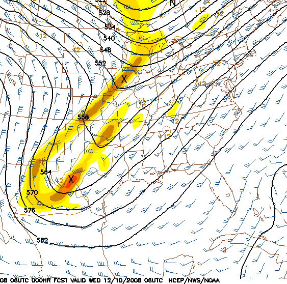
The solid lines are the heights of the 500 mb pressure surface, and the wind is typically parallel to these lines. As the temperature in the atmosphere cools, it becomes more dense, and the pressure changes more quickly with height. So, when cooling occurs, the height of the 500 mb surface typically gets lower. This is why cold air is usually associated with a trough and warm air is associated with a ridge.
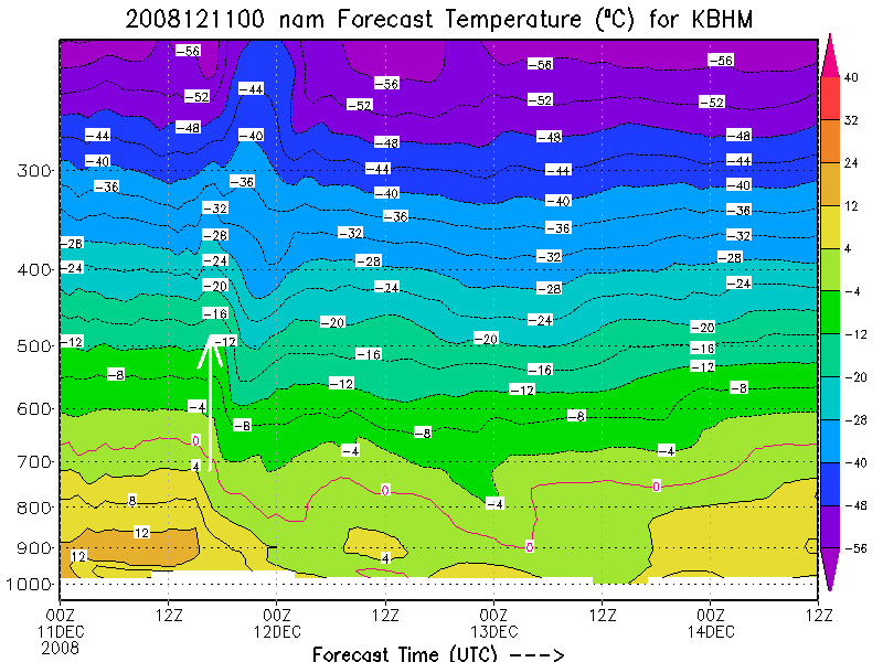
One thing that can cause a low to cutoff is dynamic cooling. This occurs when upward motion in the atmosphere causes it to cool. Notice the chart below of the predicted temperature vs. height and time at BHM. The air cools aloft where upward motion occurs.
Some of the cold air is also brought in by the wind. In this case, with Arctic air not in place, the cold air has to get down to the ground partly through the precipitation itself. Temperatures aloft are much colder than they are at the ground, and snow falling aloft brings cold air down with it, and causes cooling as it melts below the freezing level. The heavier the precipitation, the more cooling occurs. Eventually, the freezing level can get down close enough to the surface that snow doesn’t have time to melt before reaching the ground, and then the temperatures at the surface really start to cool, due to melting snow.
If the snow is heavy enough, initially warm surface temperatures can be overcome by large amounts of snow falling, cooling the air and accumulating faster than it can melt.
To pinpoint exactly where the snow will be is very tough, since it depends partially on where the heaviest precipitation occurs. Interestingly, the current model temperatures are running a little bit warmer already than observed temperatures. But, this may just be temporary. With all the competing factors going on (warm air coming in from the east, cold air from the west and aloft, melting), it’s a tough forecast. Both models agree that the heaviest precipitation will occur from central MS into north Alabama. What they don’t agree on is the amount of cooling. And, when 1 or 2 degrees makes such a difference, that’s tough. Right now, central Mississippi looks like the best spot for heavy snow. The heaviest precipitation may start to get a little farther north than the cold air as it moves into Alabama tomorrow afternoon (how often does that happen?). We’ll see.
Category: Uncategorized
About the Author (Author Profile)
Subscribe
If you enjoyed this article, subscribe to receive more just like it.


