Afternoon Update: Things Calming, No Repeat Tonight
A tornado watch continues for East Central and Northeast Alabama this afternoon. It is in effect until 7 p.m.
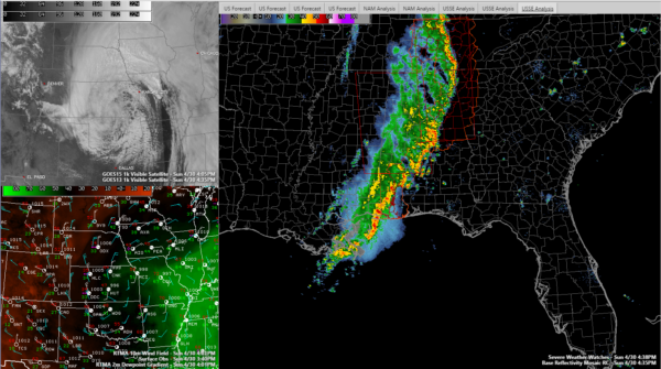
Fort Payne, Gadsden, Anniston, Clanton, Alex City and Selma are still in the watch.
Significant weather advisories are in effect for Chilton and Coosa counties in Central Alabama. The strongest storms are in Northeast Alabama’s Jackson and DeKalb counties. Those storm will move into Cherokee county shortly. Heavy rain, wind gusts to 40 mph and frequent lightning are the main threats.
Storms are strong across Coosa and Chilton Counties as well. Those counties also have a significant weather advisory. Again, lightning, heavy rain and strong gusty winds are the main threats.
Lots of lightning all the way from Ashville through Moody, Childersburg, Clanton, Billingsley and Selma.
Moderate rain extends back to the Alabama/Mississippi border.
Flooding does not appear to be a threat.
WILL THE ATMOSPHERE BE ABLE TO RELOAD?
Today’s system has really worked over the atmosphere across Alabama and Mississippi.
The cold front to our west if just passing over the Mississippi River. A few showers are showing up across western Tennessee and Northwest Mississippi, but they are weak still. Showers and maybe even a little thunder should develop tonight ahead of the front and push into West Alabama this evening. The showers and storms will push through overnight.
Tomorrow should feature partly cloudy skies, cooler temperatures in the 70s and a breezy southwesterly wind.
Category: Alabama's Weather, ALL POSTS
About the Author (Author Profile)
Bill Murray is the President of The Weather Factory. He is the site's official weather historian and a weekend forecaster. He also anchors the site's severe weather coverage. Bill Murray is the proud holder of National Weather Association Digital Seal #0001 @wxhistorianSubscribe
If you enjoyed this article, subscribe to receive more just like it.


