Conditions Around Central Alabama At The Midday Hour
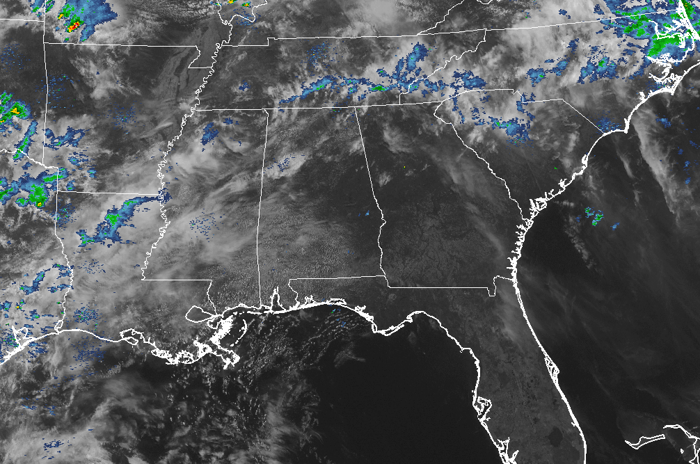
At the midday hour across Central Alabama, ridging in place over the southeast is keeping any rain out of our area. A few showers have moved through the extreme northern parts of the state earlier today, and a few are out there at this point as well, especially over parts of Lauderdale County near Zip City. For Central Alabama, we’re high and dry with a mix of sun and clouds at this point.
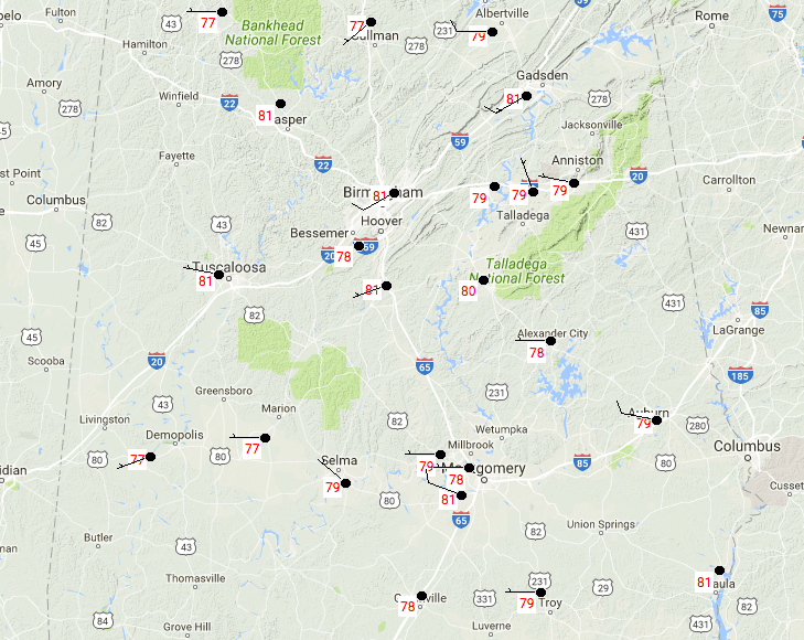
Temperatures across Central Alabama at 11:27AM are running in the upper 70s to the lower 80s. A few locations are currently tied for the warmest at 81 degrees, to go along with a few locations tied for the coolest at 77 degrees.
AIR QUALITY CHECK
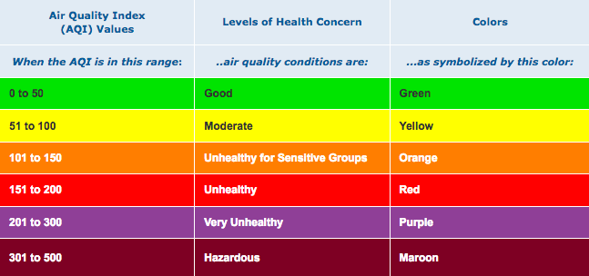
The Air Quality Index for the Birmingham Metropolitan area will be in a CODE YELLOW (MODERATE) at 71 due to increased levels of Ozone and Particulate Matter (PM2.5). Unusually sensitive people should consider reducing prolonged or heavy exertion outdoors.
REMAINDER OF THURSDAY’S WEATHER
Throughout the remainder of the daytime hours, clouds will be on the increase but we should stay dry. Afternoon highs will top out in the upper 80s to the lower 90s across Central Alabama from north to south. Later this evening, there will be a small risk for a few showers moving across the western parts of the area, especially after 8PM. Those showers will spread out over the northern parts of Central Alabama for the overnight hours, sometime before midnight according to the latest HRRR, but will quickly move to the northeast of of the area within a couple of hours. Overnight lows will be in the lower to mid 60s.
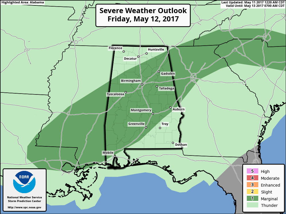
A FEW STRONG STORMS POSSIBLE ON FRIDAY
The morning will start off with some showers moving mainly over the northwestern parts of the area before dawn, then some heavier showers and storms will develop and move across the northern half of the area during the morning through the early afternoon hours. Surface based instability levels will be lower during this time, and storm relative helicity will be low as well. A few strong storms could be possible at this time, with gusty winds as the main threat.
The larger threat for strong to marginally severe storms will come later during the late afternoon through the midnight hour across Central Alabama, as more storms will have developed due to the heating of the day, and with the surface-based instability values being much higher, topping out in the 2,700-3,400 J/kg range. The overall risk will remain marginal for severe storms with gusty winds and some small hail as the main threats. The low-level flow and storm-relative helicity values look to be too low for any tornadoes.
So the bottom line for the day, skies will be cloudy throughout the entire day, with showers and thunderstorms likely. Strong to marginally severe storms will be possible during the afternoon and early evening hours, with gusty winds and small hail as the main threats. Afternoon highs will be in the mid 70s to the mid 80s. Rainfall amounts of 1/2 inch are likely, with some isolated higher totals possible. Rain and storms will continue in the evening and overnight hours, but will be out of the area by early Saturday morning. Overnight lows will be in the upper 50s to the mid 60s.
BEACHBOUND
If you would like to see what the weather holds for Ft. Morgan over to Panama City Beach, click here to see the Beach Forecast Center page. Save Up To 25% on Spring Break Beach Vacations on the Alabama Gulf Coast with Brett/Robinson! The Beach Forecast is partially underwritten by the support of Brett/Robinson Vacation Rentals in Gulf Shores and Orange Beach. Click here to see Brett/Robinson’s best beach offers now!
THIS DAY IN WEATHER HISTORY – May 11, 1970
A very powerful tornado struck the city of Lubbock, TX, killing 26 persons, injuring more than 500 others, and causing 135 million dollars damage. It was the most destructive tornado of record up until that time, and came on the 17th anniversary of the twister which struck Waco TX killing 114 persons. A second tornado killed two others persons in Lubbock, and the two tornadoes damaged or destroyed nearly a quarter of the city.
Category: Alabama's Weather, ALL POSTS
About the Author (Author Profile)
Scott Martin is an operational meteorologist, professional graphic artist, musician, husband, and father. Not only is Scott a member of the National Weather Association, but he is also the Central Alabama Chapter of the NWA president. Scott is also the co-founder of Racecast Weather, which provides forecasts for many racing series across the USA. He also supplies forecasts for the BassMaster Elite Series events including the BassMaster Classic.Subscribe
If you enjoyed this article, subscribe to receive more just like it.


