Showers/Storms Return Tomorrow Afternoon/Night
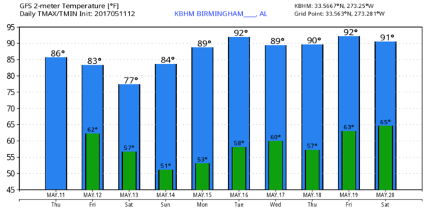
WARM, DRY AFTERNOON: With sunshine through high cirrus clouds, temperatures are mostly in the mid 80s across the great state of Alabama this afternoon. Nothing on radar here, but we are monitoring strong to severe storms west of the state over Oklahoma and Arkansas.
Clouds increase across Alabama tonight, and a few showers could reach the northwest corner of the state after midnight, but they should be in a dissipating stage.
TOMORROW: SPC has a “marginal risk” of severe storms up for much of Alabama, for areas south of a line from Vernon to Vinemont to Scottsboro…
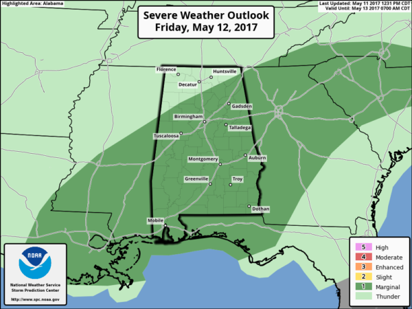
Latest guidance now suggests the primary window for showers and storms will come from about 12:00 noon tomorrow through 3:00 a.m. Saturday. That doesn’t mean it will rain the entire time, but expect a few passing showers and strong thunderstorms. The most widespread rain will most likely come from 6:00 p.m. through midnight.
There will be a decent amount of instability available for mid-May (surface based CAPE values around 3,000 j/kg by mid-afternoon), but wind fields are expected to be weak, with very marginal lapse rates. Heavier storms could produce small hail and strong gusty winds, but no tornado activity is expected. Rain amounts should average around 1/2 inch, with isolated heavier amounts.
THE ALABAMA WEEKEND: Early morning clouds Saturday will give way to a mostly sunny afternoon; the high will be in the 75-78 degree range, a little below average for the middle of May. Sunday will be warmer with a good supply of sunshine; the high will be up in the mid 80s.
NEXT WEEK: A deep, cold core upper low will park over the western U.S… and we will be under the downstream ridge. This means the entire week will be dry with warm/hot afternoons; highs between 87 and 90 days with lows in the 60s. See the Weather Xtreme video for maps, graphics, and more details.
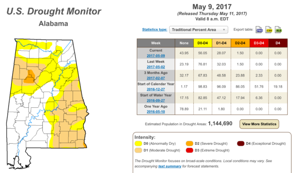
DROUGHT MONITOR: New data released this morning shows drought conditions continuing to ease across Alabama…
But, remember, we are forecasting dry conditions for at least 7 consecutive days beginning Saturday.
Click here to see the Beach Forecast Center page. Save Up To 25% on Spring Break Beach Vacations on the Alabama Gulf Coast with Brett/Robinson! The Beach Forecast is partially underwritten by the support of Brett/Robinson Vacation Rentals in Gulf Shores and Orange Beach. Click here to see Brett/Robinson’s best beach offers now!
WEATHER BRAINS: Don’t forget you can listen to our weekly 90 minute netcast anytime on the web, or on iTunes. This is the show all about weather featuring many familiar voices, including our meteorologists here at ABC 33/40.
CONNECT: You can find me on all of the major social networks…
Facebook
Twitter
Google Plus
Instagram
Pinterest
Snapchat: spannwx
I enjoyed seeing the second graders today at Alexandria Elementary School in Calhoun County… be looking for them on the Pepsi KIDCAM today at 5:00 on ABC 33/40 News! The next Weather Xtreme video will be posted here by 7:00 a.m. tomorrow…
Category: Alabama's Weather, ALL POSTS, Weather Xtreme Videos
About the Author (Author Profile)
James Spann is one of the most recognized and trusted television meteorologists in the industry. He holds the AMS CCM designation and television seals from the AMS and NWA. He is a past winner of the Broadcast Meteorologist of the Year from both professional organizations.Subscribe
If you enjoyed this article, subscribe to receive more just like it.


