Threat of Tropical Tornadoes Continues
UPDATE 151 PM
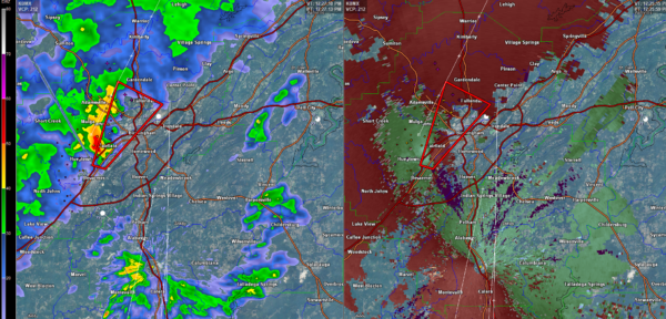
Rotation near Vincent in NE Shelby County. That will push to just west of Pell City just after 2 p.m.
No warnings at this time.
All storms today are capable of producing tornadoes because of significant low level shear.
They are also moving very very fast in the fast flow aloft.
Two main areas of concern right now.
BIBB COUNTY MOVING INTO SHELBY COUNTY/SOUTHWEST JEFFERSON
Storms over Bibb County are quite intense. They are just west of Centerville. They will push northeast into western Shelby County and western Jefferson County. Bessemer and McCalla are in the path again. Centreville, Marvel and Maylene are also in the path, and will move just west of Alabaster and near Pelham. It will reach Pelham around 2:30 p.m.
EASTERN SHELBY MOVING INTO ST. CLAIR
Strong storms are near Harpersville. They will cross I-20 near and west of Pell City shortly. FOlks in Odenville and WAttsville need to be vigilant too.
BE READY
These storms can produce spin up tornadoes very quickly and warnings and you may only have seconds when a warning is issued.
HEAVY RAIN
The storms are all producing torrential rains. Be prepared for flooding to occur.
Category: Alabama's Weather, ALL POSTS
About the Author (Author Profile)
Bill Murray is the President of The Weather Factory. He is the site's official weather historian and a weekend forecaster. He also anchors the site's severe weather coverage. Bill Murray is the proud holder of National Weather Association Digital Seal #0001 @wxhistorianSubscribe
If you enjoyed this article, subscribe to receive more just like it.


