

A Look At Today’s Severe Weather & Flooding Threat
A collaborative post by Bill Murray and Scott Martin.

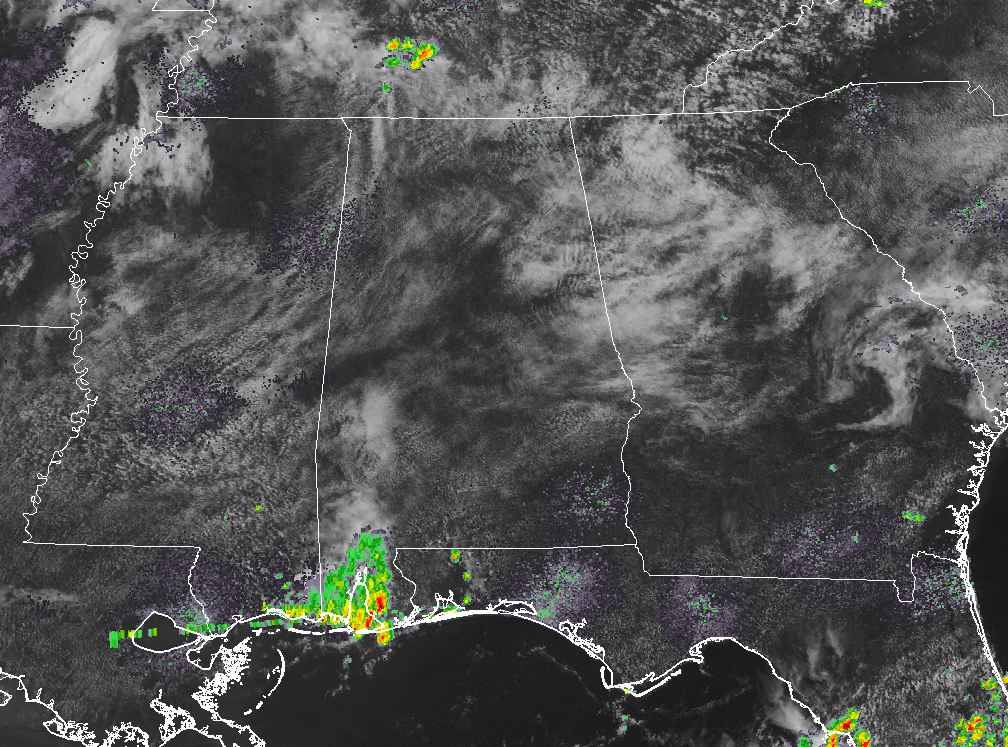
We have both a severe weather threat and a flash flooding threat across parts of North and Central Alabama on this first of July.
A moist, unstable atmosphere and a strong upper level trough to our northwest will conspire to bring a round of showers and storms that will commence by early afternoon and spread southeastward through the balance of the day.
While the Gulf of Mexico is not wide open for business, the airmass over the state is still very moist. The precipitable water value on the morning sounding from the Shelby County Airport was 1.88 inches, which is still plenty humid. Dewpoints are in the lower 70s.
Skies are becoming partly cloudy to mostly sunny in most spots, which will allow the sun to push the mercury into the upper 80s. This would be enough to trigger storms even without the encroaching trough.
Surface CAPE values will reach 2500-3500 j/kg. This is substantial instability which will mean strong updrafts and strong storms.
Wind shear is weak (effective shear around 14 knots) so the storms should be more of the pulse variety, meaning they pop up and then rain themselves out very quickly, but as they do, they can produce strong downbursts of air that can cause damaging winds. That will be the primary threat. Helicity values are low meaning no tornado threat.
To get those downbursts, you need dry air in the mid levels. That is present this morning, and could dry out even more as we go through the day. This is contributing to Downdraft CAPE values around 1,000 joules/kg, which is significant.

Latest NAM 3-k is showing development starting after the 2PM hour and greatly increasing throughout the evening hours, and not settling down until the very early morning hours on Sunday. Localized rainfall amounts of up to 2 inches could be possible under a few of the heavier storms.
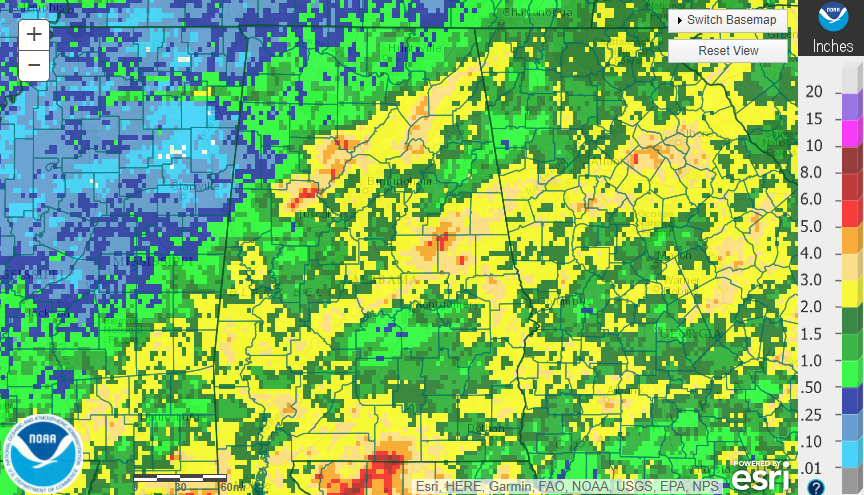
Of course, we have had lots of recent rain with 7 day amounts between 1 and 2 inches common across all except extreme West Alabama. Parts of northern Tuscaloosa, Walker and southern Cullman Counties have seen 4-6 inches!! This is on top of what fell from Tropical Storm Cindy the previous week. Another bullseye is over East Central Alabama’s Coosa, Clay and Tallapoosa counties, where over five inches has fallen in spots.

Flash flood guidance values are between 1.7 and 2.4 inches per hour, and around 2-2.5 inches in 3 hours and less than 3 inches in six hours. Those sort of rainfall amounts could definitely fall with the moist airmass in place today. Accordingly, the NWS has posted flash flood watches for North Central and Northeast Alabama, including Blount, Calhoun, Cherokee, Etowah, Jefferson, St. Clair, Walker and Winston Counties and Cullman, De Kalb, Jackson, Marshall and Morgan counties until midnight tonight.
We will have frequent updates and immediate alerts for warnings here on the AlabamaWX blog.
Category: Alabama's Weather, ALL POSTS
About the Author (Author Profile)
Scott Martin is an operational meteorologist, professional graphic artist, musician, husband, and father. Not only is Scott a member of the National Weather Association, but he is also the Central Alabama Chapter of the NWA president. Scott is also the co-founder of Racecast Weather, which provides forecasts for many racing series across the USA. He also supplies forecasts for the BassMaster Elite Series events including the BassMaster Classic.Subscribe
If you enjoyed this article, subscribe to receive more just like it.


