

Possible Severe Thunderstorm Watch Coming For North Alabama
The Storm Prediction Center is mentioning the possibility of issuing a Severe Thunderstorm Watch for northern Alabama, northern Georgia, middle through eastern Tennessee, southern Kentucky, and western North Carolina.
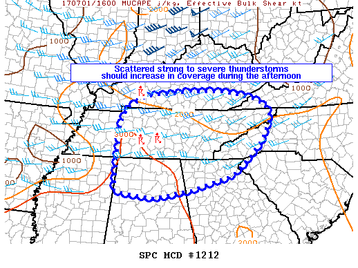
Scattered storms should increase in intensity and coverage over the course of the afternoon, with hail and damaging wind potential increasing. A Severe Thunderstorm Watch may be needed this afternoon. Possibility is currently at 60%.
Here is the text of the Mesoscale Discussion…
Isolated thunderstorms have developed in western Kentucky and middle Tennessee over the past couple of hours. These storms are in an environment characterized by modest deep shear profiles (25-30 knots) and moderate to strong instability (2000-3000 J/kg MUCAPE), with forcing for ascent provided by subtle low-level convergence (westerly to southwesterly low-level flow) and the glancing influence of a mid-level shortwave trough over Indiana aiding in ongoing convective development.
Models and observations support a gradual, yet continued increase in convective coverage over the course of the afternoon, with an attendant increase in damaging wind and marginally severe hail potential – especially in eastern Tennessee. Convective trends are being monitored, and a severe thunderstorm watch may be needed for parts of the region later this afternoon.
Category: Alabama's Weather, ALL POSTS
About the Author (Author Profile)
Scott Martin is an operational meteorologist, professional graphic artist, musician, husband, and father. Not only is Scott a member of the National Weather Association, but he is also the Central Alabama Chapter of the NWA president. Scott is also the co-founder of Racecast Weather, which provides forecasts for many racing series across the USA. He also supplies forecasts for the BassMaster Elite Series events including the BassMaster Classic.Subscribe
If you enjoyed this article, subscribe to receive more just like it.


