

Severe Thunderstorm Warning Continues For Parts Of Calhoun And Cherokee Counties Until 4:30PM

…A SEVERE THUNDERSTORM WARNING REMAINS IN EFFECT UNTIL 430 PM CDT FOR NORTHEASTERN CALHOUN AND SOUTHEASTERN CHEROKEE COUNTIES… At 419 PM CDT, severe thunderstorms were located along a line extending from Forney to near Piedmont to Weaver, moving east at 35 mph.
HAZARD…60 mph wind gusts and penny size hail.
SOURCE…Radar indicated.
IMPACT…Expect damage to roofs, siding, and trees. Locations impacted include… Anniston, Jacksonville, Piedmont, Forney, Saks, Weaver, Pleasant Gap, Jacksonville State University, Alexandria, Coloma, Knightens Crossroads and Spring Garden.
Severe Thunderstorm Warning Canceled For Parts Of Etowah County
Jul 6th @ 3:43 pm
…THE SEVERE THUNDERSTORM WARNING FOR EAST CENTRAL ETOWAH COUNTY IS CANCELLED… The storms which prompted the warning have moved out of the warned area. Therefore, the warning has been cancelled.
Severe Thunderstorm Warning Continues For Parts Of Calhoun, Cherokee, And Etowah Counties Until 4:30PM
Jul 6th @ 3:43 pm

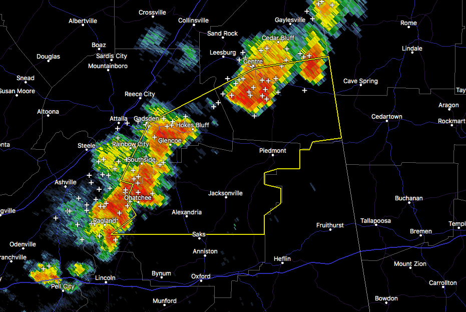
…A SEVERE THUNDERSTORM WARNING REMAINS IN EFFECT UNTIL 430 PM CDT FOR NORTHERN CALHOUN…EAST CENTRAL ETOWAH AND SOUTHERN CHEROKEE COUNTIES… At 412 PM CDT, severe thunderstorms were located along a line extending from near Forney to near Ball Flat to near Alexandria, moving east at 35 mph.
HAZARD…60 mph wind gusts and penny size hail.
SOURCE…Radar indicated.
IMPACT…Expect damage to roofs, siding, and trees. Locations impacted include… Anniston, Jacksonville, Piedmont, Hokes Bluff, Forney, Saks, Weaver, Ohatchee, Tennala, Pleasant Gap, Alexandria, Jacksonville State University, Ball Flat, Moshat, Coloma, Spring Garden, Knightens Crossroads, Sulphur Springs, Reaves and Wellington.
Severe Thunderstorm Warning Continues For Parts Of Calhoun, Cherokee, And Etowah Counties Until 4:30PM
Jul 6th @ 3:43 pm

…A SEVERE THUNDERSTORM WARNING REMAINS IN EFFECT UNTIL 430 PM CDT FOR CALHOUN…SOUTHEASTERN ETOWAH AND SOUTHERN CHEROKEE COUNTIES… At 358 PM CDT, severe thunderstorms were located along a line extending from near Moshat to Hokes Bluff to near Ohatchee, moving east at 35 mph.
HAZARD…60 mph wind gusts and penny size hail.
SOURCE…Radar indicated.
IMPACT…Expect damage to roofs, siding, and trees. Locations impacted include… Anniston, Jacksonville, Piedmont, Hokes Bluff, Centre, Forney, Saks, Glencoe, Weaver, Ohatchee, Tennala, Pleasant Gap, Alexandria, Jacksonville State University, Ballplay, Moshat, Ball Flat, Southside, Coloma and Spring Garden.
Severe Thunderstorm Warning Issued For Parts Of Calhoun, Cherokee, And Etowah Counties Until 4:30PM
Jul 6th @ 3:43 pm
Heads up for these severe thunderstorms as wind gusts could reach up as high as 60 MPH. Seek shelter if you are in the path of this storm.

The National Weather Service in Birmingham has issued a
* Severe Thunderstorm Warning for…
Calhoun County in east central Alabama…
Southeastern Etowah County in northeastern Alabama…
Southern Cherokee County in northeastern Alabama…
* Until 430 PM CDT
* At 342 PM CDT, severe thunderstorms were located along a line extending from Tennala to near Glencoe to near Ragland, moving east at 35 mph.
HAZARD…60 mph wind gusts and penny size hail.
SOURCE…Radar indicated.
IMPACT…Expect damage to roofs, siding, and trees.
* Locations impacted include…
Gadsden, Anniston, Jacksonville, Rainbow City, Piedmont, Hokes
Bluff, Centre, Forney, Saks, Glencoe, Weaver, Ohatchee, Tennala, Pleasant Gap, Alexandria, Jacksonville State University, Ballplay, Gadsden Mall, Moshat and Ball Flat.
Category: ALL POSTS, Archived Warnings
About the Author (Author Profile)
Subscribe
If you enjoyed this article, subscribe to receive more just like it.


