

A Midday Look At Central Alabama’s Weather
A Little More Settled At Midday
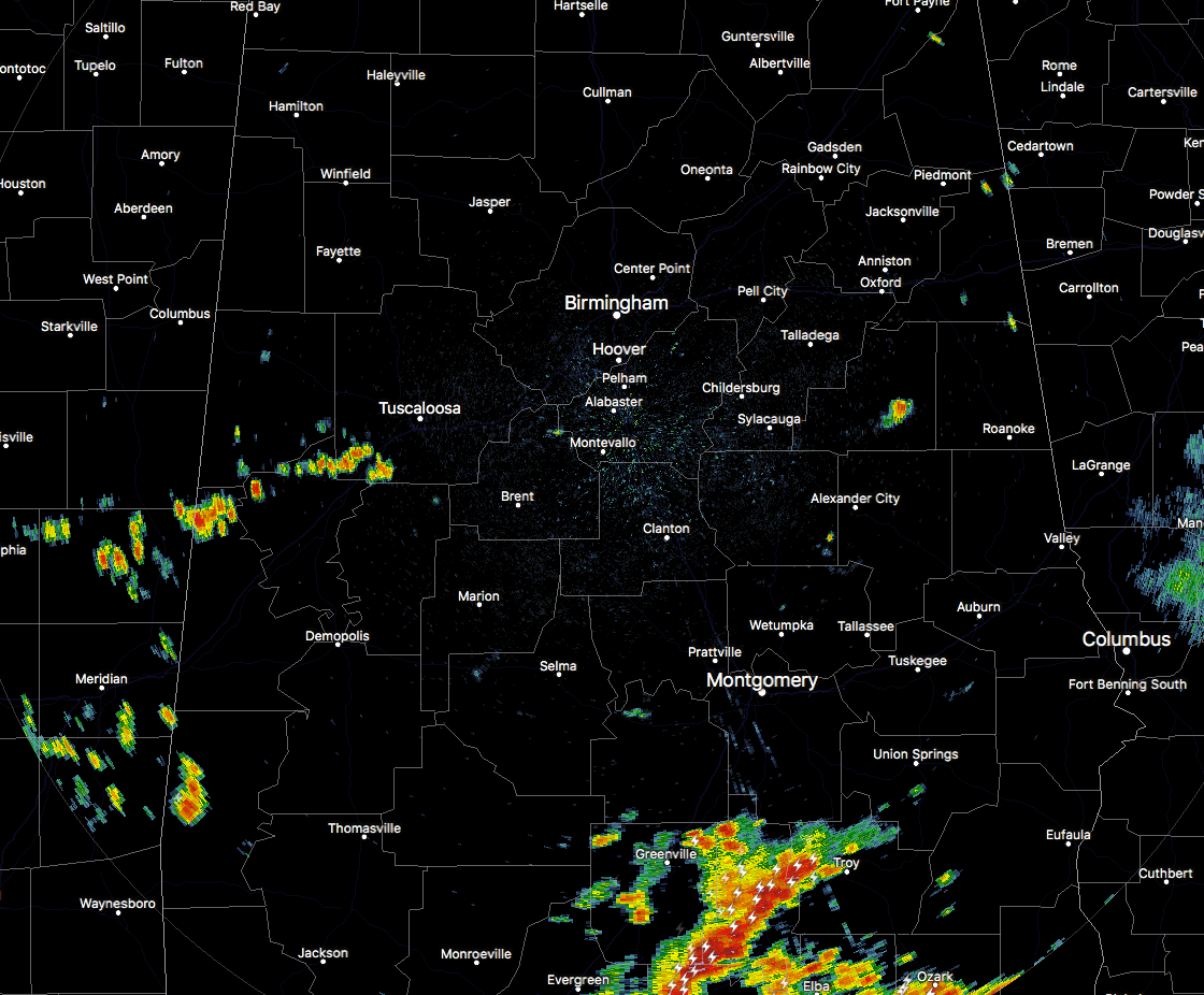
After a morning that featured torrential rains over portions of Central Alabama, much of the area across the area is quiet at this time. That is good news at this point considering the flooding that was taking place in parts of Jefferson and Shelby counties. Some of the rainfall totals that have been submitted to NWS Birmingham has ranged from 4-6 inches so far, with the highest total of 6.39 inches very close to Alabama Splash Adventure in Bessemer.
There are some storms occurring over the southern portions of the state that are putting down heavy downpours at this point. The northern part of this cluster is reaching into the northern parts of Pike County. Elsewhere across the area, just a few spotty showers are out there.
Temperatures Across Central Alabama
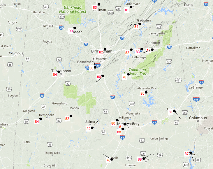
With the cloud cover and rain-cooled air over parts of Central Alabama, temperatures are in the upper 70s to the upper 80s across the area at 12:25 PM. The cool spot is Alexander City at 78 degrees, with the warm spot being 88 degrees at Troy. Hard to believe that Jasper is at 90 degrees with other nearby locations in the lower 80s.
Hot, Humid, Scattered Storms Throughout The Rest Of Today
Not quite as hot, but still really humid, with mostly cloudy skies and a risk of scattered mainly afternoon and evening showers and storms. Chances will be a little higher in the southern half due to a surface front over the central part of the state, but it will not be an all day wash out, and not everyone will get rain. Afternoon highs will be in the middle the to upper 80s throughout the area. If you’re caught under one of these storms, expect very heavy rainfall and dangerous cloud-to-ground lightning. Go indoors when thunder roars. If you hear thunder, you are close enough to be struck by lightning.
Monday’s Weather… Should I Just “Copy & Paste” From Today’s
It will be another really warm and humid, with a risk of scattered mainly afternoon and evening showers and storms. Chances will be a little higher in the southern half with the stalled surface front over the central part of the state. Highs will be in the upper 80s to the lower 90s throughout the area.
May Dry Out For A Little While
Troughing in the Great Lakes region will help move the stalled front southward and will bring drier air in for Tuesday. It will be mostly sunny with highs in the lower 90s. On Wednesday through the beginning of the weekend, we will have a ridging across the southeastern states, bringing up the heat levels and a return of a very small risk for isolated showers or storms. Days will be mostly sunny and highs will be in the lower to mid-90s throughout much of the area, with upper 90s possible on Thursday.
Got Beach Plans?
Mainly sunny with temperatures in the upper 80s to the lower 90s along the Gulf. Of course each day there are passing storms moving onshore with the sea breeze. We do note, with the front stalling along the coast, rain chances will be higher at times for the week ahead, but still overall a great week of weather at the beach. For a detailed look at the weather from Fort Morgan over to Panama City Beach, click here to see the AlabamaWx Beach Forecast Center page.
The Beach Forecast is partially underwritten by the support of Brett/Robinson Vacation Rentals in Gulf Shores and Orange Beach. Click here to see Brett/Robinson’s “Own Your Summer” specials now!
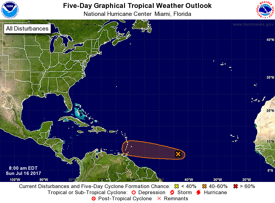
Tropical Outlook
A westward-moving trough of low pressure is located about 1000 miles east-southeast of the Windward Islands continues to produce
disorganized showers and thunderstorms. There could be some development of this system before it reaches the Lesser Antilles in two to three days. After that, less favorable upper-level winds are expected to hinder additional development. It has around a 40% chance of forming into a tropical cyclone within the next 5 days.
Today In Weather History
July 16, 1989 – Showers and thunderstorms developing along a stationary front drenched the Middle Atlantic Coast States with heavy rain, causing flooding in some areas. More than five inches of rain was reported near Madison and Ferncliff, VA. Hot weather prevailed in Texas. San Angelo reported a record high of 106 degrees.
WeatherBrains
Don’t forget you can listen to our weekly 90 minute netcast anytime on the web, or on iTunes. This is the show all about weather featuring many familiar voices, including our meteorologists here at ABC 33/40. you can watch it live here on Monday nights at 8:30PM CDT.
Advertise With AlabamaWx… You Can’t Go Wrong
Deliver your message to a highly engaged audience by advertising on the AlabamaWX.com website. The site has already enjoyed 9.6 MILLION page views so far this year alone. Don’t miss out! We can customize a creative, flexible and affordable package that will suit your organization’s needs. Contact Bill Murray at (205) 687-0782.
Category: Alabama's Weather, ALL POSTS
About the Author (Author Profile)
Scott Martin is an operational meteorologist, professional graphic artist, musician, husband, and father. Not only is Scott a member of the National Weather Association, but he is also the Central Alabama Chapter of the NWA president. Scott is also the co-founder of Racecast Weather, which provides forecasts for many racing series across the USA. He also supplies forecasts for the BassMaster Elite Series events including the BassMaster Classic.Subscribe
If you enjoyed this article, subscribe to receive more just like it.


