Drier Air Rolls In Over The Weekend
RADAR CHECK: We have patches of mostly light rain on radar at mid-afternoon; the large rain mass that moved across North Alabama earlier today is now in Georgia. Very little lightning showing up as well.
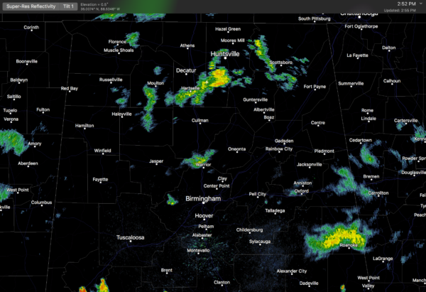
With a rather rare mid-summer surface front due in here tonight, the NWS is going to continue the flash flood watch for the northern half of the state through midnight since a few thunderstorms could form over the next 6-8 hours. And, SPC has roughly the northern two-thirds of the state in a “marginal risk” of severe weather; a few of the storms could produce strong gusty winds. But, the air over North Alabama is mostly stable and rain-cooled, so the overall severe weather threat looks very low for now.
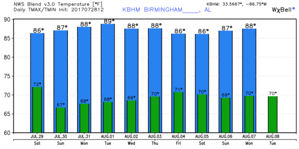
THE WEEKEND: The front will drop down to near U.S. 80 tomorrow morning; showers and storms will be confined to the far southern counties of the state as drier air works into North and Central Alabama. For places like Birmingham, Tuscaloosa, Anniston, and Gadsden, morning clouds will give way to a sunny afternoon with a high between between 85 and 88. Then, on Sunday, look for mostly sunny and less humid weather with a high in the upper 80s.
NEXT WEEK: The weather looks very quiet for the first half of the week; mostly sunny days and fair nights with few if any showers Monday through Wednesday. Looks like showers and storms will return at the end of the week on Friday with another upper trough forming over the eastern third of the nation; see the Weather Xtreme video for maps, graphics, and more details.
TROPICS: All is quiet across the vast Atlantic basin, and tropical storm formation is not expected over the next seven days.
BEACH FORECAST: Click here to see the AlabamaWx Beach Forecast Center page. The Beach Forecast is partially underwritten by the support of Brett/Robinson Vacation Rentals in Gulf Shores and Orange Beach. Click here to see Brett/Robinson’s Own Your Summer specials now!
WEATHER BRAINS: Don’t forget you can listen to our weekly 90 minute netcast anytime on the web, or on iTunes. This is the show all about weather featuring many familiar voices, including our meteorologists here at ABC 33/40.
CONNECT: You can find me on all of the major social networks…
Facebook
Twitter
Google Plus
Instagram
Pinterest
Snapchat: spannwx
I will be on vacation next week… my next Weather Xtreme video will be posted here Monday morning August 7… Brian Peters will be handling the videos each day in my place. Enjoy the weekend!
Category: Alabama's Weather, ALL POSTS, Weather Xtreme Videos
About the Author (Author Profile)
James Spann is one of the most recognized and trusted television meteorologists in the industry. He holds the AMS CCM designation and television seals from the AMS and NWA. He is a past winner of the Broadcast Meteorologist of the Year from both professional organizations.Subscribe
If you enjoyed this article, subscribe to receive more just like it.


