

Soggy Summer Weather Pattern
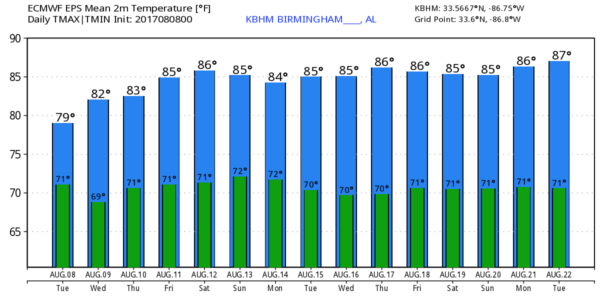
WET AT TIMES: A fairly large rain mass covers much of Central Alabama early this morning, and we will maintain a good chance of rain at times through tonight as copious amounts of tropical moisture continue in the air over our state. Some thunder is possible as well, but severe weather is not expected. Like yesterday, we won’t get out of the 80s because of clouds and showers.
There is a surface front this morning near the Alabama/Tennessee border; this will creep southward, and slightly drier air will slip into the far northern part of the state this afternoon. So, if you are in Huntsville, Florence, or Scottsboro, there is a decent chance much of the afternoon will be rain-free. But again, for the rest of the state, periods of rain are likely.
REST OF THE WEEK: The surface front will ease northward tomorrow and dissipate, and a deep layer of moisture will stay parked across the Deep South, meaning the unsettled summer weather will continue. Each day will feature a mostly cloudy sky with a good chance of rain at times and a few thunderstorms. I would not be surprised to see a flash flood watch issued for parts of the state before the week is over; rain amounts between now and Friday should be in the 2 to 4 inch range.
On the positive side, we won’t have to deal with the typical scorching heat we expect in August; highs will remain in the 80s. In fact, there is no sign of any 90 degree heat through early next week.
THE WEEKEND: Same situation; the soggy setup continues. Deep tropical moisture and a broad trough aloft will mean scattered to numerous showers and thunderstorms Saturday and Sunday. Understand there will be some good breaks in the rain, and you might even see a few peeks of sun, but just be ready for a shower or storm at just about any hour of the day or night.
NEXT WEEK: The GFS is hinting that drier air could filter into the northern half of Alabama by Tuesday; if by chance this verifies our weather will trend drier and hotter by mid-week. But, that is just an idea that could very well come back off the table in coming days. See the Weather Xtreme video for maps, graphics, and more details.
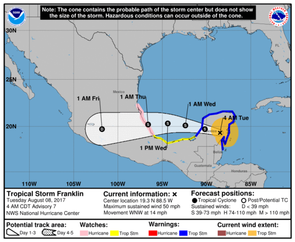
FRANKLIN IS INLAND FOR NOW: Tropical Storm Franklin is over the Yucatan Peninsula of Mexico early this morning with sustained winds of around 50 mph. It will come back out over the Bay of Campeche in the far southwest Gulf of Mexico tonight, and make a second landfall late tomorrow night or Thursday morning on the Mexican coast, well south of Brownsville, Texas. There is a chance this becomes the first hurricane of the season in the Atlantic basin tomorrow.
We should point out that Franklin will not impact the northern Gulf of Mexico at all; no issues for the Alabama or Northwest Florida Gulf Coasts.
Another weak disturbance is over the Central Atlantic, about halfway between the coast of Africa and the Lesser Antilles, but it is fighting shear and dry air, and odds of survival for now look pretty low.
BEACH FORECAST: Click here to see the AlabamaWx Beach Forecast Center page. The Beach Forecast is partially underwritten by the support of Brett/Robinson Vacation Rentals in Gulf Shores and Orange Beach. Click here to see Brett/Robinson’s Own Your Summer specials now!
WEATHER BRAINS: Don’t forget you can listen to our weekly 90 minute netcast anytime on the web, or on iTunes. This is the show all about weather featuring many familiar voices, including our meteorologists here at ABC 33/40.
CONNECT: You can find me on all of the major social networks…
Facebook
Twitter
Google Plus
Instagram
Pinterest
Snapchat: spannwx
I will be speaking to the senior adults today at Eden Westside Baptist Church in Pell City… look for the next Weather Xtreme video here by 4:00 this afternoon. Enjoy the day!
Category: Alabama's Weather, ALL POSTS, Weather Xtreme Videos
About the Author (Author Profile)
James Spann is one of the most recognized and trusted television meteorologists in the industry. He holds the AMS CCM designation and television seals from the AMS and NWA. He is a past winner of the Broadcast Meteorologist of the Year from both professional organizations.Subscribe
If you enjoyed this article, subscribe to receive more just like it.


