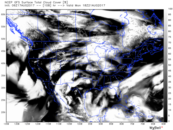
A Few Scattered Storms This Afternoon
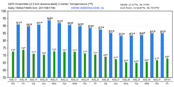
DOG DAYS OF SUMMER: Fairly routine weather for August continues today and tomorrow across the great state of Alabama; partly sunny days with a few scattered showers and thunderstorms during the afternoon and evening hours. Highs pretty close to 90 degrees. Chance of any one spot getting wet both days is around 30 percent.
DRIER AIR FOR THE WEEKEND: We expect a surge of drier air dropping down into the northern half of Alabama over the weekend, meaning few, if any showers, a good supply of sunshine, and hotter afternoons. Temperatures will creep up toward the mid 90s Saturday and Sunday, reminding us we are still in a very hot part of summer. Even down in South Alabama showers and storms should be pretty widely scattered.
ECLIPSE MONDAY: Generally speaking, the weather is looking pretty good for eclipse viewing in Alabama. It begins around 12:00 noon, peaks around 1:30, and ends at 3:00… there will be a field of cumulus clouds, but no sign of any widespread cloud cover that would block your view. Any showers during that three hour window should be few and far between.
Many are having issues finding safe glasses for eclipse viewing; I have a thread going on my Facebook page that might give you some ideas.
REST OF NEXT WEEK: Moisture levels creep upward through mid-week with scattered showers and storms returning… see the Weather Xtreme video for maps, graphics, and more details.
TROPICS: Hurricane Gert is accelerating into the North Atlantic, and will become post tropical in coming days. We also have three tropical waves to watch from the Lesser Antilles to the coast of Africa…
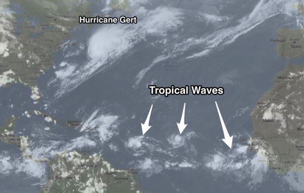
INVEST 91L: The lead wave has a high chance of becoming Tropical Storm Harvey in coming days; it will move across the Caribbean, and there is high likelihood this moves into Central America in 5 days or so.
INVEST 92L: The trailing wave will take a higher latitude course, and should be near the Bahamas early next week. It will encounter some rather harsh environmental conditions, and global models suggest it might not survive after Monday or Tuesday. Still lots of uncertainty here.
WAVE THREE: This will most likely become “Invest 93L” later today; a medium chance of development over the next five days as it makes the long journey westward across the Atlantic.
Despite all of this action, global models show no tropical issues for the Gulf of Mexico for the next 10 days.
BEACH FORECAST: Click here to see the AlabamaWx Beach Forecast Center page. The Beach Forecast is partially underwritten by the support of Brett/Robinson Vacation Rentals in Gulf Shores and Orange Beach. Click here to see Brett/Robinson’s Hot Deals now!
WEATHER BRAINS: Don’t forget you can listen to our weekly 90 minute netcast anytime on the web, or on iTunes. This is the show all about weather featuring many familiar voices, including our meteorologists here at ABC 33/40.
CONNECT: You can find me on all of the major social networks…
Facebook
Twitter
Google Plus
Instagram
Pinterest
Snapchat: spannwx
Look for the next Weather Xtreme video here by 4:00 this afternoon… enjoy the day!
Category: Alabama's Weather, ALL POSTS, Weather Xtreme Videos
About the Author (Author Profile)
James Spann is one of the most recognized and trusted television meteorologists in the industry. He holds the AMS CCM designation and television seals from the AMS and NWA. He is a past winner of the Broadcast Meteorologist of the Year from both professional organizations.Subscribe
If you enjoyed this article, subscribe to receive more just like it.


