A Few Showers Possible Sunday; Harvey Close To Texas
THE ALABAMA SITUATION: As expected, it has been a dry day across most of Alabama with temperatures in the mid to upper 80s this afternoon. We stay dry tomorrow with a partly sunny sky; the high will be in the 85-88 degree range for most places.
Then, we will bring in the chance of a few scattered showers Sunday and Monday as moisture levels begin to rise, but nothing really widespread.
HARVEY’S IMPACT ON ALABAMA AND THE CENTRAL GULF COAST: With virtually no steering currents, Hurricane Harvey will hang around the Texas coast for at least 4 to 5 days. Some of the deeper moisture will creep northeastward toward the latter half of next week, and we will slowly ramp up the chance of showers and storms Wednesday through Friday for most of Alabama and the coastal zone from Dauphin Island over to Destin. But, understand the rain we will experience will be nothing like the rain on the Texas coast. No flooding or severe weather issues are expected here late next week. And, even then the amount of moisture we see is very much in question due to the uncertainty involved in Harvey’s long term future.
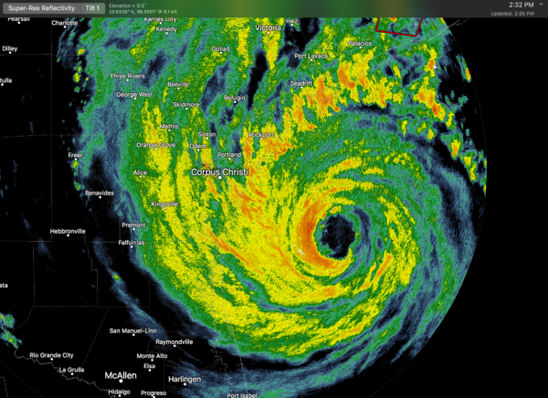
DANGEROUS HARVEY NEARING THE TEXAS COAST: Harvey is now a very dangerous category three hurricane with sustained winds of 120 mph and a central pressure of 943 mb. Landfall is expected early tomorrow morning just north of Corpus Christi.
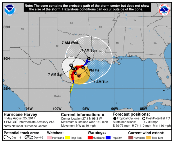
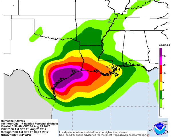
Steering currents will collapse, and Harvey is expected to hang around the Texas coastal plain for 4 to 5 days, creating potential for catastrophic flooding. Models suggest rain amounts averaging 15-30 inches, with isolated amounts of 3 to 4 feet (36 to 48 inches).
In addition, a few tornadoes are possible north of the circulation center over the upper Texas coast through Sunday. Harvey is an extremely dangerous, life threatening storm.
INVEST 92L: The disturbance over the Florida Peninsula will move northeast, and has some potential to become Tropical Storm Irma early next week. It should stay just off the East Coast of the U.S. and will have no impact on Alabama weather.
See the Weather Xtreme video for maps, graphics, and more details.
BEACH FORECAST: Click here to see the AlabamaWx Beach Forecast Center page. The Beach Forecast is partially underwritten by the support of Brett/Robinson Vacation Rentals in Gulf Shores and Orange Beach. Click here to see Brett/Robinson’s Hot Deals now!
WEATHER BRAINS: Don’t forget you can listen to our weekly 90 minute netcast anytime on the web, or on iTunes. This is the show all about weather featuring many familiar voices, including our meteorologists here at ABC 33/40.
CONNECT: You can find me on all of the major social networks…
Facebook
Twitter
Google Plus
Instagram
Pinterest
Snapchat: spannwx
I enjoyed seeing a big crowd today at Jasper’s First Baptist Church… look for my next Weather Xtreme video here Monday morning by 7:00 a.m… Brian Peters will have the video updates tomorrow and Sunday. Enjoy the weekend!
Category: Alabama's Weather, ALL POSTS, Weather Xtreme Videos
About the Author (Author Profile)
James Spann is one of the most recognized and trusted television meteorologists in the industry. He holds the AMS CCM designation and television seals from the AMS and NWA. He is a past winner of the Broadcast Meteorologist of the Year from both professional organizations.Subscribe
If you enjoyed this article, subscribe to receive more just like it.


