

Flash Flood Emergency For Houston
Another frightening situation is setting up for the Houston Metro overnight as a firehose of thunderstorms along the outer feeder band of Tropical Storm Harvey is lined up to pour buckets of rainfall on the city.
Flooding over the next five days could rival that of Tropical Storm Allison, which was devastating in the Houston area.
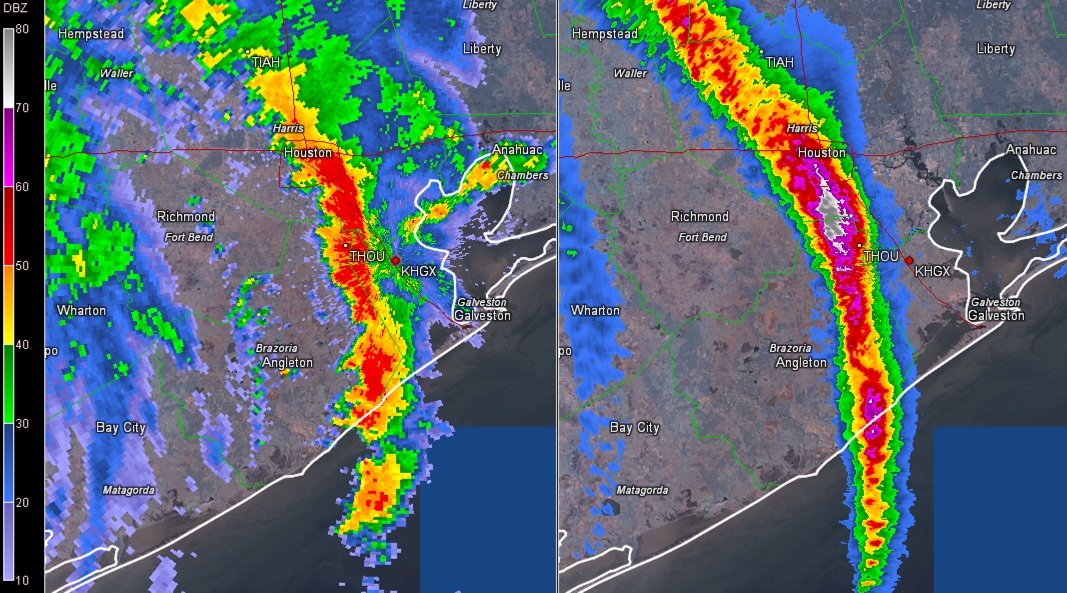
Here is the current radar on the left and one-hour rainfall estimates on the right. They are probably slightly underdone.
Here is the statement from the NWS Houston/Galveston:
Public Information Statement
National Weather Service Houston/Galveston TX
956 PM CDT Sat Aug 26 2017
…FLASH FLOOD EMERGENCY FOR West Central Harris, Eastern Fort Bend and
Northern Brazoria counties…
… Past 1 Hour Preliminary Rainfall Reports…
Location Amount Time/Date Lat/Lon
…Texas…
…Harris County…
Meyerland 3.97 in 0917 PM 08/26 29.66N/95.46W
Buffalo Bayou W Belt Drive 3.92 in 0922 PM 08/26 29.76N/95.56W
1 N West University Place 3.84 in 0939 PM 08/26 29.74N/95.43W
Brays Bayou At Rice Ave 3.76 in 0914 PM 08/26 29.68N/95.47W
Sims Bayou At Hiram Clarke S 3.52 in 0913 PM 08/26 29.62N/95.45W
2 SE Hunters Creek Village 3.48 in 0940 PM 08/26 29.75N/95.47W
Brays Bayou @ Beltway 8 3.44 in 0904 PM 08/26 29.69N/95.55W
Rummel Creek 3.44 in 0928 PM 08/26 29.78N/95.57W
6922 Old Katy Rd 3.24 in 0948 PM 08/26 29.78N/95.44W
Brays Bayou Gessner Dr 3.20 in 0917 PM 08/26 29.67N/95.53W
About the Author (Author Profile)
Bill Murray is the President of The Weather Factory. He is the site's official weather historian and a weekend forecaster. He also anchors the site's severe weather coverage. Bill Murray is the proud holder of National Weather Association Digital Seal #0001 @wxhistorianSubscribe
If you enjoyed this article, subscribe to receive more just like it.


