

A Quick Look At Saturday’s Weather For Central Alabama
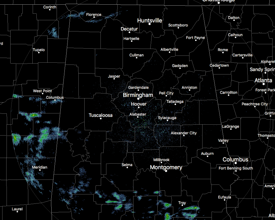
At the 1 o’clock hour in Central Alabama, we have clouds across much of the area at this point, with a few sprinkles falling over the southern parts. Most of the returns are not reaching the ground, but a few are. Temperatures are currently in the lower to mid-80s at this point, with the temps being held back some thanks to the cloud cover. Birmingham is currently at 82 degrees, while Eufaula is at 87 degrees, easily the warm spot.
For The Rest Of Today
It will be a partly to mostly cloudy day for the remainder of your Saturday. We could have a few sprinkles work into the southwestern parts of Central Alabama this afternoon, but most everyone stays dry. Afternoon highs will be in the mid-80s to 90 degrees. Those partly to mostly cloudy skies will carry over into the late evening and overnight hours, with lows in the upper 60s to the lower 70s throughout the area.
Sunday’s Weather
It will be close to what we’re having for today… partly to mostly cloudy skies with a very slight risk of isolated showers or storms mainly west of I-65. Afternoon highs will be in the mid-80s to 90 degrees. Skies will remain partly to mostly cloudy throughout the late evening and overnight hours, and lows will be in the upper 60s to the lower 70s.
Next Week
The forecast for much of the work week is still really up for grabs as we wait to see what will happen with Harvey. For now it looks like the rain chances will slowly increase throughout the week. Monday will have a small chance of isolated showers and storms for the western half of the area, while the east stays dry. Tuesday through Friday will feature a chance of scattered showers and storms each day, starting off at 1-in-4 odds of any one location getting rain on Tuesday and reaching 50/50 odds by Friday. Highs throughout the week will be in the mid to upper 80s. Of course, this may all change if Harvey gets picked up by a cold front that will be approaching the area late in the week.
Tropical Storm Harvey Continues To Dump Rain On Texas
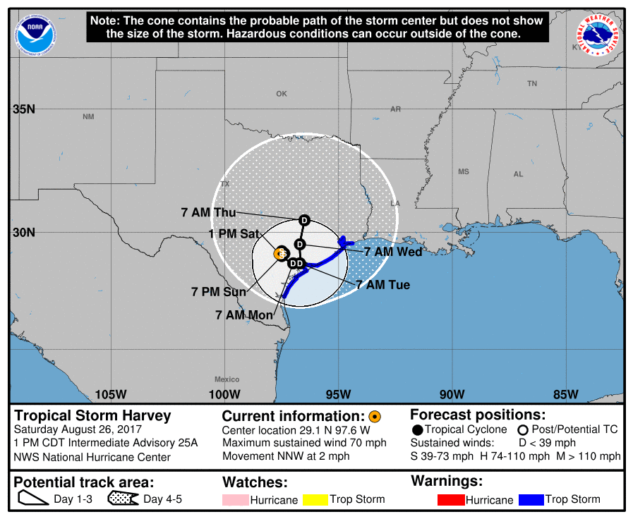
Harvey was just downgraded by the National Hurricane Center, as the maximum sustained winds have fallen to 70 MPH. Even though it is no longer a hurricane, the threat of life-threatening flooding, some spin-up tornadoes, and some wind damage continues for at least the next few days.
Heavy rain will continue to be the main story as Harvey is still able to pull moisture from the Gulf of Mexico, plus with it only moving to the north-northwest at 2 MPH, training will lead to even more flooding issues. The bad news is that very little movement is expected during the next several days. Rainfall amounts are expected to reach as high as 40 inches over parts of the middle and upper Texas coast, while most of the rest of the area from Corpus Christi to Victoria to receive anywhere from 15 to 30 inches.
There is a storm surge threat for parts of the coast, with highs of 2 to 7 feet expected as tropical storm force winds continue to force water into the bays and inlets. Also, tornadoes will be possible from the middle Texas coast all the way to far southwest Louisiana.
Latest forecast path has Harvey just meandering around the southeastern parts of Texas until Thursday when it finally moves northward a little into east-central Texas. Harvey is still forecast to be a depression on Thursday.

Invest 92L
This disturbance is currently located over north-central parts of the Florida Peninsula and is forecast to move slowly to the northeast and emerge out in the Atlantic. There is a medium chance that this could become Tropical Storm Irma within the next 5 days as it moves out to sea. There are no issues for Central Alabama from this one.
Got Beach Plans?
Be sure to keep up to date with the detailed forecasts from Fort Morgan over to Panama City Beach with the AlabamaWx Weather Blog. Click here to see the AlabamaWx Beach Forecast Center page.
The Beach Forecast is partially underwritten by the support of Brett/Robinson Vacation Rentals in Gulf Shores and Orange Beach. Click here to see Brett/Robinson’s Hot Deals now!
Advertise With Us!
Now is the time to set your marketing campaign on AlabamaWX. The site has enjoyed a 71% jump in page views this year! The website has already enjoyed 10,157,915 page views this year. We can customize a creative, flexible and affordable package that will suit your organization’s needs. Contact Bill Murray at (205) 687-0782.
E-Forecast
Get the AlabamaWx seven-day forecast delivered directly to your inbox by email twice daily. It is the most detailed weather forecast available in Central Alabama. Click here to subscribe. It’s free!
On This Day In Weather History
1883 – Krakatoa Volcano exploded in the East Indies. The explosion was heard more than 2500 miles away, and every barograph around the world recorded the passage of the air wave, up to seven times. Giant waves, 125 feet high and traveling 300 mph, devastated everything in their path, hurling ashore coral blocks weighing up to 900 tons, and killing more than 36,000 persons. Volcanic ash was carried around the globe in thirteen days producing blue and green suns in the tropics, and then vivid red sunsets in higher latitudes. The temperature of the earth was lowered one degree for the next two years, finally recovering to normal by 1888.
WeatherBrains
Check out the show at www.WeatherBrains.com. You can also subscribe on iTunes. You can watch the show live at live.bigbrainsmedia.com on Monday nights starting at 8:30 PM CDT. You will be able to see the show on the James Spann 24×7 weather channel on cable or directly over the air on the dot 2 feed.
Category: Alabama's Weather, ALL POSTS
About the Author (Author Profile)
Scott Martin is an operational meteorologist, professional graphic artist, musician, husband, and father. Not only is Scott a member of the National Weather Association, but he is also the Central Alabama Chapter of the NWA president. Scott is also the co-founder of Racecast Weather, which provides forecasts for many racing series across the USA. He also supplies forecasts for the BassMaster Elite Series events including the BassMaster Classic.Subscribe
If you enjoyed this article, subscribe to receive more just like it.


