Things Calming Down Across Alabama
Well, after a wild day with several scary moments, things are beginning to calm down as the atmosphere gives up its energy.
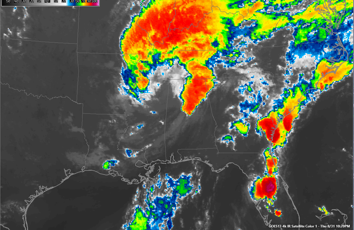
The tornado watch for parts of Central and North Alabama expired at 10 p.m. All warnings have expired.
The line of storms that flared starting about 6 p.m. has begun to weaken over the past 30 minutes. It extends from near Guntersville to the west of Gadsden to Pell City to Harpersville and Childersburg and to Jemison and Thorsby.
Lots of lightning and heavy rain, but no severe weather now.
The center of the remnants of Harvey is near Holly Springs in northern Mississippi. It is moving slowly northward now. A warm front lies across North Alabama in the US-278 Corridor. The warm front was key in the tornado formation process today.
A few showers will continue to form and rotate across the area through the overnight hours as the circulation spins over us. The rain will probably not end totally until tomorrow evening. Hopefully we will have better news for high school football games later on Friday.
Winds are currently averaging 15 mph across Central Alabama tonight, gusting to 20-25 at times. A wind advisory continues in effect for the northern half of the state. Lows will be in the upper 60s to lower 70s.
skies will remain cloudy over North Alabama on Friday with highs hanging in the lower 70s. Some sun should appear in the I-20 Corridor and points south, allowing the mercury to rise into the 80s.
Saturday, Sunday and Monday look dry with highs in the lower and middle 80s and lows in the middle 60s.
Hurricane Irma has leveled off tonight with top winds of 115 mph. Irma will continue to travel westward, and is forecast to turn west southwestward through the weekend, approaching the northern Leeward Islands by next Wednesday. From there it is anybody’s guess. The European is the lone global model bringing it to the Gulf of Mexico as a powerful hurricane by the 10th. The GFS Is slower and further north, exploiting a weakness in the ridge, potentially presenting a threat to the East Coast.
Category: Alabama's Weather, ALL POSTS
About the Author (Author Profile)
Bill Murray is the President of The Weather Factory. He is the site's official weather historian and a weekend forecaster. He also anchors the site's severe weather coverage. Bill Murray is the proud holder of National Weather Association Digital Seal #0001 @wxhistorianSubscribe
If you enjoyed this article, subscribe to receive more just like it.


