A Few Showers Today; Dry Labor Day Weekend
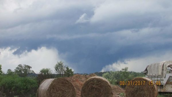
CALMER DAY: The remnant circulation of Harvey is near Nashville this morning; it brought severe storms to the western part of Alabama yesterday. A tornado touched down in Pickens and Fayette Counties producing extensive damage in places like Reform, Palmetto, and communities west of Fayette. NWS survey teams will be in there today to determine the EF rating. Four minor injuries were reported at Reform.
Drier air will work into Alabama today, but a few showers remain possible, especially over the northern third of the state closer to the surface low to the north.
LABOR DAY WEEKEND: We expect mostly sunny warm days and fair pleasant nights tomorrow through Monday with highs in the 80s and lows in the 60-65 degree range. Cooler pockets should see upper 50s.
FOOTBALL WEATHER: Mostly fair for the high school games tonight with temperatures falling through the 70s.
Alabama travels to Atlanta to take on Florida State tomorrow (7:00 p.m. CT kickoff on ABC 33/40); the game will be played in the new Mercedes-Benz stadium indoors. Outside, the waether will be dry tomorrow and tomorrow night.. temperatures will reach the low to mid 80s in Atlanta Saturday afternoon.
Auburn will host Georgia Southern tomorrow evening at Jordan-Hare Stadium (6:30p CT kickoff)… we project a mostly fair sky.. the kickoff temperature will be near 80 degrees, falling into the low 70s by the final whistle.
UAB will host Alabama A&M tomorrow afternoon at Legion Field (2:30p CT kickoff on WABM, MY68)… with a partly to mostly sunny sky temperatures will be around 85 degrees at kickoff, falling to near 80 by the end of the game.
LABOR DAY WEEKEND AT THE BEACH: Partly to mostly sunny weather tomorrow through Monday from Gulf Shores west to Panama City Beach; just a few widely scattered showers or storms each day. Highs in the 80s.
NEXT WEEK: A cold front will bring a chance of showers Tuesday into part of the day Wednesday, but no severe weather is expected. Rain amounts of around 1/2 inch are likely, and following that front we will enjoy some refreshing air Thursday and Friday with highs dropping into the 70s and lows in the 50s. Both of these days will be dry.
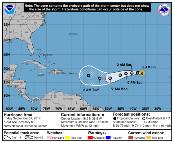
IRMA: Now a major hurricane with sustained winds estimated at 115 mph, Irma will move westward across the open Atlantic in coming days, and is expected to be somewhere east of the Leeward Islands by the middle part of next week.
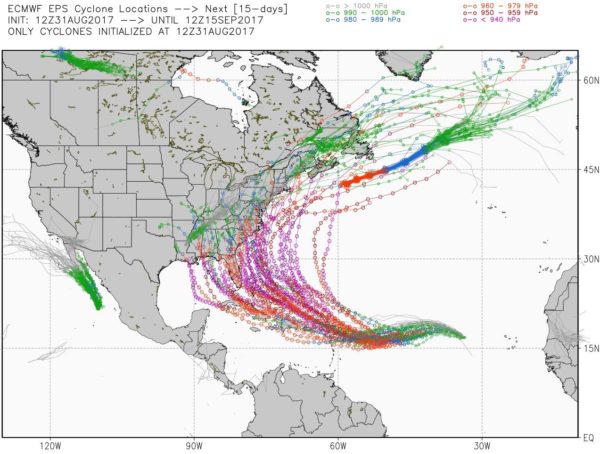
Beyond this, there is considerable spread in model output. Looking at the European model ensemble (ECMWF) with 51 members, you have a spread all the way from the Gulf of Mexico on the west wide, to a recurving scenario in the open Atlantic on the east side. You will see all kinds of crazy claims on social media, but NOBODY knows the ultimate destination of Irma, and we won’t have a good idea until 4-5 days from now.
Another wave has emerged off the coast of Africa, and has some chance of development in coming days over the open Atlantic on the journey westward. See the Weather Xtreme video for maps, graphics, and more details.
WEATHER BRAINS: Don’t forget you can listen to our weekly 90 minute netcast anytime on the web, or on iTunes. This is the show all about weather featuring many familiar voices, including our meteorologists here at ABC 33/40.
CONNECT: You can find me on all of the major social networks…
Facebook
Twitter
Google Plus
Instagram
Pinterest
Snapchat: spannwx
Look for the next Weather Extreme video here by 4:00 this afternoon… enjoy the day!
Category: Alabama's Weather, ALL POSTS, Weather Xtreme Videos
About the Author (Author Profile)
James Spann is one of the most recognized and trusted television meteorologists in the industry. He holds the AMS CCM designation and television seals from the AMS and NWA. He is a past winner of the Broadcast Meteorologist of the Year from both professional organizations.Subscribe
If you enjoyed this article, subscribe to receive more just like it.


