Delightful Labor Day Weekend Ahead
SO LONG HARVEY: We still have some “wrap around” clouds on the back side of former Tropical Storm Harvey over Northeast Alabama this afternoon, but most of Alabama is enjoying a good supply of sunshine with temperatures in the low 80s. Scattered showers over Northeast Alabama will end this evening, and the sky will be mostly fair late tonight, and we drop into the 60-65 degree range early tomorrow morning.
LABOR DAY WEEKEND: Dry air is the story; look for mostly sunny warm days, fair pleasant nights through Monday. Highs in the 80s, lows mostly in the 60s, but cooler pockets will have a good chance of seeing lows down in the upper 50s.
FOOTBALL WEATHER: Mostly fair for the high school games tonight with temperatures falling through the 70s.
Alabama travels to Atlanta to take on Florida State tomorrow (7:00 p.m. CT kickoff on ABC 33/40); the game will be played in the new Mercedes-Benz stadium indoors. Outside, the waether will be dry tomorrow and tomorrow night.. temperatures will reach the low to mid 80s in Atlanta Saturday afternoon.
Auburn will host Georgia Southern tomorrow evening at Jordan-Hare Stadium (6:30p CT kickoff)… we project a mostly fair sky.. the kickoff temperature will be near 80 degrees, falling into the low 70s by the final whistle.
UAB will host Alabama A&M tomorrow afternoon at Legion Field (2:30p CT kickoff on WABM, MY68)… with a partly to mostly sunny sky temperatures will be around 85 degrees at kickoff, falling to near 80 by the end of the game.
LABOR DAY WEEKEND AT THE BEACH: Partly to mostly sunny weather tomorrow through Monday from Gulf Shores west to Panama City Beach; just a few widely scattered showers or storms each day. Highs in the 80s.
NEXT WEEK: Showers are possible Tuesday and Wednesday as a cold front slices into the state, then cooler, drier air rolls in for Thursday and Friday with highs 77-80, and lows down in the cool 50s. It will really feel like fall.
IMRA: Now a category two hurricane in the Atlantic, it will move west/northwest in coming days, and should be a major hurricane just east of the Leeward Islands by the middle of next week.
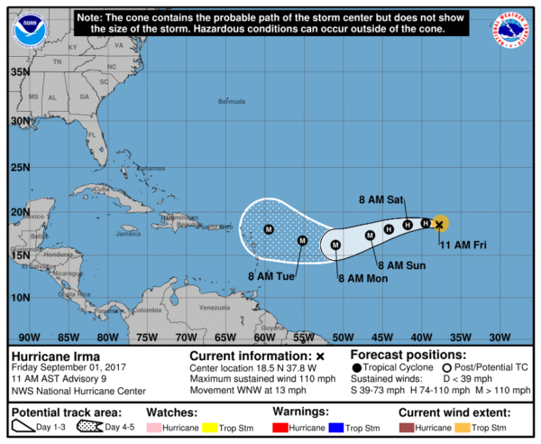
From there, NOBODY knows the ultimate destination, despite what you might see on social media. All solutions remain on the table; we will have better clarity next week.
Another tropical wave has come off the coast of Africa; it could become Tropical Storm Jose in coming days as it moves to the west.
WEATHER BRAINS: Don’t forget you can listen to our weekly 90 minute netcast anytime on the web, or on iTunes. This is the show all about weather featuring many familiar voices, including our meteorologists here at ABC 33/40.
CONNECT: You can find me on all of the major social networks…
Facebook
Twitter
Google Plus
Instagram
Pinterest
Snapchat: spannwx
Look for my next Weather Xtreme video here Monday morning by 7:00 a.m…. Brian Peters will have the video updates here tomorrow and Sunday. Enjoy the weekend!
Category: Alabama's Weather, ALL POSTS, Weather Xtreme Videos
About the Author (Author Profile)
James Spann is one of the most recognized and trusted television meteorologists in the industry. He holds the AMS CCM designation and television seals from the AMS and NWA. He is a past winner of the Broadcast Meteorologist of the Year from both professional organizations.Subscribe
If you enjoyed this article, subscribe to receive more just like it.


