Lovely Labor Day Weekend Weather
It has been a pleasure having the opportunity to work with Dave Baird at ABC 3340 over the last 13 plus years. Dave edged off into retirement last night with his final newscast. I sure wish him the best in whatever he chooses to do next.
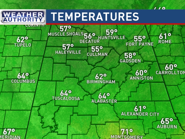
Our SkyWatcher at Black Creek reported a low of 54 degrees this morning with widespread readings in the 50s across the Tennessee Valley. The surface circulation around the departing Harvey currently over northern Kentucky has brought some cooler, drier air into the Southeast US setting us up for a very nice Labor Day Weekend. Highs later today should reach the middle 80s. Another great day in store for us on Sunday and Monday, too, as the weather remains very nice. Temperatures will warm up some by Monday, though, as we see our highs nudge very close to 90.
The football weather looks great, too. Alabama travels to Atlanta to take on Florida State tomorrow with a 7:00 pm CDT kickoff on ABC 33/40; the game will be played in the new Mercedes-Benz stadium indoors, but outside, the weather will be dry today and tonight with high temperatures reaching the lower 80s in Atlanta this afternoon. Evening temperatures will be falling through the 70s. Auburn will host Georgia Southern tonight at Jordan-Hare Stadium with a 6:30 pm CDT kickoff. Forecast looks good with a fair sky and the kickoff temperature near 80 degrees falling into the low 70s by the final whistle. UAB hosts Alabama A&M this afternoon at Legion Field with a 2:30 pm CDT kickoff on WABM, MY68, with a mostly sunny sky with temperatures around 84 degrees at kickoff falling to near 80 by the end of the game.
LABOR DAY WEEKEND AT THE BEACH: Partly to mostly sunny weather today through Monday from Gulf Shores to Panama City Beach; just a few widely scattered showers or storms each day. Highs in the 80s. Be sure to keep up to date with the detailed forecasts from Fort Morgan to Panama City Beach with the AlabamaWx Weather Blog. Click here to see the AlabamaWx Beach Forecast Center page. The Beach Forecast is partially underwritten by the support of Brett/Robinson Vacation Rentals in Gulf Shores and Orange Beach. Click here to see Brett/Robinson’s Hot Deals now!
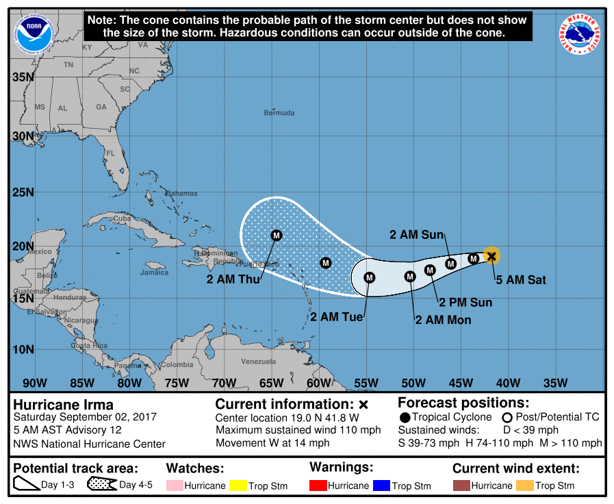
In the tropical Atlantic, most eyes are on Irma as she is forecast to achieve major hurricane status later today despite fluctuations in intensity. The latest forecast projects Irma riding very close to the northern Leeward Islands of Wednesday and north of Puerto Rico on Thursday. There is still a good deal of variation in the forecasts after that. Be sure to watch the video for the graphics showing an amazing difference between the ECMWF and the GFS at 204 hours (Sunday a week from tomorrow). Behind Irma was an area of disturbed weather that should encounter environmental conditions that are expected to become more conducive for development in a couple of days. So this system could become a tropical depression early next week as it moves westward at 15 mph over the tropical Atlantic. This storm is further south than Irma, so there appears to be a good chance it will enter the eastern Caribbean next week.
A very strong trough moves into the western Great Lakes area on Tuesday and pushes southward on Wednesday. A surface front is forecast to reach the Ohio River Valley on Tuesday and move into Alabama early Wednesday. Much of the day Tuesday should be dry but rain chances are expected to ramp up quickly as the front moves into the Southeast US. Looks like Wednesday could be one of those days with lots of clouds and numerous showers and thunderstorms and highs only in the 70s. The risk for severe weather appears to be fairly low at this point in time, but with some instability present we’ll need to watch for the possibility of isolated severe thunderstorms. Overall structure does not appear sufficient to support any significant severe weather threat.
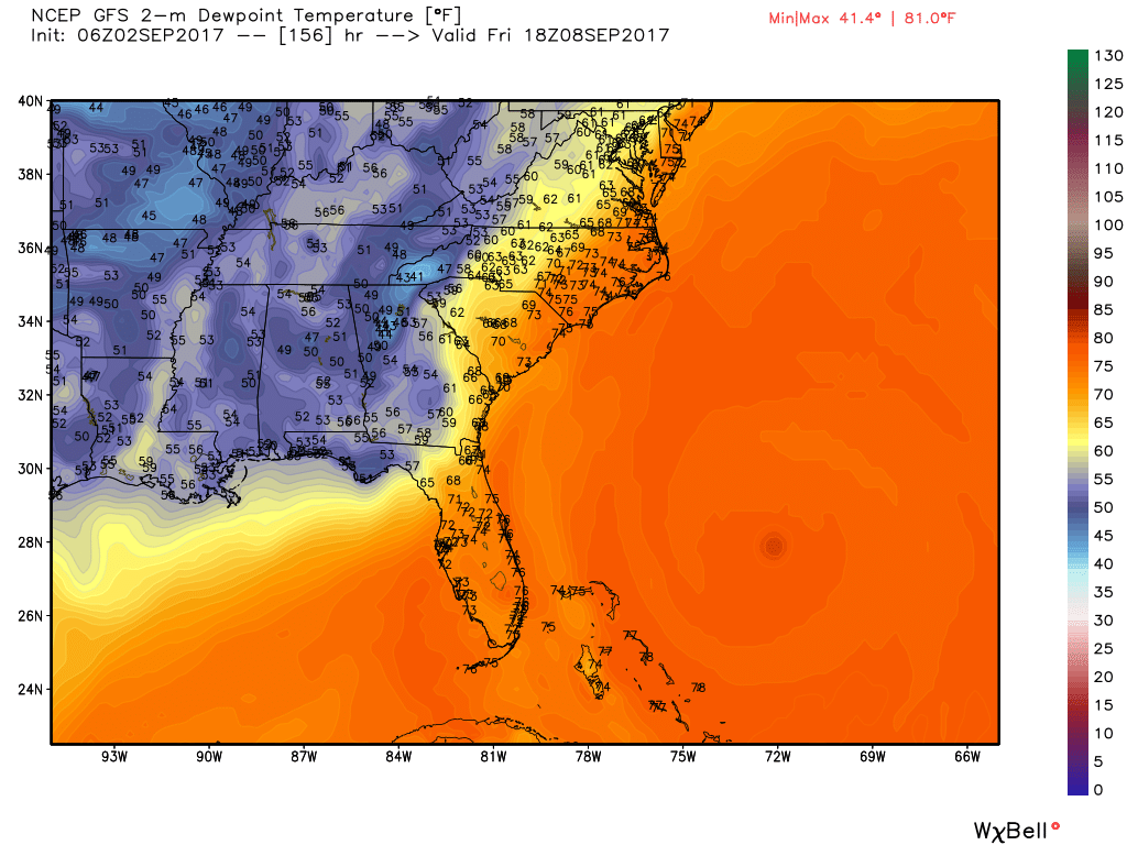
The upper trough digs in a little further on Thursday quickly putting an end to the precipitation, but keeping us in a rather cool patter. I suspect it will be another cool day Thursday with highs in the 70s once again as we clear out and see the advection of much lower dew points into the area. Friday looks like a cool, dry day with highs in the upper 70s, but the lower humidity with dew points in the 50s should give as a great taste of Fall.
The upper trough weakens into the start of next weekend, so we should see highs climb a bit with highs getting into the lower 80s. Very late in this forecast cycle and verging into voodoo country we’ll have to deal with Irma and where she might go. As I mentioned earlier, the GFS and the ECMWF are quite different with the projected position of Irma over 1200 miles different. The ECMWF has a position treating South Florida while the GFS has Irma in Central New York state.
Looking further into voodoo country, the GFS maintains ridging in the West and weak troughing in the East. The GFS also brings a tropical system into the southern Bahamas around the 13th of September but keeps that system in the Atlantic with a potential threat to Bermuda around the 17th. This pattern would pump up the ridge over the Tennessee and Ohio river valleys at mid September and produce a short warm period.
I will plan to post the next Weather Xtreme Video here around 7 am on Sunday. Enjoy the wonderful early September days. Godspeed.
-Brian-
Category: Alabama's Weather, ALL POSTS
About the Author (Author Profile)
Brian Peters is one of the television meteorologists at ABC3340 in Birmingham and a retired NWS Warning Coordination Meteorologist. He handles the weekend Weather Xtreme Videos and forecast discussion and is the Webmaster for the popular WeatherBrains podcast.Subscribe
If you enjoyed this article, subscribe to receive more just like it.


