Irma Now A Category Five Hurricane
Needless to say, much of what I write here today will be focused on Hurricane Irma, but let’s get the Alabama weather situation out of the way…
COLD FRONT ARRIVES LATE TONIGHT: We will bring in a chance of showers, and possibly a few thunderstorms for Alabama this afternoon and tonight ahead of a cold front. No severe weather is expected, and rain amounts should be generally around 1/2 inch. The high today will be in the mid 80s for most communities.
TOMORROW THROUGH FRIDAY: A cool, refreshing airmass drops into Alabama overnight; any showers tomorrow should be confined to the far southern counties of the state. The high will drop into the mid to upper 70s with a fresh north breeze and low humidity. By Thursday morning, cooler pockets across North/Central Alabama could reach the upper 40s, with 50s elsewhere. The weather stays dry and very pleasant Thursday and Friday with a good supply of sunshine both days.
THE ALABAMA WEEKEND: Dry air stays in place; we will continue to forecast sunny pleasant days and fair cool nights; highs in the low 80s… lows between 58 and 62. The weather looks fantastic for high school and college football games this weekend.
NEXT WEEK: Our weather Monday and Tuesday will be determined by the track of Hurricane Irma; there is some chance rain could creep into East Alabama, but most of the state will be dry and pleasant through the week.
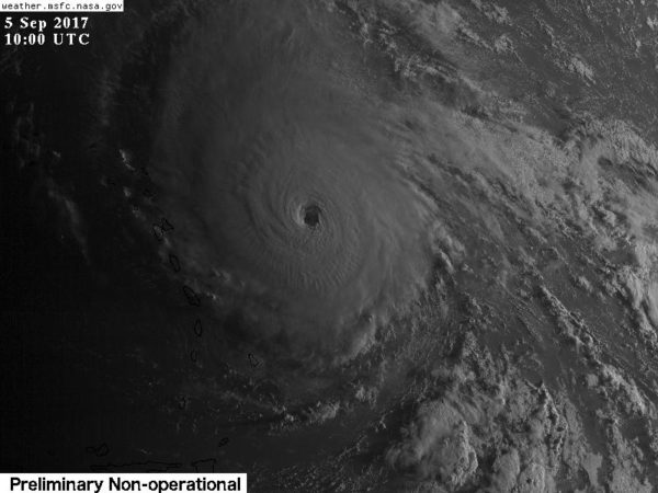
IRMA NOW A CATEGORY FIVE: Irma is headed for the northern Leeward Islands with sustained winds of 175 mph; a rare category five hurricane. The central pressure is down to 929 mb.
A Hurricane Warning is in effect for…
* Antigua, Barbuda, Anguilla, Montserrat, St. Kitts, and Nevis
* Saba, St. Eustatius, and Sint Maarten
* Saint Martin and Saint Barthelemy
* British Virgin Islands
* U.S. Virgin Islands
* Puerto Rico, Vieques, and Culebra
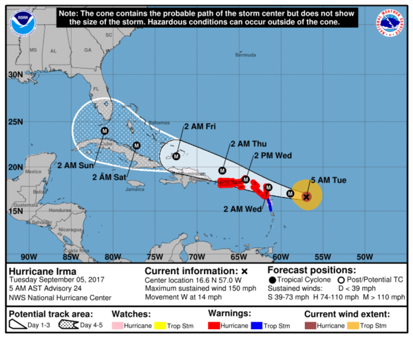
Irma most likely will directly affect Hispaniola, the Turks and Caicos, the Bahamas, and Cuba as a dangerous major hurricane later this week. Residents in these areas should monitor the progress of Irma and listen to advice given by officials.
Irma is forecast to be just southeast of Key West Saturday night…
Here are the important points…
*Do not focus on the exact forecast forecast track, especially at the longer ranges, since the average NHC track errors are about 175 and 225 statute miles at days 4 and 5, respectively.
*Irma is expected to make a hard right turn over the weekend in response to a deep upper trough over the eastern half of the U.S. Exactly when that turn happens will determine the ultimate impact on the Florida Peninsula.
*Unfortunately, both primary global models (the American GFS and the European ECMWF) show the core of Irma moving northward, through the spine of the Florida Peninsula, in the Sunday/Monday time frame. This, of course, could change, but there is excellent model agreement in this idea.
*People in the Florida Peninsula need to continue preparations for a major hurricane, and listen carefully to statements from local governments later this week as some evacuation orders will most likely be needed. Tropical storm force winds could reach South Florida as early as Friday night.
*It is unlikely that Irma enters the Gulf of Mexico, based on current model output. For now, we expect little, if any impact on places like Gulf Shores, Pensacola, Navarre Beach, and Destin. Panama City Beach could see some wind and rain Sunday or Monday, but they will be on the “good”, drier side of the hurricane most likely. Of course, this could change, so pay close attention to updates in coming days.
*For most of Alabama, we expect little or no impact, although some rain could creep into East Alabama Monday or Tuesday. Again, we should be on the “good” side of the hurricane.
*Always use fresh, updated weather information. With any tropical system forecast changes are very possible, if not likely, as it goes closer to land and the prime U.S. upper air network. Thankfully both USAF and NOAA aircraft are collecting data this morning; this goes into the computer models we use to make them more reliable. Sometimes large category 4/5 hurricanes can literally create their own steering currents.
REST OF THE TROPICS: A wave trailing Irma could become Tropical Storm Jose in coming days; no threat to land in the short term as it expected to gain latitude. And, a disturbance in the Bay of Campeche could show development in coming days; most likely it drifts into Mexico.
BEACH FORECAST: Click here to see the AlabamaWx Beach Forecast Center page. The Beach Forecast is partially underwritten by the support of Brett/Robinson Vacation Rentals in Gulf Shores and Orange Beach. Click here to see Brett/Robinson’s Hot Deals now!
WEATHER BRAINS: Don’t forget you can listen to our weekly 90 minute netcast anytime on the web, or on iTunes. This is the show all about weather featuring many familiar voices, including our meteorologists here at ABC 33/40. We will produce this week’s show tonight at 8:30p CT… you can watch it live here.
CONNECT: You can find me on all of the major social networks…
Facebook
Twitter
Google Plus
Instagram
Pinterest
Snapchat: spannwx
I am speaking this morning to a group of senior adults in Talladega… look for the next Weather Xtreme video see by 4:00 this afternoon… enjoy the day!
Category: Alabama's Weather, ALL POSTS, Weather Xtreme Videos
About the Author (Author Profile)
James Spann is one of the most recognized and trusted television meteorologists in the industry. He holds the AMS CCM designation and television seals from the AMS and NWA. He is a past winner of the Broadcast Meteorologist of the Year from both professional organizations.Subscribe
If you enjoyed this article, subscribe to receive more just like it.


