Severe Thunderstorm Warning Expired For Parts Of Dekalb And Jackson Counties
…THE SEVERE THUNDERSTORM WARNING FOR SOUTH CENTRAL JACKSON AND
CENTRAL DEKALB COUNTIES WILL EXPIRE AT 430 PM CDT…
The storms which prompted the warning have weakened below severe
limits, and no longer pose an immediate threat to life or property.
Therefore the warning will be allowed to expire. However small
hail, gusty winds, heavy rain, and frequent lightning are still
possible with these thunderstorms.
Severe Thunderstorm Warning Continues For Parts Of Dekalb And Jackson Counties Until 4:30PM
Sep 5th @ 4:05 pm

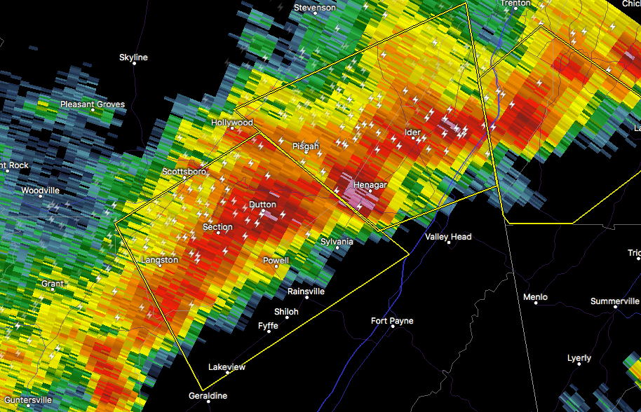
…A SEVERE THUNDERSTORM WARNING REMAINS IN EFFECT UNTIL 430 PM CDT FOR SOUTH CENTRAL JACKSON AND CENTRAL DEKALB COUNTIES… At 419 PM CDT, a severe thunderstorm was located near Sylvania, or near Rainsville, moving southeast at 25 mph.
HAZARD…60 mph wind gusts and half dollar size hail.
SOURCE…Radar indicated.
IMPACT…Hail damage to vehicles is expected. Expect wind damage to roofs, siding, and trees. Locations impacted include… Scottsboro, Rainsville, Henagar, Sylvania, Fyffe, Powell, Section, Dutton and Shiloh.
Severe Thunderstorm Warning Issued For Parts Of Dekalb And Jackson Counties Until 4:30PM
Sep 5th @ 4:05 pm

The National Weather Service in Huntsville Alabama has issued a
* Severe Thunderstorm Warning for…
South central Jackson County in northeastern Alabama…
Central DeKalb County in northeastern Alabama…
* Until 430 PM CDT
* At 404 PM CDT, a severe thunderstorm was located over Section, or near Scottsboro, moving southeast at 15 mph.
HAZARD…60 mph wind gusts and half dollar size hail.
SOURCE…Radar indicated.
IMPACT…Hail damage to vehicles is expected. Expect wind damage to roofs, siding, and trees.
* Locations impacted include…
Scottsboro, Rainsville, Henagar, Sylvania, Fyffe, Powell, Geraldine, Section, Dutton and Shiloh.
Category: Archived Warnings
About the Author (Author Profile)
Subscribe
If you enjoyed this article, subscribe to receive more just like it.


